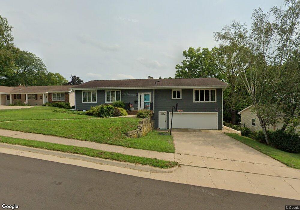
1311 Tomahawk Dr Dubuque, IA 52003
Estimated Value: $324,000 - $359,000
4
Beds
3
Baths
3,068
Sq Ft
$111/Sq Ft
Est. Value
About This Home
This home is located at 1311 Tomahawk Dr, Dubuque, IA 52003 and is currently estimated at $339,880, approximately $110 per square foot. 1311 Tomahawk Dr is a home located in Dubuque County with nearby schools including Bryant Elementary School, George Washington Middle School, and Dubuque Senior High School.
Ownership History
Date
Name
Owned For
Owner Type
Purchase Details
Closed on
Oct 24, 2011
Sold by
Renier Norma J and Renier Norma J
Bought by
Hoyer William C and Cooper Kate M
Current Estimated Value
Home Financials for this Owner
Home Financials are based on the most recent Mortgage that was taken out on this home.
Original Mortgage
$149,600
Outstanding Balance
$102,131
Interest Rate
4.12%
Mortgage Type
New Conventional
Estimated Equity
$237,749
Create a Home Valuation Report for This Property
The Home Valuation Report is an in-depth analysis detailing your home's value as well as a comparison with similar homes in the area
Purchase History
| Date | Buyer | Sale Price | Title Company |
|---|---|---|---|
| Hoyer William C | $187,000 | None Available |
Source: Public Records
Mortgage History
| Date | Status | Borrower | Loan Amount |
|---|---|---|---|
| Open | Hoyer William C | $149,600 |
Source: Public Records
Tax History
| Year | Tax Paid | Tax Assessment Tax Assessment Total Assessment is a certain percentage of the fair market value that is determined by local assessors to be the total taxable value of land and additions on the property. | Land | Improvement |
|---|---|---|---|---|
| 2025 | $4,200 | $330,200 | $57,600 | $272,600 |
| 2024 | $4,200 | $302,300 | $53,000 | $249,300 |
| 2023 | $4,074 | $302,300 | $53,000 | $249,300 |
| 2022 | $3,986 | $249,930 | $50,690 | $199,240 |
| 2021 | $3,986 | $249,930 | $50,690 | $199,240 |
| 2020 | $3,724 | $224,760 | $50,690 | $174,070 |
| 2019 | $3,676 | $218,240 | $50,690 | $167,550 |
| 2018 | $3,616 | $206,280 | $50,690 | $155,590 |
| 2017 | $3,556 | $206,280 | $50,690 | $155,590 |
| 2016 | $3,556 | $192,630 | $50,690 | $141,940 |
| 2015 | $3,480 | $192,630 | $50,690 | $141,940 |
| 2014 | $3,494 | $189,850 | $50,690 | $139,160 |
Source: Public Records
Map
Nearby Homes
- 935 Indian Ridge
- 1280 S Grandview Ave
- 966 Victoria St
- 1047 Shady Oaks Dr
- 1725 Plymouth Ct
- 626 Bradley St
- LOT 2-2 Kelly Ln
- 1025 Carmel Dr
- 1735 Creek Wood Dr
- Lot 128 Edenbrook Ln
- Lot 126 Edenbrook Ln
- Lot 125 Edenbrook Ln
- Lot 130 Edenbrook Ln
- Lot 127 Edenbrook Ln
- 2438 Rolling Creek Ln
- 823 Kelly Ln
- Lot 35 Fieldstone Ct
- Lot 129 Rolling Creek Ln
- Lot 24 Rolling Creek Ln
- Lot 25 Rolling Creek Ln
- 1307 Tomahawk Dr
- 1315 Tomahawk Dr
- 1319 Tomahawk Dr
- 1303 Tomahawk Dr
- 1312 Tomahawk Dr
- 1306 Tomahawk Dr
- 1316 Tomahawk Dr
- 1320 Tomahawk Dr
- 1321 Tomahawk Dr
- 1301 Tomahawk Dr
- 1324 Tomahawk Dr
- 1300 Tomahawk Dr
- 1190 Southern Ave
- 1325 Tomahawk Dr
- 1170 Southern Ave
- 1326 Tomahawk Dr
- 1329 Tomahawk Dr
- 1150 Southern Ave
- 1353 Tomahawk Dr
- 1098 Southern Ave
Your Personal Tour Guide
Ask me questions while you tour the home.