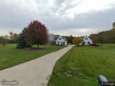
13115 E Heather Ln Columbia Station, OH 44028
Estimated Value: $476,000 - $622,000
3
Beds
3
Baths
2,485
Sq Ft
$223/Sq Ft
Est. Value
About This Home
This home is located at 13115 E Heather Ln, Columbia Station, OH 44028 and is currently estimated at $553,368, approximately $222 per square foot. 13115 E Heather Ln is a home located in Lorain County with nearby schools including Copopa Elementary School, Columbia Middle School, and Columbia High School.
Ownership History
Date
Name
Owned For
Owner Type
Purchase Details
Closed on
Jul 23, 2002
Sold by
Schroder Robert C and Schroder Susan L
Bought by
Lewicki Norman F and Buchholz Lynne D
Current Estimated Value
Home Financials for this Owner
Home Financials are based on the most recent Mortgage that was taken out on this home.
Original Mortgage
$316,800
Interest Rate
6.8%
Mortgage Type
Purchase Money Mortgage
Purchase Details
Closed on
Nov 18, 1996
Sold by
Shore West Const Co
Bought by
Schroder Robert C and Schroder Susan
Home Financials for this Owner
Home Financials are based on the most recent Mortgage that was taken out on this home.
Original Mortgage
$160,000
Interest Rate
8.18%
Mortgage Type
New Conventional
Create a Home Valuation Report for This Property
The Home Valuation Report is an in-depth analysis detailing your home's value as well as a comparison with similar homes in the area
Home Values in the Area
Average Home Value in this Area
Purchase History
| Date | Buyer | Sale Price | Title Company |
|---|---|---|---|
| Lewicki Norman F | $396,000 | Chicago Title Insurance Comp | |
| Schroder Robert C | $320,000 | -- |
Source: Public Records
Mortgage History
| Date | Status | Borrower | Loan Amount |
|---|---|---|---|
| Open | Lewicki Norman F | $274,300 | |
| Closed | Lewicki Norman F | $313,574 | |
| Closed | Buchholz Lynne D | $314,550 | |
| Closed | Lewicki Norman F | $316,800 | |
| Closed | Schroder Robert C | $40,000 | |
| Closed | Schroder Robert C | $160,000 |
Source: Public Records
Tax History Compared to Growth
Tax History
| Year | Tax Paid | Tax Assessment Tax Assessment Total Assessment is a certain percentage of the fair market value that is determined by local assessors to be the total taxable value of land and additions on the property. | Land | Improvement |
|---|---|---|---|---|
| 2024 | $6,241 | $151,004 | $36,894 | $114,111 |
| 2023 | $7,536 | $159,009 | $31,871 | $127,138 |
| 2022 | $7,304 | $159,009 | $31,871 | $127,138 |
| 2021 | $7,377 | $159,009 | $31,871 | $127,138 |
| 2020 | $7,478 | $145,480 | $29,160 | $116,320 |
| 2019 | $7,433 | $145,480 | $29,160 | $116,320 |
| 2018 | $7,504 | $145,480 | $29,160 | $116,320 |
| 2017 | $8,410 | $150,940 | $35,860 | $115,080 |
| 2016 | $8,472 | $150,940 | $35,860 | $115,080 |
| 2015 | $8,513 | $150,940 | $35,860 | $115,080 |
| 2014 | $6,148 | $131,260 | $31,190 | $100,070 |
| 2013 | $6,148 | $131,260 | $31,190 | $100,070 |
Source: Public Records
Map
Nearby Homes
- 11692 White Tail Run
- 23367 St Andrews Dr
- 24928 Copopa Trail
- 24851 Eagle Pointe
- 11358 White Tail Run
- 23789 Snell Rd
- 23213 Snell Rd
- 25077 Saddlehorn Cir
- 23580 Victory Ln
- 0 E River Rd Unit 5120285
- 10261 Baker Creek Ln
- 23730 Wally's Way
- 23459 St Andrews Dr
- 23378 St Andrews Dr
- 1046 Ashford Ct
- 1030 Ashford Ct
- 23669 Wally's Way
- 10444 E River Rd
- S/L 77 Marshcreek Way
- 23570 Eastbrook Dr
- 13115 E Heather Ln
- 13087 E Heather Ln
- 13163 E Heather Ln
- 13066 E Heather Ln
- 13049 E Heather Ln
- 14067 W Heather Ln
- 14150 W Heather Ln
- 14126 W Heather Ln
- 13001 E Heather Ln
- 14088 W Heather Ln
- 13020 E Heather Ln
- 14011 W Heather Ln
- 14052 W Heather Ln
- 14004 W Heather Ln
- 24481 Snell Rd
- 24455 Snell Rd
- 24507 Snell Rd
- 24433 Snell Rd
- 24529 Snell Rd
- 24409 Snell Rd