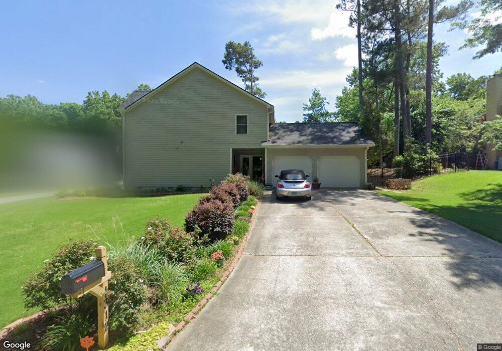
1312 Milstead Trace NE Unit 1 Marietta, GA 30066
Sandy Plains NeighborhoodEstimated Value: $455,281 - $561,000
4
Beds
3
Baths
2,196
Sq Ft
$230/Sq Ft
Est. Value
About This Home
This home is located at 1312 Milstead Trace NE Unit 1, Marietta, GA 30066 and is currently estimated at $504,820, approximately $229 per square foot. 1312 Milstead Trace NE Unit 1 is a home located in Cobb County with nearby schools including Kincaid Elementary School, Daniell Middle School, and Sprayberry High School.
Ownership History
Date
Name
Owned For
Owner Type
Purchase Details
Closed on
Sep 1, 2009
Sold by
Laird Cory M
Bought by
Laird Heather H
Current Estimated Value
Home Financials for this Owner
Home Financials are based on the most recent Mortgage that was taken out on this home.
Original Mortgage
$184,450
Outstanding Balance
$119,647
Interest Rate
5.11%
Mortgage Type
New Conventional
Estimated Equity
$385,173
Purchase Details
Closed on
Apr 19, 2002
Sold by
Kennedy Kennedy H and Kennedy Rebecca H
Bought by
Laird Corey M and Laird Heather H
Home Financials for this Owner
Home Financials are based on the most recent Mortgage that was taken out on this home.
Original Mortgage
$185,725
Interest Rate
7.07%
Mortgage Type
New Conventional
Create a Home Valuation Report for This Property
The Home Valuation Report is an in-depth analysis detailing your home's value as well as a comparison with similar homes in the area
Home Values in the Area
Average Home Value in this Area
Purchase History
| Date | Buyer | Sale Price | Title Company |
|---|---|---|---|
| Laird Heather H | -- | -- | |
| Laird Corey M | $195,500 | -- |
Source: Public Records
Mortgage History
| Date | Status | Borrower | Loan Amount |
|---|---|---|---|
| Open | Laird Heather H | $184,450 | |
| Previous Owner | Laird Corey M | $185,725 |
Source: Public Records
Tax History Compared to Growth
Tax History
| Year | Tax Paid | Tax Assessment Tax Assessment Total Assessment is a certain percentage of the fair market value that is determined by local assessors to be the total taxable value of land and additions on the property. | Land | Improvement |
|---|---|---|---|---|
| 2025 | $4,268 | $180,928 | $40,000 | $140,928 |
| 2024 | $4,226 | $178,848 | $27,200 | $151,648 |
| 2023 | $3,406 | $166,036 | $38,000 | $128,036 |
| 2022 | $3,585 | $147,992 | $27,200 | $120,792 |
| 2021 | $2,823 | $113,200 | $27,200 | $86,000 |
| 2020 | $2,823 | $113,200 | $27,200 | $86,000 |
| 2019 | $2,597 | $102,876 | $27,200 | $75,676 |
| 2018 | $2,597 | $102,876 | $27,200 | $75,676 |
| 2017 | $2,277 | $92,716 | $24,000 | $68,716 |
| 2016 | $2,040 | $81,860 | $24,000 | $57,860 |
| 2015 | $2,089 | $81,860 | $24,000 | $57,860 |
| 2014 | $1,967 | $75,648 | $0 | $0 |
Source: Public Records
Map
Nearby Homes
- 2839 Pine Meadow Dr
- 2116 Morgan Rd NE
- 2314 Sandy Oaks Dr
- 2642 Morgan Rd NE
- 1748 Brown Cir
- 1597 Sprayberry Dr
- 2742 Bob Bettis Rd
- 1386 Valmont Trace NE
- 1756 Brown Cir
- 1924 Wilkenson Crossing
- 2725 Stillwater Lake Ln Unit 2
- 2729 Stillwater Lake Ln Unit 1
- Robie Plan at The Village at Sandy Plains
- Harbor Plan at The Village at Sandy Plains
- Hanover Plan at The Village at Sandy Plains
- Bowen Plan at The Village at Sandy Plains
- Elston Plan at The Village at Sandy Plains
- BALDWIN Plan at The Village at Sandy Plains
- 1850 Butterfly Way NE
- 1780 Kinridge Rd
- 2321 Milstead Cir NE
- 1310 Milstead Trace NE
- 1311 Milstead Trace NE
- 2326 Milstead Cir NE
- 2326 Milstead Cir NE Unit 33
- 2324 Milstead Cir NE
- 2319 Milstead Cir NE
- 2328 Milstead Cir NE
- 1308 Milstead Trace NE Unit 2
- 1309 Milstead Trace NE
- 2317 Milstead Cir NE
- 2322 Milstead Cir NE
- 2315 Milstead Cir NE
- 2325 Milstead Cir NE
- 2320 Milstead Cir NE
- 2313 Milstead Cir NE
- 1306 Milstead Trace NE
- 1307 Milstead Trace NE
- 2332 Milstead Cir NE
- 2311 Milstead Cir NE