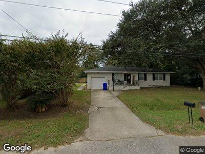
1313 Hermitage Ave Charleston, SC 29412
James Island NeighborhoodEstimated Value: $454,000 - $494,000
3
Beds
2
Baths
1,133
Sq Ft
$417/Sq Ft
Est. Value
About This Home
This home is located at 1313 Hermitage Ave, Charleston, SC 29412 and is currently estimated at $472,360, approximately $416 per square foot. 1313 Hermitage Ave is a home located in Charleston County with nearby schools including Harbor View Elementary School, Camp Road Middle, and James Island Charter High School.
Ownership History
Date
Name
Owned For
Owner Type
Purchase Details
Closed on
Aug 30, 2022
Sold by
Borden Trae W
Bought by
Borden Anna E and Borden Trae W
Current Estimated Value
Purchase Details
Closed on
May 7, 2010
Sold by
Corbett Diane Downey
Bought by
Borden Trae W
Home Financials for this Owner
Home Financials are based on the most recent Mortgage that was taken out on this home.
Original Mortgage
$168,727
Interest Rate
5.5%
Mortgage Type
FHA
Create a Home Valuation Report for This Property
The Home Valuation Report is an in-depth analysis detailing your home's value as well as a comparison with similar homes in the area
Home Values in the Area
Average Home Value in this Area
Purchase History
| Date | Buyer | Sale Price | Title Company |
|---|---|---|---|
| Borden Anna E | -- | -- | |
| Borden Trae W | $171,000 | -- |
Source: Public Records
Mortgage History
| Date | Status | Borrower | Loan Amount |
|---|---|---|---|
| Previous Owner | Borden Anna Elise | $404,000 | |
| Previous Owner | Borden Trae W | $155,562 | |
| Previous Owner | Borden Trae W | $168,727 |
Source: Public Records
Tax History Compared to Growth
Tax History
| Year | Tax Paid | Tax Assessment Tax Assessment Total Assessment is a certain percentage of the fair market value that is determined by local assessors to be the total taxable value of land and additions on the property. | Land | Improvement |
|---|---|---|---|---|
| 2023 | $3,483 | $12,420 | $0 | $0 |
| 2022 | $3,175 | $12,420 | $0 | $0 |
| 2021 | $3,161 | $12,420 | $0 | $0 |
| 2020 | $3,095 | $12,420 | $0 | $0 |
| 2019 | $2,871 | $10,800 | $0 | $0 |
| 2017 | $1,011 | $7,200 | $0 | $0 |
| 2016 | $971 | $7,200 | $0 | $0 |
| 2015 | $1,002 | $7,200 | $0 | $0 |
| 2014 | $886 | $0 | $0 | $0 |
| 2011 | -- | $0 | $0 | $0 |
Source: Public Records
Map
Nearby Homes
- 1402 Camp Rd Unit 8B
- 1402 Camp Rd Unit 10C
- 27 Brockman Dr Unit 27C
- 1224 Midvale Ave
- 1236 Midvale Ave
- 1418 Kentwood Cir
- 1114 Jeffery Dr
- 20 Anderson Ave
- 1174 Fort Johnson Rd
- 927 Dills Bluff Rd Unit G33
- 925 Dills Bluff Rd Unit G34
- 880 Simpkins St Unit 2
- 1172 Dawn Dr
- 1534 Kentwood Cir
- 1216 Taliaferro Ave
- 1404 Ivy Isle Dr
- 1198 Oakcrest Dr
- 1135 Shoreham Rd
- 1120 Seaside Ln
- 847 Condon Dr
- 1313 Hermitage Ave
- 1316 Briarfield Ave
- 1003 Monticello Dr
- 1322 Briarfield Ave
- 1310 Briarfield Ave
- 1310 Hermitage Ave
- 1318 Hermitage Ave
- 1323 Hermitage Ave
- 0 Harbor Point Dr Unit 296549
- 18 Harbor Point Dr
- 1304 Hermitage Ave
- 1326 Briarfield Ave
- 1317 Briarfield Ave
- 1004 Monticello Dr Unit 2A
- 1006 Monticello Dr
- 1006 Monticello Dr Unit 3-A
- 1002 Monticello Dr
- 1002 Monticello Dr Unit 1-A
- 1008 Monticello Dr
- 1008 Monticello Dr Unit 4-A