


1314 Mcintire Rd Rock Spring, GA 30739
Rock Spring NeighborhoodEstimated payment $690/month
Highlights
- 1.13 Acre Lot
- No HOA
- Living Room
- Pasture Views
- Covered Patio or Porch
- Laundry closet
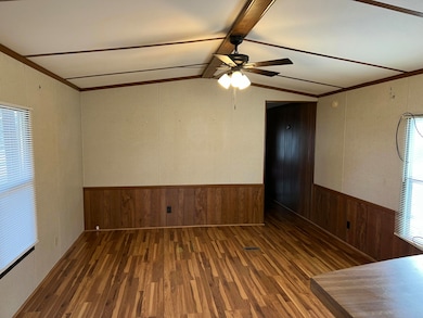
About This Home
Fantastic opportunity to purchase a cashflowing trailer home on a fantastic lot, in a beautiful scenic setting! Over an acre of cleared and serene land, overlooking pasture lands and horse farms. The home makes $900/month in rent from current tenant. Purchase and continue renting for proven income, or move in yourself, or move the trailer and build your dream home in one of the most ideal settings imaginable!
Listing Agent
Horizon Sotheby's International Realty License #328562 Listed on: 12/08/2025

Property Details
Home Type
- Manufactured Home
Est. Annual Taxes
- $177
Year Built
- Built in 1991 | Remodeled
Lot Details
- 1.13 Acre Lot
- Property fronts a county road
- Level Lot
- Cleared Lot
Property Views
- Pasture
- Rural
Home Design
- Single Family Detached Home
- Manufactured Home
- Permanent Foundation
- Aluminum Roof
- Metal Siding
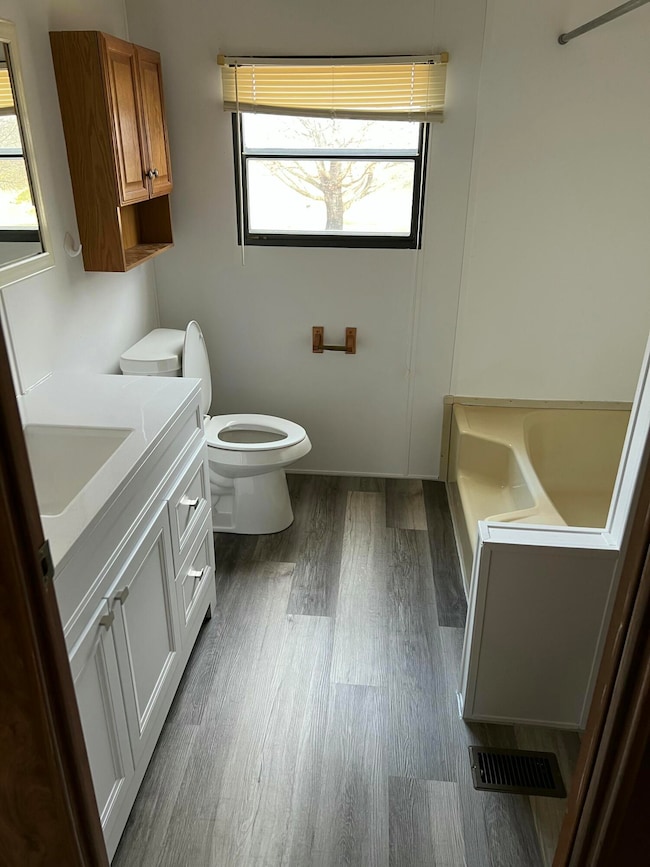
Interior Spaces
- 840 Sq Ft Home
- 1-Story Property
- Living Room
- Electric Range
- Laundry closet
Flooring
- Carpet
- Linoleum
- Vinyl
Bedrooms and Bathrooms
- 2 Bedrooms
- 1 Full Bathroom
Parking
- Gravel Driveway
- Paved Parking
Outdoor Features
- Covered Patio or Porch
- Outbuilding
Schools
- Rock Spring Elementary School
- Saddle Ridge Middle School
- Lafayette High School
Utilities
- Central Heating and Cooling System
- Electric Water Heater
- Septic Tank
Community Details
- No Home Owners Association
Listing and Financial Details
- Assessor Parcel Number Pb-9412
Map
Home Values in the Area
Average Home Value in this Area
Tax History
| Year | Tax Paid | Tax Assessment Tax Assessment Total Assessment is a certain percentage of the fair market value that is determined by local assessors to be the total taxable value of land and additions on the property. | Land | Improvement |
|---|---|---|---|---|
| 2025 | $182 | $9,308 | $8,314 | $994 |
| 2024 | $177 | $8,737 | $7,915 | $822 |
| 2023 | $80 | $4,362 | $0 | $4,362 |
| 2022 | $80 | $3,430 | $2,608 | $822 |
| 2021 | $175 | $3,293 | $2,608 | $685 |
| 2020 | $113 | $7,900 | $2,608 | $5,292 |
| 2019 | $114 | $6,212 | $2,608 | $3,604 |
| 2018 | $141 | $5,340 | $2,608 | $2,732 |
| 2017 | $130 | $5,340 | $2,608 | $2,732 |
| 2016 | $130 | $5,444 | $2,608 | $2,836 |
| 2015 | $130 | $8,833 | $5,316 | $3,517 |
| 2014 | $65 | $8,833 | $5,316 | $3,517 |
| 2013 | $141 | $8,832 | $5,316 | $3,516 |
Property History
| Date | Event | Price | List to Sale | Price per Sq Ft |
|---|---|---|---|---|
| 12/08/2025 12/08/25 | For Sale | $129,900 | -- | $155 / Sq Ft |
Purchase History
| Date | Type | Sale Price | Title Company |
|---|---|---|---|
| Warranty Deed | $15,000 | -- | |
| Deed | $5,700 | -- | |
| Deed | -- | -- |
Mortgage History
| Date | Status | Loan Amount | Loan Type |
|---|---|---|---|
| Open | $17,733 | New Conventional |
Source: Greater Chattanooga REALTORS®
MLS Number: 1525018
APN: 0353-019B
Disclaimer: Certain information contained herein is derived from information provided by parties other than Homes.com. All information provided is deemed reliable, but is not guaranteed to be accurate and should be independently verified.
![]() IDX information is provided exclusively for consumers’ personal, noncommercial use, that it may not be used for any purpose other than to identify prospective properties consumers may be interested in purchasing.
IDX information is provided exclusively for consumers’ personal, noncommercial use, that it may not be used for any purpose other than to identify prospective properties consumers may be interested in purchasing.
Data is deemed reliable but is not guaranteed accurate by the MLS.
Ten-X does not display the entire MLS of Chattanooga, Inc. database on this website. The listings of some real estate brokerage firms have been excluded. Some or all of the listings displayed may not belong to the firm whose website is being visited
Copyright© 2026 by Chattanooga Association of REALTORS®
- 23 Oak Meadow Dr
- 0 Georgia 95
- 1052 Huffman Rd
- 0 Van Dell Dr Unit 132760
- 505 Round Pond Rd
- 322 Chloe Dr
- 190 Chloe Dr
- 329 Pinewood Dr
- 0 Clyde Byrd Rd
- 0 Tarvin Rd Unit 1523862
- 450 Arnold Ln
- 1810 Ringgold Rd
- 218 Golden Oaks Dr
- 155 Ash Ln
- 1585 E Reed Rd
- 200 Ash Ln
- 287 E Teems Rd
- 1934 Round Pond Rd
- 15590 Alabama Hwy
- 322 Cannon Rd
- 4582 Highway N 27
- 56 Bell Rd
- 207 Napier St Unit 2
- 26 Enloe St
- 88 Battle Farm Ct
- 51 Lk Ter Dr
- 51 Lake Terrace Dr
- 3236 Shepard Dr Unit 3
- 506 Deck Dr
- 102 W 8th St
- 933 Mt Vernon Rd
- 410 Sam Love Rd
- 111 Wilder Rd
- 1945 Boss Rd
- 208 Wheeler Ave
- 2200 Park Canyon Dr
- 2111 Club Dr
- 804 N Tibbs Rd
- 1608 Crow Valley Rd
- 1912 Heathcliff Dr
Ask me questions while you tour the home.