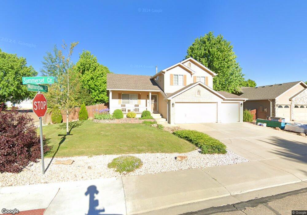
1315 Sommerset Cir Longmont, CO 80504
East Side NeighborhoodEstimated Value: $538,000 - $584,000
3
Beds
3
Baths
1,601
Sq Ft
$348/Sq Ft
Est. Value
About This Home
This home is located at 1315 Sommerset Cir, Longmont, CO 80504 and is currently estimated at $556,448, approximately $347 per square foot. 1315 Sommerset Cir is a home located in Boulder County with nearby schools including Fall River Elementary School, Trail Ridge Middle School, and Skyline High School.
Ownership History
Date
Name
Owned For
Owner Type
Purchase Details
Closed on
Aug 27, 2002
Sold by
Peterson Steven and Peterson Jeri L
Bought by
Latini Mario and Latini Stacy L
Current Estimated Value
Home Financials for this Owner
Home Financials are based on the most recent Mortgage that was taken out on this home.
Original Mortgage
$192,000
Outstanding Balance
$78,036
Interest Rate
5.87%
Estimated Equity
$478,412
Purchase Details
Closed on
Jul 15, 1998
Sold by
Fox Ronald C and Fox Frances H
Bought by
Peterson Steve and Peterson Jeri L
Home Financials for this Owner
Home Financials are based on the most recent Mortgage that was taken out on this home.
Original Mortgage
$148,000
Interest Rate
7.09%
Purchase Details
Closed on
Jul 1, 1997
Sold by
Melody Homes Inc
Bought by
Fox Ronald C
Create a Home Valuation Report for This Property
The Home Valuation Report is an in-depth analysis detailing your home's value as well as a comparison with similar homes in the area
Home Values in the Area
Average Home Value in this Area
Purchase History
| Date | Buyer | Sale Price | Title Company |
|---|---|---|---|
| Latini Mario | $240,000 | First American Heritage Titl | |
| Peterson Steve | $185,000 | -- | |
| Fox Ronald C | $160,195 | Land Title |
Source: Public Records
Mortgage History
| Date | Status | Borrower | Loan Amount |
|---|---|---|---|
| Open | Latini Mario | $192,000 | |
| Previous Owner | Peterson Steve | $148,000 |
Source: Public Records
Tax History Compared to Growth
Tax History
| Year | Tax Paid | Tax Assessment Tax Assessment Total Assessment is a certain percentage of the fair market value that is determined by local assessors to be the total taxable value of land and additions on the property. | Land | Improvement |
|---|---|---|---|---|
| 2025 | $3,120 | $33,726 | $8,913 | $24,813 |
| 2024 | $3,120 | $33,726 | $8,913 | $24,813 |
| 2023 | $3,078 | $32,622 | $9,829 | $26,478 |
| 2022 | $2,708 | $27,362 | $7,395 | $19,967 |
| 2021 | $2,743 | $28,150 | $7,608 | $20,542 |
| 2020 | $2,470 | $25,425 | $6,578 | $18,847 |
| 2019 | $2,431 | $25,425 | $6,578 | $18,847 |
| 2018 | $2,182 | $22,975 | $6,624 | $16,351 |
| 2017 | $2,153 | $25,400 | $7,323 | $18,077 |
| 2016 | $2,003 | $20,959 | $8,040 | $12,919 |
| 2015 | $1,909 | $16,915 | $3,900 | $13,015 |
| 2014 | $1,580 | $16,915 | $3,900 | $13,015 |
Source: Public Records
Map
Nearby Homes
- 1219 Cedarwood Dr
- 1290 Fall River Cir
- 1201 Trout Creek Cir
- 1208 Monarch Dr
- 1504 Pinewood Ct
- 1419 Red Mountain Dr Unit 15
- 1419 Red Mountain Dr Unit 116
- 1506 Crestwood Cir
- 1624 Golden Bear Dr
- 1245 Trail Ridge Rd
- 1426 Whitehall Dr Unit B
- 829 Independence Dr
- 1404 Whitehall Dr Unit C
- 330 High Point Dr Unit 104
- 1458 Ajax Way
- 1503 Prairie Hawk Dr
- 12027 Saint Vrain Rd
- 1405 Rustic Dr
- 1430 Bluefield Ave
- 836 Windflower Dr
- 1319 Sommerset Cir
- 1310 Monarch Dr
- 1314 Monarch Dr
- 1323 Sommerset Cir
- 1415 Morningside Dr
- 1426 Morningside Dr
- 1411 Morningside Dr
- 1419 Morningside Dr
- 1318 Monarch Dr
- 1334 Sommerset Cir
- 1423 Morningside Dr
- 1327 Sommerset Cir
- 1430 Morningside Dr
- 1330 Terrace Dr
- 1307 Monarch Dr
- 1303 Monarch Dr
- 1311 Monarch Dr
- 1322 Monarch Dr
- 1427 Morningside Dr
- 1334 Terrace Dr