Estimated Value: $478,000 - $609,000
4
Beds
3
Baths
1,695
Sq Ft
$315/Sq Ft
Est. Value
About This Home
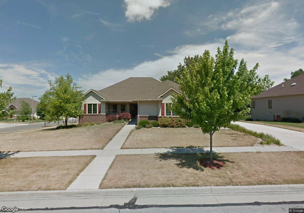
This home is located at 1317 Kinyon Cir, Ames, IA 50010 and is currently estimated at $533,235, approximately $314 per square foot. 1317 Kinyon Cir is a home located in Story County with nearby schools including Gilbert Elementary School, Gilbert Intermediate School, and Gilbert Middle School.
Ownership History
Date
Name
Owned For
Owner Type
Purchase Details
Closed on
Jun 26, 2023
Sold by
Rippetoe Joseph K and Rippetoe Martha Ann
Bought by
Joseph K Rippetoe 2023 Trust and Martha A Atkins 2023 Trust
Current Estimated Value
Purchase Details
Closed on
May 24, 2017
Sold by
Clayton Shaun Wade and Clayton Diana Lynn
Bought by
Rippetoe Joseph K and Atkins Martha Ann
Purchase Details
Closed on
Aug 2, 2012
Sold by
Pitts Kerry B and Pitts Kimberlee
Bought by
Clayton Shaun Wade and Clayton Diana Lynn
Home Financials for this Owner
Home Financials are based on the most recent Mortgage that was taken out on this home.
Original Mortgage
$274,000
Interest Rate
2.37%
Mortgage Type
Adjustable Rate Mortgage/ARM
Create a Home Valuation Report for This Property
The Home Valuation Report is an in-depth analysis detailing your home's value as well as a comparison with similar homes in the area
Home Values in the Area
Average Home Value in this Area
Purchase History
| Date | Buyer | Sale Price | Title Company |
|---|---|---|---|
| Joseph K Rippetoe 2023 Trust | -- | None Listed On Document | |
| Rippetoe Joseph K | $380,000 | None Available | |
| Clayton Shaun Wade | $342,500 | None Available |
Source: Public Records
Mortgage History
| Date | Status | Borrower | Loan Amount |
|---|---|---|---|
| Previous Owner | Clayton Shaun Wade | $274,000 |
Source: Public Records
Tax History Compared to Growth
Tax History
| Year | Tax Paid | Tax Assessment Tax Assessment Total Assessment is a certain percentage of the fair market value that is determined by local assessors to be the total taxable value of land and additions on the property. | Land | Improvement |
|---|---|---|---|---|
| 2025 | $7,670 | $553,700 | $123,100 | $430,600 |
| 2024 | $7,404 | $492,400 | $92,500 | $399,900 |
| 2023 | $6,638 | $492,400 | $92,500 | $399,900 |
| 2022 | $6,538 | $369,800 | $92,500 | $277,300 |
| 2021 | $6,832 | $369,800 | $92,500 | $277,300 |
| 2020 | $6,898 | $364,300 | $91,100 | $273,200 |
| 2019 | $6,898 | $364,300 | $91,100 | $273,200 |
| 2018 | $7,112 | $364,300 | $91,100 | $273,200 |
| 2017 | $7,112 | $364,300 | $91,100 | $273,200 |
| 2016 | $7,288 | $370,300 | $68,400 | $301,900 |
| 2015 | $7,288 | $370,300 | $68,400 | $301,900 |
| 2014 | $6,752 | $346,400 | $64,000 | $282,400 |
Source: Public Records
Map
Nearby Homes
- 3917 Fletcher Ct
- 3814 Brookdale Ave
- 2003 Polk Dr
- 3500 Grand Ave
- 2133 Polk Dr
- 2425 Dalton Cir
- 1636 Johnson St
- 532 W Riverside Rd
- 0 Hyde Ave
- 2403 Clayton Dr
- 1216 26th St
- 4882 Copperstone Dr
- 2516 Somerset Dr
- 2734 Clayton Dr
- 2511 Bristol Dr Unit 204
- 435 25th St
- 3701 Ashton Dr
- 2627 Stange Rd
- 5007 Skycrest Dr
- 2112 Furman Dr