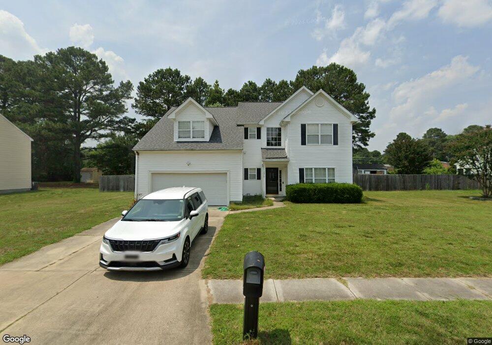
1317 Pheasant Cir Suffolk, VA 23434
Holy Neck NeighborhoodEstimated Value: $412,000 - $435,000
4
Beds
3
Baths
2,200
Sq Ft
$193/Sq Ft
Est. Value
About This Home
This home is located at 1317 Pheasant Cir, Suffolk, VA 23434 and is currently estimated at $424,558, approximately $192 per square foot. 1317 Pheasant Cir is a home located in Suffolk City with nearby schools including Kilby Shores Elementary School, King's Fork Middle School, and Lakeland High School.
Ownership History
Date
Name
Owned For
Owner Type
Purchase Details
Closed on
Aug 25, 2016
Sold by
Hopper Samjj and Hopper Lori M
Bought by
Perez Jonathan S
Current Estimated Value
Home Financials for this Owner
Home Financials are based on the most recent Mortgage that was taken out on this home.
Original Mortgage
$240,052
Outstanding Balance
$192,052
Interest Rate
3.48%
Mortgage Type
VA
Estimated Equity
$232,506
Create a Home Valuation Report for This Property
The Home Valuation Report is an in-depth analysis detailing your home's value as well as a comparison with similar homes in the area
Home Values in the Area
Average Home Value in this Area
Purchase History
| Date | Buyer | Sale Price | Title Company |
|---|---|---|---|
| Perez Jonathan S | $235,000 | Priority Title & Escrow Llc |
Source: Public Records
Mortgage History
| Date | Status | Borrower | Loan Amount |
|---|---|---|---|
| Open | Perez Jonathan S | $240,052 |
Source: Public Records
Tax History Compared to Growth
Tax History
| Year | Tax Paid | Tax Assessment Tax Assessment Total Assessment is a certain percentage of the fair market value that is determined by local assessors to be the total taxable value of land and additions on the property. | Land | Improvement |
|---|---|---|---|---|
| 2024 | $4,816 | $394,600 | $75,000 | $319,600 |
| 2023 | $4,615 | $387,800 | $75,000 | $312,800 |
| 2022 | $3,808 | $349,400 | $75,000 | $274,400 |
| 2021 | $3,209 | $289,100 | $64,400 | $224,700 |
| 2020 | $3,038 | $273,700 | $64,400 | $209,300 |
| 2019 | $2,951 | $265,900 | $64,400 | $201,500 |
| 2018 | $2,921 | $267,100 | $64,400 | $202,700 |
| 2017 | $2,690 | $251,400 | $64,400 | $187,000 |
| 2016 | $2,690 | $251,400 | $64,400 | $187,000 |
| 2015 | $1,363 | $243,600 | $64,400 | $179,200 |
| 2014 | $1,363 | $243,600 | $64,400 | $179,200 |
Source: Public Records
Map
Nearby Homes
- 201 Turlington Rd
- 1510 Brittle Dr
- 506 Deer Run Ct
- 510 Boxwood Ct
- 4035 Brians Ln
- 2001 Carroll Brinkley Way
- 2007 Carroll Brinkley Way
- 2011 Carroll Brinkley Way
- 68AC Manning Rd
- GALEN Plan at Brewers Meadows South
- HAYDEN Plan at Brewers Meadows South
- SALEM Plan at Brewers Meadows South
- PENWELL Plan at Brewers Meadows South
- HANOVER Plan at Brewers Meadows South
- 4040 Brians Ln
- 4042 Brians Ln
- 4048 Brians Ln
- 4043 Brians Ln
- 4045 Brians Ln
- 116 Grove Ave
- 1319 Pheasant Cir
- 1315 Pheasant Cir
- 1316 Pheasant Cir
- 1318 Pheasant Cir
- 1314 Pheasant Cir
- 1313 Pheasant Cir
- 1320 Pheasant Cir
- 1310 Pheasant Cir
- 1311 Pheasant Cir
- 1323 Pheasant Cir
- 1322 Pheasant Cir
- 1401 Goose Creek Ln
- 1403 Goose Creek Ln
- 241 Kilby Shores Dr
- 241 Kilby Shores Dr
- 1405 Goose Creek Ln
- 1330 Pheasant Cir
- 1309 Pheasant Cir
- 243 Kilby Shores Dr
- 1307 Pheasant Cir