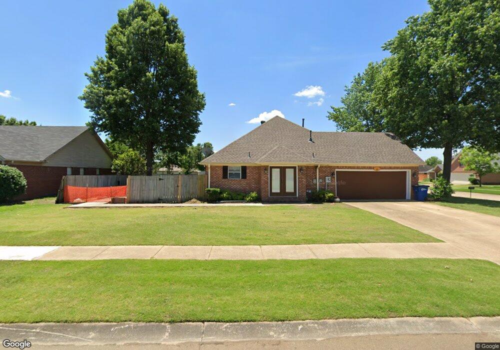
1317 Richland Dr West Memphis, AR 72301
Estimated Value: $279,000 - $305,000
3
Beds
2
Baths
2,021
Sq Ft
$144/Sq Ft
Est. Value
About This Home
This home is located at 1317 Richland Dr, West Memphis, AR 72301 and is currently estimated at $291,833, approximately $144 per square foot. 1317 Richland Dr is a home located in Crittenden County with nearby schools including Richland Elementary School, West Junior High School, and The Academies of West Memphis Charter School.
Ownership History
Date
Name
Owned For
Owner Type
Purchase Details
Closed on
Apr 26, 2019
Sold by
Zwiers Darrel L and Zwiers Lourdes
Bought by
Price Anthony Edward and Price Victoria A
Current Estimated Value
Home Financials for this Owner
Home Financials are based on the most recent Mortgage that was taken out on this home.
Original Mortgage
$194,900
Outstanding Balance
$170,293
Interest Rate
4.2%
Mortgage Type
New Conventional
Estimated Equity
$121,540
Purchase Details
Closed on
Jun 30, 1999
Sold by
Not Provided
Bought by
Snow Cabel L and Snow Nancy E
Create a Home Valuation Report for This Property
The Home Valuation Report is an in-depth analysis detailing your home's value as well as a comparison with similar homes in the area
Home Values in the Area
Average Home Value in this Area
Purchase History
| Date | Buyer | Sale Price | Title Company |
|---|---|---|---|
| Price Anthony Edward | $194,900 | Stewart Title | |
| Snow Cabel L | $142,000 | -- |
Source: Public Records
Mortgage History
| Date | Status | Borrower | Loan Amount |
|---|---|---|---|
| Open | Price Anthony Edward | $194,900 |
Source: Public Records
Tax History Compared to Growth
Tax History
| Year | Tax Paid | Tax Assessment Tax Assessment Total Assessment is a certain percentage of the fair market value that is determined by local assessors to be the total taxable value of land and additions on the property. | Land | Improvement |
|---|---|---|---|---|
| 2025 | $2,062 | $66,289 | $6,200 | $60,089 |
| 2024 | $1,580 | $43,350 | $6,200 | $37,150 |
| 2023 | $1,655 | $43,350 | $6,200 | $37,150 |
| 2022 | $1,705 | $43,350 | $6,200 | $37,150 |
| 2021 | $1,705 | $43,350 | $6,200 | $37,150 |
| 2020 | $1,964 | $43,350 | $6,200 | $37,150 |
| 2019 | $1,283 | $33,950 | $6,160 | $27,790 |
| 2018 | $1,026 | $33,950 | $6,160 | $27,790 |
| 2017 | $1,026 | $33,950 | $6,160 | $27,790 |
| 2016 | $1,026 | $33,950 | $6,160 | $27,790 |
| 2015 | $1,039 | $33,950 | $6,160 | $27,790 |
| 2014 | $1,099 | $35,430 | $6,160 | $29,270 |
Source: Public Records
Map
Nearby Homes
- 1108 Richland Cove
- 1405 Ashwood Cir
- 1409 Ashwood Cir
- 1302 Windover Ln
- 1002 Clement Rd
- 1042 W Roselawn Dr
- 1709 Pine Ridge Dr
- 1017 Mayberry Cove
- 1500 W Barton Ave
- 1106 W Barton Ave
- 909 Rosewood Dr
- 1505 Evergreen Dr
- 823 S Roselawn Dr
- 1103 Oakdale Dr
- 406 Cedar Chase Dr
- 808 Dover Rd
- 1105 Cherry Ln
- 805 Dover Rd
- 1108 Rich Rd
- 402 Brentwood Dr
- 1308 Colonial Dr
- 1315 Richland Dr
- 1306 Colonial Dr
- 1328 Richland Dr
- 1326 Richland Dr
- 1311 Colonial Dr
- 1309 Colonial Dr
- 1311 Richland Dr
- 1401 Colonial Dr
- 1322 Richland Dr
- 1307 Colonial Dr
- 1304 Colonial Dr
- 1106 Richland Cove
- 1403 Colonial Dr
- 1309 Richland Dr
- 1320 Richland Dr
- 1213 Wingate Dr
- 1211 Wingate Dr
- 1302 Colonial Dr
- 1405 Colonial Dr