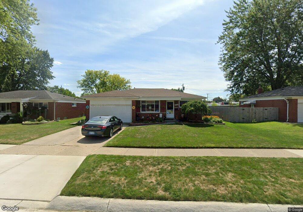
13170 Walter Ave Warren, MI 48088
Northeast Warren NeighborhoodEstimated Value: $231,000 - $240,000
3
Beds
2
Baths
1,101
Sq Ft
$214/Sq Ft
Est. Value
About This Home
This home is located at 13170 Walter Ave, Warren, MI 48088 and is currently estimated at $235,394, approximately $213 per square foot. 13170 Walter Ave is a home located in Macomb County with nearby schools including Warren Woods Tower High School, Frontier International Academy Elementary, and Warren Woods Christian School.
Ownership History
Date
Name
Owned For
Owner Type
Purchase Details
Closed on
Sep 21, 2022
Sold by
Kathryn J Barc Trust
Bought by
Barc Kathryn J
Current Estimated Value
Purchase Details
Closed on
May 31, 2018
Sold by
Bare Kathryn J
Bought by
Bare Kathryn J and Kathryn J Bare Trust
Purchase Details
Closed on
May 18, 2018
Sold by
Barc Richard R and Barc Betty J
Bought by
Barc Kathryn J
Purchase Details
Closed on
Oct 10, 1998
Sold by
Sage Raymond W
Bought by
Barc Richard R
Create a Home Valuation Report for This Property
The Home Valuation Report is an in-depth analysis detailing your home's value as well as a comparison with similar homes in the area
Home Values in the Area
Average Home Value in this Area
Purchase History
| Date | Buyer | Sale Price | Title Company |
|---|---|---|---|
| Barc Kathryn J | -- | -- | |
| Bare Kathryn J | -- | None Available | |
| Barc Kathryn J | -- | None Available | |
| Barc Richard R | $126,000 | -- |
Source: Public Records
Tax History
| Year | Tax Paid | Tax Assessment Tax Assessment Total Assessment is a certain percentage of the fair market value that is determined by local assessors to be the total taxable value of land and additions on the property. | Land | Improvement |
|---|---|---|---|---|
| 2025 | $3,069 | $111,560 | $0 | $0 |
| 2024 | $30 | $101,480 | $0 | $0 |
| 2023 | $2,830 | $98,030 | $0 | $0 |
| 2022 | $2,775 | $85,130 | $0 | $0 |
| 2021 | $2,723 | $78,000 | $0 | $0 |
| 2020 | $2,609 | $73,870 | $0 | $0 |
| 2019 | $2,493 | $48,760 | $0 | $0 |
| 2018 | $74 | $59,840 | $0 | $0 |
| 2017 | $2,382 | $53,900 | $11,790 | $42,110 |
| 2016 | $2,363 | $53,900 | $0 | $0 |
| 2015 | -- | $49,850 | $0 | $0 |
| 2013 | $2,283 | $46,130 | $0 | $0 |
Source: Public Records
Map
Nearby Homes
- 30032 Iroquois Dr
- 30045 Iroquois Dr
- 29820 Palomino Dr
- 12531 Common Rd
- 29143 Dover Ave
- 54765 Palomino Ave
- 30806 Ridgefield Ave
- 30829 Eiffel Ave
- 30139 Flanders Ave
- 30745 Iroquois Dr
- 29454 Scarborough Dr Unit 7
- 29105 Palomino Dr
- 29337 Roan Dr
- 29366 Wagner Dr
- 14135 Ivanhoe Dr
- 13209 E 13 Mile Rd
- 30955 Iroquois Dr
- 14066 Castle Ave
- 13342 Lutz Ave
- 29134 Bonnie Dr
- 13214 Walter Ave
- 13156 Walter Ave
- 13226 Walter Ave
- 13134 Walter Ave
- 13167 Walter Ave
- 13238 Walter Ave
- 13155 Walter Ave
- 13209 Walter Ave
- 13122 Walter Ave
- 13221 Walter Ave
- 13139 Walter Ave
- 29672 Dover Ave Unit Bldg-Unit
- 29672 Dover Ave
- 13233 Walter Ave
- 13127 Walter Ave
- 29665 Eiffel Ave
- 29660 Dover Ave
- 13254 Walter Ave
- 13110 Walter Ave
- 29653 Eiffel Ave
Your Personal Tour Guide
Ask me questions while you tour the home.