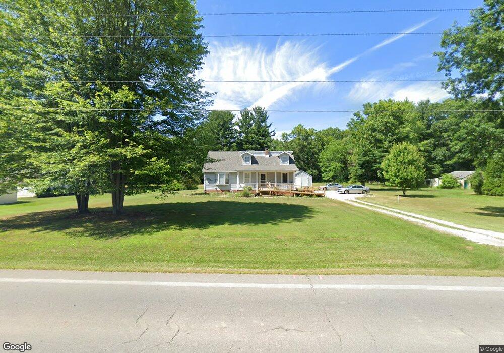
13181 Edison St NE Alliance, OH 44601
Estimated Value: $207,000 - $255,000
1
Bed
1
Bath
2,172
Sq Ft
$108/Sq Ft
Est. Value
About This Home
This home is located at 13181 Edison St NE, Alliance, OH 44601 and is currently estimated at $235,120, approximately $108 per square foot. 13181 Edison St NE is a home located in Stark County with nearby schools including Marlington High School and Regina Coeli/St Joseph School.
Ownership History
Date
Name
Owned For
Owner Type
Purchase Details
Closed on
Jun 28, 2021
Sold by
Lane Jason A
Bought by
Lane Melissa D
Current Estimated Value
Home Financials for this Owner
Home Financials are based on the most recent Mortgage that was taken out on this home.
Original Mortgage
$71,600
Outstanding Balance
$64,866
Interest Rate
2.8%
Mortgage Type
New Conventional
Estimated Equity
$170,254
Purchase Details
Closed on
Jun 29, 2004
Sold by
Lane Gloria J
Bought by
Lane Jason A and Lane Melissa D
Purchase Details
Closed on
Nov 16, 1994
Sold by
Yost Dorothy M
Bought by
Lane Gloria J and Lane Cecil C
Home Financials for this Owner
Home Financials are based on the most recent Mortgage that was taken out on this home.
Original Mortgage
$18,400
Interest Rate
8.91%
Mortgage Type
New Conventional
Create a Home Valuation Report for This Property
The Home Valuation Report is an in-depth analysis detailing your home's value as well as a comparison with similar homes in the area
Home Values in the Area
Average Home Value in this Area
Purchase History
| Date | Buyer | Sale Price | Title Company |
|---|---|---|---|
| Lane Melissa D | -- | Patriot Title Agency Inc | |
| Lane Jason A | -- | -- | |
| Lane Gloria J | $21,000 | -- |
Source: Public Records
Mortgage History
| Date | Status | Borrower | Loan Amount |
|---|---|---|---|
| Open | Lane Melissa D | $71,600 | |
| Closed | Lane Gloria J | $18,400 |
Source: Public Records
Tax History Compared to Growth
Tax History
| Year | Tax Paid | Tax Assessment Tax Assessment Total Assessment is a certain percentage of the fair market value that is determined by local assessors to be the total taxable value of land and additions on the property. | Land | Improvement |
|---|---|---|---|---|
| 2025 | -- | $65,040 | $11,660 | $53,380 |
| 2024 | -- | $65,040 | $11,660 | $53,380 |
| 2023 | $1,802 | $51,170 | $10,850 | $40,320 |
| 2022 | $1,809 | $51,170 | $10,850 | $40,320 |
| 2021 | $1,814 | $51,170 | $10,850 | $40,320 |
| 2020 | $1,723 | $43,300 | $9,380 | $33,920 |
| 2019 | $1,711 | $43,300 | $9,380 | $33,920 |
| 2018 | $1,714 | $43,300 | $9,380 | $33,920 |
| 2017 | $1,723 | $40,750 | $4,970 | $35,780 |
| 2016 | $1,723 | $40,750 | $4,970 | $35,780 |
| 2015 | $1,193 | $29,620 | $5,150 | $24,470 |
| 2014 | $1,127 | $25,560 | $4,450 | $21,110 |
| 2013 | $560 | $25,560 | $4,450 | $21,110 |
Source: Public Records
Map
Nearby Homes
- 13109 Edison St NE
- 11940 Freshley Ave NE
- 11480 Aebi Ave NE
- 12355 Edison St NE
- 12415 Snode St NE
- 12252 Snode St NE
- 0 Meadow St NE
- 0 Klinger Ave NE
- 14422 Sturbridge Rd NE
- 13334 Cindy St NE
- 0 Johnson Ave NE Unit 5142926
- 10666 Wilma Ave NE
- 13061 Beeson St NE
- 0 Homestead Ave NE
- 14723 Bolton St NE
- 000 Klinger Ave
- 13975 Greenbower St NE
- 0 Meadowbrook Ave
- 000 Meadowbrook Ave
- 432 Johnson Ave
- 13151 Edison St NE
- 13203 Edison St NE
- 13204 Edison St NE
- 13104 Edison St NE
- 13077 Edison St NE
- 13282 Edison St NE
- 9999 Atwater Ave NE
- 12121 Atwater Ave NE
- 13050 Edison St NE
- 13032 Edison St NE
- 13344 Edison St NE
- 13023 Edison St NE
- 13004 Edison St NE
- 12991 Edison St NE
- 12980 Edison St NE
- 12971 Edison St NE
- 12951 Edison St NE
- 12966 Edison St NE
- 12931 Edison St NE
- 12930 Edison St NE