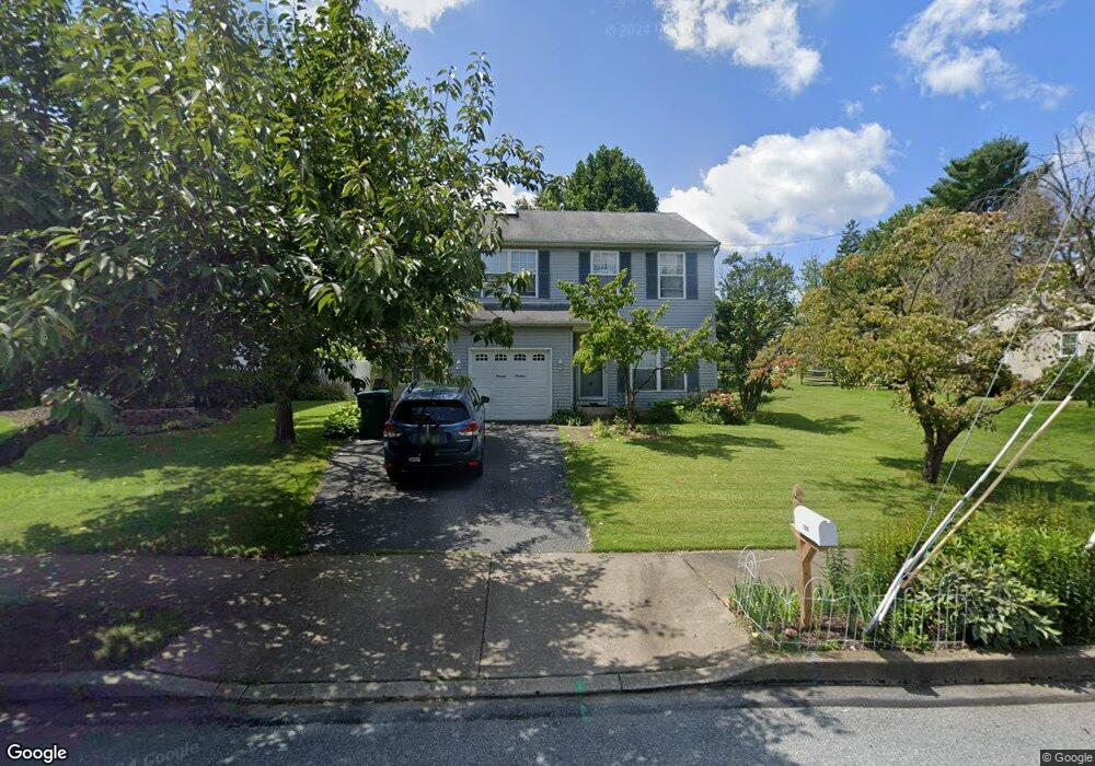
1319 Wayne St Easton, PA 18045
Estimated Value: $373,000 - $426,000
3
Beds
3
Baths
1,376
Sq Ft
$285/Sq Ft
Est. Value
About This Home
This home is located at 1319 Wayne St, Easton, PA 18045 and is currently estimated at $392,315, approximately $285 per square foot. 1319 Wayne St is a home located in Northampton County with nearby schools including Palmer Elementary School, Easton Area Middle School, and Easton Area High School.
Ownership History
Date
Name
Owned For
Owner Type
Purchase Details
Closed on
Dec 23, 2022
Sold by
Weiss Monica L
Bought by
Weiss Monica L and Weiss-Nolen Monica L
Current Estimated Value
Purchase Details
Closed on
Mar 4, 2003
Sold by
Jones William F
Bought by
Weiss Monica L
Home Financials for this Owner
Home Financials are based on the most recent Mortgage that was taken out on this home.
Original Mortgage
$139,200
Interest Rate
5.98%
Mortgage Type
New Conventional
Purchase Details
Closed on
Feb 1, 1993
Bought by
Jones William F
Create a Home Valuation Report for This Property
The Home Valuation Report is an in-depth analysis detailing your home's value as well as a comparison with similar homes in the area
Home Values in the Area
Average Home Value in this Area
Purchase History
| Date | Buyer | Sale Price | Title Company |
|---|---|---|---|
| Weiss Monica L | -- | -- | |
| Weiss Monica L | -- | None Listed On Document | |
| Weiss Monica L | $174,000 | -- | |
| Jones William F | $115,900 | -- |
Source: Public Records
Mortgage History
| Date | Status | Borrower | Loan Amount |
|---|---|---|---|
| Previous Owner | Weiss Monica L | $139,200 |
Source: Public Records
Tax History Compared to Growth
Tax History
| Year | Tax Paid | Tax Assessment Tax Assessment Total Assessment is a certain percentage of the fair market value that is determined by local assessors to be the total taxable value of land and additions on the property. | Land | Improvement |
|---|---|---|---|---|
| 2025 | $627 | $58,100 | $19,400 | $38,700 |
| 2024 | $5,149 | $58,100 | $19,400 | $38,700 |
| 2023 | $5,057 | $58,100 | $19,400 | $38,700 |
| 2022 | $4,981 | $58,100 | $19,400 | $38,700 |
| 2021 | $4,965 | $58,100 | $19,400 | $38,700 |
| 2020 | $4,962 | $58,100 | $19,400 | $38,700 |
| 2019 | $4,891 | $58,100 | $19,400 | $38,700 |
| 2018 | $4,808 | $58,100 | $19,400 | $38,700 |
| 2017 | $4,694 | $58,100 | $19,400 | $38,700 |
| 2016 | -- | $58,100 | $19,400 | $38,700 |
| 2015 | -- | $58,100 | $19,400 | $38,700 |
| 2014 | -- | $58,100 | $19,400 | $38,700 |
Source: Public Records
Map
Nearby Homes
- 6 Gold Rose Ln
- 604 Berks St
- 0 Stewart St
- 1701 Chain Dam Rd
- 2734 Tamlynn Ln
- 2463 Hillside Ave
- 1049 S 25th St
- 4 Middle Ct
- 30 Wilden Dr
- 2329 4th St
- 12 Kendon Dr
- 2246 2nd St
- 530 Milford St
- 0 S Greenwood Ave Unit 11 737666
- 317 Front St
- 3772 Fleetwood Dr
- 808 Miller St
- 53 Blenheim Dr
- 2439 Hay St
- 705 Sterlingworth Terrace