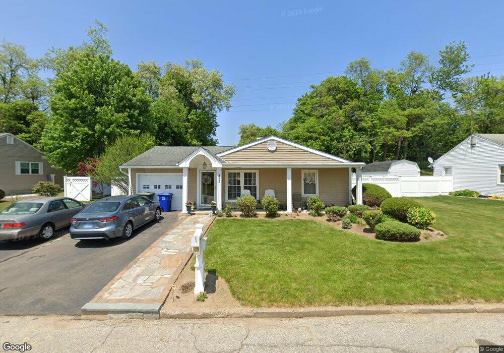
132 Bear Paw Rd Bridgeport, CT 06606
North End NeighborhoodEstimated Value: $377,000 - $456,000
3
Beds
1
Bath
1,372
Sq Ft
$311/Sq Ft
Est. Value
About This Home
This home is located at 132 Bear Paw Rd, Bridgeport, CT 06606 and is currently estimated at $426,784, approximately $311 per square foot. 132 Bear Paw Rd is a home located in Fairfield County with nearby schools including John Winthrop School, Central High School, and St Andrew School.
Ownership History
Date
Name
Owned For
Owner Type
Purchase Details
Closed on
Dec 4, 1998
Sold by
Lindwall Linda
Bought by
Smith Stephanie
Current Estimated Value
Purchase Details
Closed on
Apr 30, 1996
Sold by
Basham Park and Basham Elizabeth B
Bought by
Bousquet Linda E
Purchase Details
Closed on
Dec 19, 1989
Sold by
Watcke John
Bought by
Basham Park
Create a Home Valuation Report for This Property
The Home Valuation Report is an in-depth analysis detailing your home's value as well as a comparison with similar homes in the area
Home Values in the Area
Average Home Value in this Area
Purchase History
| Date | Buyer | Sale Price | Title Company |
|---|---|---|---|
| Smith Stephanie | $110,000 | -- | |
| Smith Stephanie | $110,000 | -- | |
| Bousquet Linda E | $88,900 | -- | |
| Bousquet Linda E | $88,900 | -- | |
| Basham Park | $130,000 | -- |
Source: Public Records
Mortgage History
| Date | Status | Borrower | Loan Amount |
|---|---|---|---|
| Open | Basham Park | $94,000 | |
| Closed | Basham Park | $93,000 | |
| Open | Basham Park | $151,000 |
Source: Public Records
Tax History Compared to Growth
Tax History
| Year | Tax Paid | Tax Assessment Tax Assessment Total Assessment is a certain percentage of the fair market value that is determined by local assessors to be the total taxable value of land and additions on the property. | Land | Improvement |
|---|---|---|---|---|
| 2025 | $6,773 | $155,870 | $74,600 | $81,270 |
| 2024 | $6,773 | $155,870 | $74,600 | $81,270 |
| 2023 | $6,773 | $155,870 | $74,600 | $81,270 |
| 2022 | $6,773 | $155,870 | $74,600 | $81,270 |
| 2021 | $6,773 | $155,870 | $74,600 | $81,270 |
| 2020 | $6,504 | $120,470 | $58,440 | $62,030 |
| 2019 | $6,504 | $120,470 | $58,440 | $62,030 |
| 2018 | $6,550 | $120,470 | $58,440 | $62,030 |
| 2017 | $6,550 | $120,470 | $58,440 | $62,030 |
| 2016 | $6,550 | $120,470 | $58,440 | $62,030 |
| 2015 | $5,424 | $128,540 | $57,520 | $71,020 |
| 2014 | $5,424 | $128,540 | $57,520 | $71,020 |
Source: Public Records
Map
Nearby Homes
- 394 Anton Dr
- 173 Anton Dr
- 64 Dobson St
- 65 Dobson St
- 50 Greenhouse Rd Unit 65D
- 50 Greenhouse Rd Unit 42C
- 2851 Old Town Rd
- 87 Oliver St
- 236 Edgemoor Rd Unit D
- 344 Cambridge St
- 90 Sequoia Rd
- 114 Oxford St
- 9 Patricia Rd Unit C
- 84 Oxford St
- 153 Seaver Cir
- 72 Herald Ave
- 66 Loftus Cir
- 265 Vincellette St
- 2998 Madison Ave Unit C
- 360 Vincellette St
- 116 Bear Paw Rd
- 150 Bear Paw Rd
- 131 Bear Paw Rd
- 147 Bear Paw Rd
- 102 Bear Paw Rd
- 165 Bear Paw Rd
- 115 Bear Paw Rd
- 105 Bear Paw Rd
- 88 Bear Paw Rd
- 108 Indian Field Rd
- 177 Bear Paw Rd
- 15 Travis Dr
- 138 Indian Field Rd
- 92 Indian Field Rd
- 83 Bear Paw Rd
- 194 Bear Paw Rd
- 74 Bear Paw Rd
- 191 Bear Paw Rd
- 152 Indian Field Rd