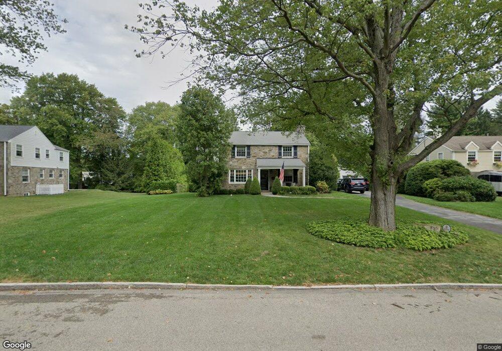
132 Browning Ln Bryn Mawr, PA 19010
Rosemont NeighborhoodEstimated Value: $1,539,000 - $1,867,000
4
Beds
3
Baths
3,354
Sq Ft
$489/Sq Ft
Est. Value
About This Home
This home is located at 132 Browning Ln, Bryn Mawr, PA 19010 and is currently estimated at $1,638,569, approximately $488 per square foot. 132 Browning Ln is a home located in Delaware County with nearby schools including Radnor El School, Radnor Middle School, and Radnor Senior High School.
Ownership History
Date
Name
Owned For
Owner Type
Purchase Details
Closed on
Apr 16, 1999
Sold by
Sellers Frank R S and Sellers Suzanne Dubarry
Bought by
Kirkpatrick Jack H and Kirkpatrick Beverly G
Current Estimated Value
Home Financials for this Owner
Home Financials are based on the most recent Mortgage that was taken out on this home.
Original Mortgage
$175,000
Outstanding Balance
$44,239
Interest Rate
7.02%
Estimated Equity
$1,594,330
Create a Home Valuation Report for This Property
The Home Valuation Report is an in-depth analysis detailing your home's value as well as a comparison with similar homes in the area
Home Values in the Area
Average Home Value in this Area
Purchase History
| Date | Buyer | Sale Price | Title Company |
|---|---|---|---|
| Kirkpatrick Jack H | $415,000 | Commonwealth Land Title Ins |
Source: Public Records
Mortgage History
| Date | Status | Borrower | Loan Amount |
|---|---|---|---|
| Open | Kirkpatrick Jack H | $175,000 |
Source: Public Records
Tax History Compared to Growth
Tax History
| Year | Tax Paid | Tax Assessment Tax Assessment Total Assessment is a certain percentage of the fair market value that is determined by local assessors to be the total taxable value of land and additions on the property. | Land | Improvement |
|---|---|---|---|---|
| 2025 | $16,265 | $804,460 | $217,280 | $587,180 |
| 2024 | $16,265 | $804,460 | $217,280 | $587,180 |
| 2023 | $15,620 | $804,460 | $217,280 | $587,180 |
| 2022 | $15,450 | $804,460 | $217,280 | $587,180 |
| 2021 | $24,816 | $804,460 | $217,280 | $587,180 |
| 2020 | $14,177 | $407,520 | $124,020 | $283,500 |
| 2019 | $13,777 | $407,520 | $124,020 | $283,500 |
| 2018 | $13,506 | $407,520 | $0 | $0 |
| 2017 | $13,224 | $407,520 | $0 | $0 |
| 2016 | $2,236 | $407,520 | $0 | $0 |
| 2015 | $2,282 | $407,520 | $0 | $0 |
| 2014 | $2,236 | $407,520 | $0 | $0 |
Source: Public Records
Map
Nearby Homes
- 219 S Ithan Ave
- 7 Lockwood Ln
- 4 Lockwood Ln
- 8 Lockwood Ln
- 3 Lockwood Ln
- 200 S Ithan Ave
- 15 Lockwood Ln
- 12 Lockwood Ln
- 117 Debaran Ln
- 406 Barclay Rd
- 221 Fitzwilliams Rd
- 223 Fitzwilliams Rd
- 329 Williams Rd
- 13 Barley Cone Ln
- 12 Lowrys Ln
- 168 Woodstock Rd
- 4 Lowrys Ln
- 109 Willowburn Rd
- 200 Hilldale Rd
- 1030 E Lancaster Ave Unit 923
- 130 Browning Ln
- 134 Browning Ln
- 136 Browning Ln
- 116 Browning Ln
- 128 Browning Ln
- 114 Browning Ln
- 118 Browning Ln
- 112 Browning Ln
- 0 Boxwood Rd Unit 7229565
- 0 Boxwood Rd Unit 7116775
- 133 Browning Ln
- 135 Browning Ln
- 138 Browning Ln
- 120 Browning Ln
- 131 Browning Ln
- 110 Browning Ln
- 137 Browning Ln
- 129 Browning Ln
- 140 Browning Ln
- 139 Browning Ln