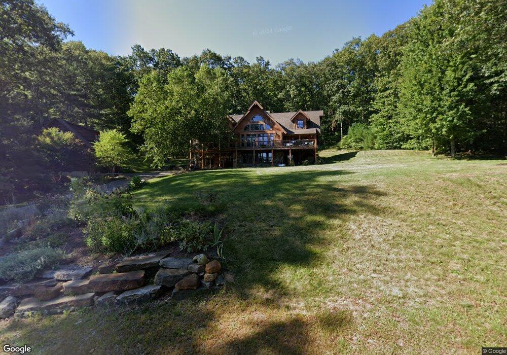
132 New City Rd Stafford Springs, CT 06076
Stafford NeighborhoodEstimated Value: $531,000 - $662,000
2
Beds
3
Baths
2,680
Sq Ft
$229/Sq Ft
Est. Value
About This Home
This home is located at 132 New City Rd, Stafford Springs, CT 06076 and is currently estimated at $613,192, approximately $228 per square foot. 132 New City Rd is a home located in Tolland County with nearby schools including Stafford Elementary School, Stafford Middle School, and Stafford High School.
Ownership History
Date
Name
Owned For
Owner Type
Purchase Details
Closed on
Oct 26, 2000
Sold by
Kiehm Robert
Bought by
Agostino Joseph and Agostino Linda
Current Estimated Value
Create a Home Valuation Report for This Property
The Home Valuation Report is an in-depth analysis detailing your home's value as well as a comparison with similar homes in the area
Home Values in the Area
Average Home Value in this Area
Purchase History
| Date | Buyer | Sale Price | Title Company |
|---|---|---|---|
| Agostino Joseph | $30,000 | -- |
Source: Public Records
Mortgage History
| Date | Status | Borrower | Loan Amount |
|---|---|---|---|
| Open | Agostino Joseph | $280,000 | |
| Closed | Agostino Joseph | $25,000 | |
| Closed | Agostino Joseph | $228,000 | |
| Closed | Agostino Joseph | $190,000 |
Source: Public Records
Tax History Compared to Growth
Tax History
| Year | Tax Paid | Tax Assessment Tax Assessment Total Assessment is a certain percentage of the fair market value that is determined by local assessors to be the total taxable value of land and additions on the property. | Land | Improvement |
|---|---|---|---|---|
| 2025 | $16,575 | $270,270 | $35,700 | $234,570 |
| 2024 | $10,430 | $270,270 | $35,700 | $234,570 |
| 2023 | $9,935 | $270,270 | $35,700 | $234,570 |
| 2022 | $9,670 | $270,270 | $35,700 | $234,570 |
| 2021 | $9,441 | $270,270 | $35,700 | $234,570 |
| 2020 | $3,683 | $264,950 | $41,510 | $223,440 |
| 2019 | $8,998 | $257,600 | $41,510 | $216,090 |
| 2018 | $8,825 | $257,600 | $41,510 | $216,090 |
| 2017 | $8,740 | $257,600 | $41,510 | $216,090 |
| 2016 | $8,632 | $257,600 | $41,510 | $216,090 |
| 2015 | $8,632 | $252,770 | $38,010 | $214,760 |
| 2014 | $8,349 | $252,770 | $38,010 | $214,760 |
Source: Public Records
Map
Nearby Homes
- 31 Lake Shore Blvd
- 237 Upper Rd
- 41 Delphi Rd
- 151 Wales Rd
- 89 Bradway Rd
- 174 Stafford St
- 3 Hemlock Cir
- 67 Willow Ln
- 107 Hydeville Rd
- 46 Dogwood Ln
- 21 Ash Ln
- 74 Crooked S Rd
- 28 Fluery Dr
- 375 Stickney Hill Rd
- 105 Leonard Rd
- 8 South Rd Unit W86
- 8 South Rd Unit WW4
- 8 South Rd Unit R80
- 8 South Rd Unit R29
- 192 Leonard Rd
- 128 New City Rd
- 136 New City Rd
- 120 New City Rd
- 144 New City Rd
- 112 New City Rd
- 108 New City Rd
- 113 New City Rd
- 107 New City Rd
- 104 New City Rd
- 96 New City Rd
- 76 New City Rd
- 85 New City Rd
- 120 Sartori Rd
- 72 New City Rd
- 93 New City Rd
- 68 New City Rd
- 7 Virginia Ln
- 9 Virginia Ln
- 53 Wales Rd
- 196 New City Rd