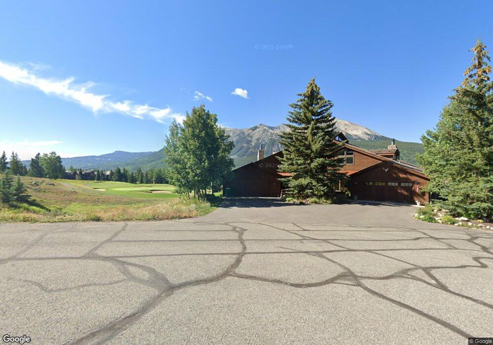
132 Par Ln Crested Butte, CO 81224
Estimated Value: $1,681,000 - $1,893,276
3
Beds
3
Baths
2,432
Sq Ft
$745/Sq Ft
Est. Value
About This Home
This home is located at 132 Par Ln, Crested Butte, CO 81224 and is currently estimated at $1,812,319, approximately $745 per square foot. 132 Par Ln is a home located in Gunnison County with nearby schools including Gunnison Elementary School, Crested Butte Community School, and Gunnison Middle School.
Ownership History
Date
Name
Owned For
Owner Type
Purchase Details
Closed on
Nov 15, 2022
Sold by
Defrates Family Trust
Bought by
Williamson Property Holdings Llc
Current Estimated Value
Purchase Details
Closed on
Oct 25, 1999
Sold by
Cox Thomas S
Bought by
Defrated Earl E
Purchase Details
Closed on
Dec 29, 1993
Purchase Details
Closed on
Aug 30, 1991
Create a Home Valuation Report for This Property
The Home Valuation Report is an in-depth analysis detailing your home's value as well as a comparison with similar homes in the area
Home Values in the Area
Average Home Value in this Area
Purchase History
| Date | Buyer | Sale Price | Title Company |
|---|---|---|---|
| Williamson Property Holdings Llc | $1,700,000 | Land Title | |
| Defrated Earl E | $465,000 | -- | |
| -- | $345,000 | -- | |
| -- | $375,000 | -- |
Source: Public Records
Tax History Compared to Growth
Tax History
| Year | Tax Paid | Tax Assessment Tax Assessment Total Assessment is a certain percentage of the fair market value that is determined by local assessors to be the total taxable value of land and additions on the property. | Land | Improvement |
|---|---|---|---|---|
| 2024 | $7,832 | $106,330 | $14,300 | $92,030 |
| 2023 | $7,832 | $102,640 | $13,800 | $88,840 |
| 2022 | $5,501 | $61,610 | $9,310 | $52,300 |
| 2021 | $5,064 | $63,390 | $9,580 | $53,810 |
| 2020 | $4,180 | $49,660 | $8,040 | $41,620 |
| 2019 | $4,122 | $49,660 | $8,040 | $41,620 |
| 2018 | $3,819 | $42,460 | $8,750 | $33,710 |
| 2017 | $3,845 | $42,460 | $8,750 | $33,710 |
| 2016 | $3,437 | $39,530 | $9,950 | $29,580 |
| 2015 | $1,651 | $39,530 | $9,950 | $29,580 |
| 2014 | $1,651 | $34,140 | $9,050 | $25,090 |
Source: Public Records
Map
Nearby Homes
- 315 Par Ln
- 350 Country Club Dr Unit 217A
- 350 Country Club Dr Unit 218A
- 350 Country Club Dr Unit 402A
- 412 Ridge Rd
- 402 Eagle Ln
- 262 Larkspur Loop
- 365 Larkspur Loop
- 166 & 168 Coyote Cir
- 115 Larkspur Loop
- 434 Country Club Dr
- 42 Lexie Ct
- 0 Tbd Saddle Ridge Rd
- 491 Slate River Dr
- 64 Vista Ct
- 168 W Silver Sage Dr
- 618 Country Club Dr
- 88 Vista Ct
- 179 Aspen Ln
- 1665 Skyland Dr
- 20 Par Ln Unit 1
- 10 Par Ln
- 32 Par Ln
- 32 Par Ln Unit Skyland
- 2100 Skyland Dr
- H Avenue
- 89 Par Ln
- 89 Par Ln
- 0 Fairway Dr Skyland Unit LOT S92 SKYLAND INIT
- 300 Skyland Dr Unit 2, The Boulders Sout
- 300 Skyland Dr Unit 2
- 375 Skyland Dr
- 375 Skyland Dr Unit Lot D-6 Skyland Init
- 375 Skyland Dr Unit Lot D-6 Skyland Init
- 375 Skyland Dr Unit Lot D-6 Skyland
- 139 Par Ln
- 182 Par Ln
- 350 Skyland Dr
- 350 Skyland Dr Unit 301-A
- 350 Skyland Dr