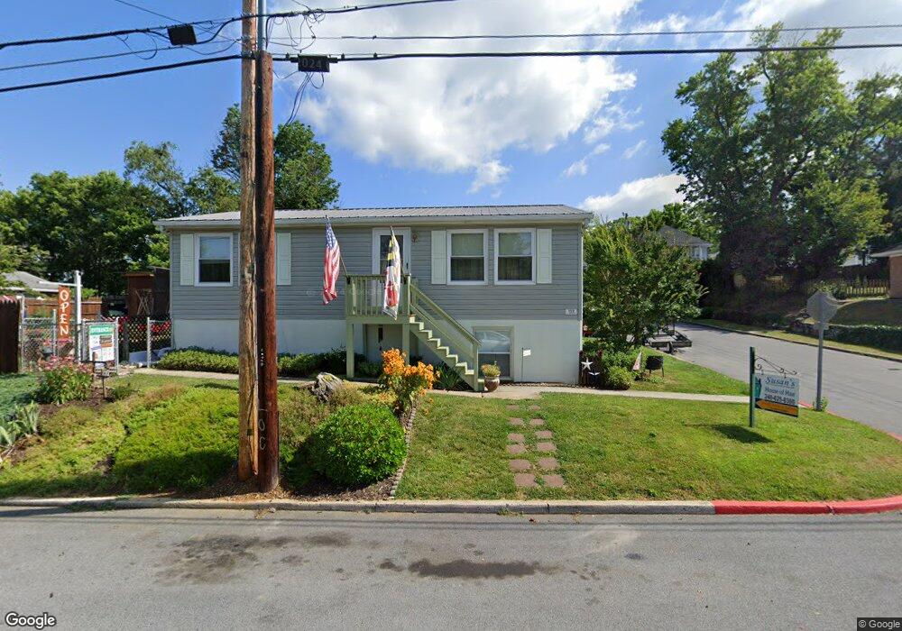
132 S High St Funkstown, MD 21734
Estimated Value: $186,827 - $251,000
--
Bed
--
Bath
864
Sq Ft
$265/Sq Ft
Est. Value
About This Home
This home is located at 132 S High St, Funkstown, MD 21734 and is currently estimated at $228,957, approximately $264 per square foot. 132 S High St is a home located in Washington County with nearby schools including Ruth Ann Monroe Primary School, Eastern Elementary School, and E. Russell Hicks Middle School.
Ownership History
Date
Name
Owned For
Owner Type
Purchase Details
Closed on
Sep 1, 2004
Sold by
Sarber Christopher M
Bought by
Graybill Nathen M and Graybill Susan E
Current Estimated Value
Purchase Details
Closed on
Apr 8, 2003
Sold by
Conley Dale E and Conley Minnie P
Bought by
Sarber Christopher M and Klick Megan E
Create a Home Valuation Report for This Property
The Home Valuation Report is an in-depth analysis detailing your home's value as well as a comparison with similar homes in the area
Home Values in the Area
Average Home Value in this Area
Purchase History
| Date | Buyer | Sale Price | Title Company |
|---|---|---|---|
| Graybill Nathen M | $145,000 | -- | |
| Sarber Christopher M | $123,500 | -- |
Source: Public Records
Mortgage History
| Date | Status | Borrower | Loan Amount |
|---|---|---|---|
| Closed | Sarber Christopher M | -- |
Source: Public Records
Tax History Compared to Growth
Tax History
| Year | Tax Paid | Tax Assessment Tax Assessment Total Assessment is a certain percentage of the fair market value that is determined by local assessors to be the total taxable value of land and additions on the property. | Land | Improvement |
|---|---|---|---|---|
| 2025 | $1,244 | $169,367 | $0 | $0 |
| 2024 | $1,244 | $156,500 | $47,500 | $109,000 |
| 2023 | $1,182 | $142,933 | $0 | $0 |
| 2022 | $1,114 | $129,367 | $0 | $0 |
| 2021 | $1,058 | $115,800 | $47,500 | $68,300 |
| 2020 | $1,058 | $113,700 | $0 | $0 |
| 2019 | $1,043 | $111,600 | $0 | $0 |
| 2018 | $1,024 | $109,500 | $54,600 | $54,900 |
| 2017 | $1,018 | $108,900 | $0 | $0 |
| 2016 | -- | $108,300 | $0 | $0 |
| 2015 | $988 | $107,700 | $0 | $0 |
| 2014 | $988 | $107,700 | $0 | $0 |
Source: Public Records
Map
Nearby Homes
- 24 W Cemetery St
- 104 Bethlehem Ct
- 1432 Oak Ridge Place
- 12.3 AC Southern Blvd
- 701 Beaver Creek Rd
- 90 Charlotte St
- 27 Hebb Rd
- 315 Emmert Rd
- 1203 Peppercorn Dr
- 206 Winding Oak Dr
- 1619 Dual Hwy
- 628 Knightsbridge Dr
- 202 S Fork Dr
- 622 Knightsbridge Dr
- 1747 Edgewood Hill Cir Unit 201
- 10378 Lantern Ln
- 147 Buttercup Dr
- 0 Kenly Ave
- 1635 Edgewood Place Unit 2
- 1631 Edgewood Place Unit 103
- 122 S High St
- 26 E Cemetery St
- 112 S High St
- 37 E Cemetery St
- 39 E Cemetery St
- 35 E Cemetery St
- 102 E Cemetery St
- 24 E Cemetery St
- 101 E Maple St
- 37 E Cemetery St
- 101 Maple St E
- 39 E Maple St
- 22 E Cemetery St
- 35 E Cemetery St
- 101 E Cemetery St
- 29 E Cemetery St
- 25 E Maple St
- 103 E Maple St
- 49 E Maple St
- 65 Herman Gaver Place