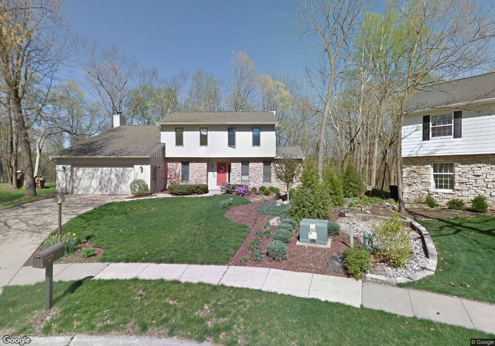
132 Tahoe Ct SE Cedar Rapids, IA 52403
Estimated Value: $364,909 - $460,000
5
Beds
4
Baths
2,737
Sq Ft
$147/Sq Ft
Est. Value
About This Home
This home is located at 132 Tahoe Ct SE, Cedar Rapids, IA 52403 and is currently estimated at $402,227, approximately $146 per square foot. 132 Tahoe Ct SE is a home located in Linn County with nearby schools including Erskine Elementary School, McKinley STEAM Academy, and George Washington High School.
Ownership History
Date
Name
Owned For
Owner Type
Purchase Details
Closed on
Jan 11, 2022
Sold by
Munro Charles S and Munro Melanie K
Bought by
Charles S Munro Trust
Current Estimated Value
Create a Home Valuation Report for This Property
The Home Valuation Report is an in-depth analysis detailing your home's value as well as a comparison with similar homes in the area
Home Values in the Area
Average Home Value in this Area
Purchase History
| Date | Buyer | Sale Price | Title Company |
|---|---|---|---|
| Charles S Munro Trust | -- | Shuttleworth & Ingersoll Plc |
Source: Public Records
Tax History Compared to Growth
Tax History
| Year | Tax Paid | Tax Assessment Tax Assessment Total Assessment is a certain percentage of the fair market value that is determined by local assessors to be the total taxable value of land and additions on the property. | Land | Improvement |
|---|---|---|---|---|
| 2025 | $5,662 | $365,100 | $65,700 | $299,400 |
| 2024 | $6,128 | $359,500 | $65,700 | $293,800 |
| 2023 | $6,128 | $346,100 | $65,700 | $280,400 |
| 2022 | $5,524 | $302,800 | $51,400 | $251,400 |
| 2021 | $5,690 | $279,000 | $51,400 | $227,600 |
| 2020 | $5,690 | $269,800 | $45,700 | $224,100 |
| 2019 | $5,568 | $270,100 | $45,700 | $224,400 |
| 2018 | $5,408 | $270,100 | $45,700 | $224,400 |
| 2017 | $5,303 | $257,500 | $45,700 | $211,800 |
| 2016 | $5,303 | $252,800 | $45,700 | $207,100 |
| 2015 | $5,715 | $271,937 | $45,711 | $226,226 |
| 2014 | $5,530 | $265,080 | $45,711 | $219,369 |
| 2013 | $5,264 | $265,080 | $45,711 | $219,369 |
Source: Public Records
Map
Nearby Homes
- 266 Tomahawk Trail SE
- 3618 Kegler Ct SE
- 237 34th St SE
- 380 Indiandale Rd SE
- 396 Red Fox Rd SE
- 3830 Skylark Ln SE
- 4725 Green Valley Dr SE
- 415 35th St SE
- 2227 Kestrel Dr SE
- 2403 Kestrel Dr SE
- 2226 Kestrel Dr SE
- 3112 Peregrine Ct SE
- 2306 Kestrel Dr SE
- 2420 Kestrel Dr SE
- 2409 Kestrel Dr SE
- 2421 Kestrel Dr SE
- 2221 Kestrel Dr SE
- 2319 Kestrel Dr SE
- 2415 Kestrel Dr SE
- 2325 Kestrel Dr SE
- 131 Tahoe Ct SE
- 134 Tahoe Ct SE
- 3820 Tahoe Ln SE
- 136 Tahoe Ct SE
- 126 Tomahawk Trail SE
- 130 Tomahawk Trail SE
- 3826 Tahoe Ln SE
- 122 Tomahawk Trail SE
- 3821 Tahoe Ln SE
- 3817 Tahoe Ln SE
- 3825 Tahoe Ln SE
- 3813 Tahoe Ln SE
- 118 Tomahawk Trail SE
- 135 Red Fox Rd SE
- 141 Red Fox Rd SE
- 121 Tomahawk Trail SE
- 136 Tomahawk Trail SE
- 3829 Tahoe Ln SE
- 147 Red Fox Rd SE
- 114 Tomahawk Trail SE