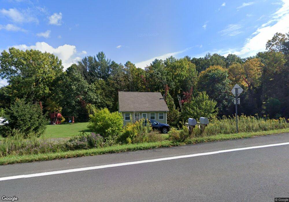
1321 State Route 82 Ancram, NY 12502
Estimated Value: $239,277 - $387,000
2
Beds
1
Bath
1,095
Sq Ft
$285/Sq Ft
Est. Value
About This Home
This home is located at 1321 State Route 82, Ancram, NY 12502 and is currently estimated at $311,819, approximately $284 per square foot. 1321 State Route 82 is a home located in Columbia County with nearby schools including Germantown Elementary School and Germantown Junior/Senior High School.
Ownership History
Date
Name
Owned For
Owner Type
Purchase Details
Closed on
Oct 20, 2014
Sold by
Shanahan Michael
Bought by
Picard Joseph and Picard
Current Estimated Value
Home Financials for this Owner
Home Financials are based on the most recent Mortgage that was taken out on this home.
Original Mortgage
$122,735
Outstanding Balance
$95,020
Interest Rate
4.37%
Mortgage Type
FHA
Estimated Equity
$216,799
Purchase Details
Closed on
Sep 21, 2010
Sold by
Trustco Bank
Bought by
Shanahan Michael
Purchase Details
Closed on
Mar 19, 2003
Sold by
Weaver Barbara A
Bought by
Grossarth Michael
Create a Home Valuation Report for This Property
The Home Valuation Report is an in-depth analysis detailing your home's value as well as a comparison with similar homes in the area
Home Values in the Area
Average Home Value in this Area
Purchase History
| Date | Buyer | Sale Price | Title Company |
|---|---|---|---|
| Picard Joseph | $125,000 | -- | |
| Shanahan Michael | $31,500 | -- | |
| Grossarth Michael | $85,000 | Robert J Gagen |
Source: Public Records
Mortgage History
| Date | Status | Borrower | Loan Amount |
|---|---|---|---|
| Open | Picard Joseph | $122,735 |
Source: Public Records
Tax History Compared to Growth
Tax History
| Year | Tax Paid | Tax Assessment Tax Assessment Total Assessment is a certain percentage of the fair market value that is determined by local assessors to be the total taxable value of land and additions on the property. | Land | Improvement |
|---|---|---|---|---|
| 2024 | $2,605 | $142,000 | $43,000 | $99,000 |
| 2023 | $2,704 | $142,000 | $43,000 | $99,000 |
| 2022 | $2,813 | $142,000 | $43,000 | $99,000 |
| 2021 | $2,804 | $142,000 | $43,000 | $99,000 |
| 2020 | $2,474 | $142,000 | $43,000 | $99,000 |
| 2019 | $196 | $75,000 | $47,000 | $28,000 |
| 2018 | $1,632 | $75,000 | $47,000 | $28,000 |
| 2017 | $1,586 | $75,000 | $47,000 | $28,000 |
| 2016 | $1,611 | $75,000 | $47,000 | $28,000 |
| 2015 | -- | $75,000 | $47,000 | $28,000 |
| 2014 | -- | $75,000 | $47,000 | $28,000 |
Source: Public Records
Map
Nearby Homes
- 46 Brothers Rd
- 59 New Forge Road II Unit 1
- 0 County Route 10 Unit KEY842732
- 455 Post Hill Rd
- 472 Doodletown Rd
- 1899 County Route 10
- 270 Hull Rd Unit Stop 3
- 42 E Pond Lilly Rd
- 490 Old Route 82
- 803 County Route 27
- 220 W Pond Lily Rd
- 490 Old State Route 82
- 630 County Route 11
- 2727 County Route 8
- 4 Greely Rd
- 0 County Route 7 Unit KEYH6308186
- 0 County Route 7 Unit 152778
- 91 Decker Rd
- 160 Willowbrook Rd
- 134 Willowbrook Rd
- 1321 S Rte 82
- 1339 State Route 82
- 1336 New York 82
- 1336 State Route 82 Unit 4B
- 1342 New York 82
- 1342 State Route 82 Unit 4A
- 1300 State Route 82
- 1300 State Route 82 --
- 636 New Forge Road II Unit 2
- 603 New Forge Road II Unit 82
- 1300 New York 82
- 1300 State Rt 82
- 1294 State Route 82
- 658 New Forge Road II
- 637 New Forge Road II
- 637 New Forge Rd II
- 1336 State Rte 82 Unit 4B
- 1360 State Route 82
- 1260 State Route 82
- 1273 State Route 82