1322 Woodside Dr NW Cedar Rapids, IA 52405
Estimated payment $1,883/month
Highlights
- Very Popular Property
- Deck
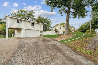
- 2 Car Detached Garage
- John F. Kennedy High School Rated A-
- Walk-In Pantry
- Eat-In Kitchen
About This Home
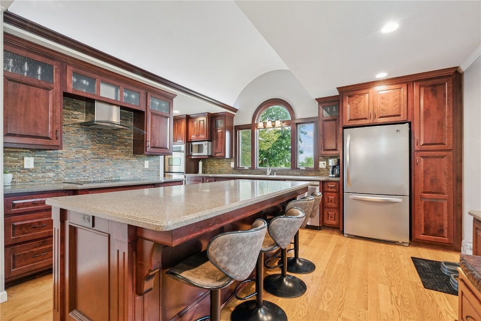
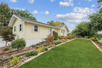
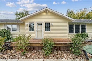
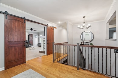
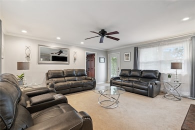
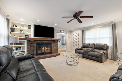
You really need to step inside to get the full effect! The large foyer welcomes you and directs your attention to the updated kitchen that is any chef's delight with beautiful upgraded cabinets, hard surfaced counters, an island, and stainless steel appliances. Just around the corner is your walk-in pantry! With 1660 sf of living space, each room is very spacious. The bathrooms have been updated as well. The .376 ac lot offers privacy with a fenced yard and multiple decks to enjoy your time. Don't forget to check out the second story in the garage! It could make an excellent office, game room, you name it, it could be an amazing extra living space to enjoy! This home also offers a new furnace/air conditioning and a new sewer line! Most seasons, the front hill is full of perennials and looks beautiful like your own nature preserve! Come take a look, you won't be disappointed!

Home Details
Home Type
- Single Family
Est. Annual Taxes
- $4,575
Year Built
- Built in 1924
Lot Details
- 0.38 Acre Lot
- Fenced
Parking
- 2 Car Detached Garage
- Carport
- Garage Door Opener
Home Design
- Poured Concrete
- Frame Construction
- Vinyl Siding
Interior Spaces
- 1-Story Property
- Wood Burning Fireplace
- Living Room with Fireplace
- Basement
Kitchen
- Eat-In Kitchen
- Walk-In Pantry
- Range
- Microwave
- Dishwasher
Bedrooms and Bathrooms
- 3 Bedrooms
- 2 Full Bathrooms
Outdoor Features
- Deck
Schools
- Madison Elementary School
- Roosevelt Middle School
- Kennedy High School
Utilities
- Forced Air Heating and Cooling System
- Heating System Uses Gas
- Electric Water Heater
Listing and Financial Details
- Assessor Parcel Number 14192-51017-00000
Map
Home Values in the Area
Average Home Value in this Area
Tax History
| Year | Tax Paid | Tax Assessment Tax Assessment Total Assessment is a certain percentage of the fair market value that is determined by local assessors to be the total taxable value of land and additions on the property. | Land | Improvement |
|---|---|---|---|---|
| 2025 | $4,090 | $257,000 | $44,200 | $212,800 |
| 2024 | $4,180 | $252,600 | $44,200 | $208,400 |
| 2023 | $4,180 | $231,100 | $37,900 | $193,200 |
| 2022 | $3,972 | $198,200 | $37,900 | $160,300 |
| 2021 | $4,148 | $191,700 | $37,900 | $153,800 |
| 2020 | $4,148 | $188,000 | $33,700 | $154,300 |
| 2019 | $3,842 | $178,200 | $33,700 | $144,500 |
| 2018 | $3,734 | $178,200 | $33,700 | $144,500 |
| 2017 | $3,041 | $152,500 | $33,700 | $118,800 |
| 2016 | $3,041 | $143,100 | $33,700 | $109,400 |
| 2015 | $2,856 | $137,783 | $33,669 | $104,114 |
| 2014 | $2,746 | $137,783 | $33,669 | $104,114 |
| 2013 | $2,684 | $137,783 | $33,669 | $104,114 |
Property History
| Date | Event | Price | List to Sale | Price per Sq Ft |
|---|---|---|---|---|
| 11/07/2025 11/07/25 | Price Changed | $285,000 | -3.4% | $138 / Sq Ft |
| 10/19/2025 10/19/25 | Price Changed | $294,999 | -1.3% | $143 / Sq Ft |
| 10/07/2025 10/07/25 | For Sale | $299,000 | -- | $145 / Sq Ft |
Purchase History
| Date | Type | Sale Price | Title Company |
|---|---|---|---|
| Warranty Deed | -- | None Available | |
| Warranty Deed | $119,500 | None Available |
Mortgage History
| Date | Status | Loan Amount | Loan Type |
|---|---|---|---|
| Open | $36,200 | Unknown | |
| Previous Owner | $120,000 | Unknown |
Source: Cedar Rapids Area Association of REALTORS®
MLS Number: 2508433
APN: 14192-51017-00000
Disclaimer: Certain information contained herein is derived from information provided by parties other than Homes.com. All information provided is deemed reliable, but is not guaranteed to be accurate and should be independently verified.
![]() IDX information is provided exclusively for personal, non-commercial use, and may not be used for any purpose other than to identify prospective properties consumers may be interested in purchasing.
IDX information is provided exclusively for personal, non-commercial use, and may not be used for any purpose other than to identify prospective properties consumers may be interested in purchasing.
Information is deemed reliable but not guaranteed.
- 2801 Schultz Dr NW
- 3313 Crestwood Dr NW
- 912 29th St NW
- 1613 Southview Dr NW
- 2623 Iris Ave NW
- 327* Edgewood Rd NW
- 2520 N Ave NW
- 3312 G Ave NW
- 1733 Hillside Dr NW
- 949 Westwood Dr NW
- 623 27th St NW
- 615 27th St NW
- 2210 O Ave NW
- 1410 Adair Ct SW Unit Lot 2
- 425 28th St NW
- 3509 E Ave NW Unit D
- 451 23rd St NW
- 327 NW Edgewood Rd Unit 324, 330, 336, 342 C
- 0 O Ave NW
- 1814 Shawnee Ct NW
- 1270 Edgewood Rd NW
- 1601 30th St NW
- 321 28th St NW
- 2202-2238 River Bluffs Dr
- 2415 River Bluff Dr NW
- 1210 Auburn Dr SW
- 2200 Buckingham Dr NW
- 4419 1st Ave SW
- 605 G Ave NW
- 110 Jacolyn Dr SW
- 702 9th St SW Unit 1
- 702 9th St SW Unit 2
- 5150 16th Ave SW
- 5200 16th Ave SW
- 4227 21st Ave SW
- 2155 Westdale Dr SW
- 901 9th St SW Unit Upper
- 1310-1320 Wenig Rd NE
- 100 1st Ave NE
- 200 1st Ave NE