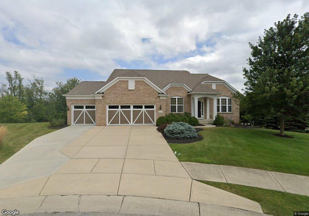
13231 Fenwick St Fishers, IN 46037
Estimated Value: $493,000 - $685,000
3
Beds
3
Baths
4,347
Sq Ft
$140/Sq Ft
Est. Value
About This Home
This home is located at 13231 Fenwick St, Fishers, IN 46037 and is currently estimated at $607,112, approximately $139 per square foot. 13231 Fenwick St is a home located in Hamilton County with nearby schools including Overland Park Elementary School, Thorpe Creek Elementary School, and Hamilton Southeastern Intermediate / Junior High.
Ownership History
Date
Name
Owned For
Owner Type
Purchase Details
Closed on
Jun 29, 2011
Sold by
Pulte Homes Of Indiana Llc
Bought by
Terrell Robert M and Terrell Suzanne L
Current Estimated Value
Home Financials for this Owner
Home Financials are based on the most recent Mortgage that was taken out on this home.
Original Mortgage
$50,000
Outstanding Balance
$3,778
Interest Rate
4.63%
Mortgage Type
New Conventional
Estimated Equity
$603,334
Create a Home Valuation Report for This Property
The Home Valuation Report is an in-depth analysis detailing your home's value as well as a comparison with similar homes in the area
Home Values in the Area
Average Home Value in this Area
Purchase History
| Date | Buyer | Sale Price | Title Company |
|---|---|---|---|
| Terrell Robert M | -- | None Available |
Source: Public Records
Mortgage History
| Date | Status | Borrower | Loan Amount |
|---|---|---|---|
| Open | Terrell Robert M | $50,000 |
Source: Public Records
Tax History Compared to Growth
Tax History
| Year | Tax Paid | Tax Assessment Tax Assessment Total Assessment is a certain percentage of the fair market value that is determined by local assessors to be the total taxable value of land and additions on the property. | Land | Improvement |
|---|---|---|---|---|
| 2024 | $6,429 | $582,800 | $86,200 | $496,600 |
| 2023 | $6,429 | $554,500 | $86,200 | $468,300 |
| 2022 | $5,920 | $491,300 | $86,200 | $405,100 |
| 2021 | $5,382 | $445,800 | $86,200 | $359,600 |
| 2020 | $5,166 | $423,800 | $86,200 | $337,600 |
| 2019 | $5,069 | $415,900 | $57,100 | $358,800 |
| 2018 | $4,764 | $390,200 | $57,100 | $333,100 |
| 2017 | $4,564 | $380,400 | $64,200 | $316,200 |
| 2016 | $4,703 | $392,900 | $64,200 | $328,700 |
| 2014 | $3,828 | $352,300 | $64,200 | $288,100 |
| 2013 | $3,828 | $346,400 | $64,200 | $282,200 |
Source: Public Records
Map
Nearby Homes
- 13935 Canonbury Way
- 14237 Bay Willow Dr
- 12878 Ari Ln
- 14110 Bay Willow Dr
- 12880 Oxbridge Place
- 13008 Overview Dr
- 13616 Whitten Dr N
- 12985 Saxony Blvd
- 12748 Tamworth Dr
- 13172 Saxony Blvd
- 13896 Willesden Cir
- 12706 Hannah Hill Rd
- 13330 Saxony Blvd W
- 12680 Tamworth Dr
- 14156 Avalon Dr E
- 13484 Molique Blvd
- 13423 E 134th St
- 13301 Minden Dr
- 14584 Hinton Dr
- 13311 Susser Way
- 13241 Fenwick St
- 13207 Fenwick St
- 14090 Bagham Dr
- 13240 Fenwick St
- 13216 Fenwick St
- 13228 Fenwick St
- 14101 Bagham Dr
- 13195 Fenwick St
- 13204 Fenwick St
- 14102 Bagham Dr
- 14113 Bagham Dr
- 13192 Fenwick St
- 13183 Fenwick St
- 14114 Bagham Dr
- 13180 Fenwick St
- 14125 Bagham Dr
- 13121 Pinner Ave
- 13115 Pinner Ave
- 13145 Cresswell Place
- 13171 Fenwick St