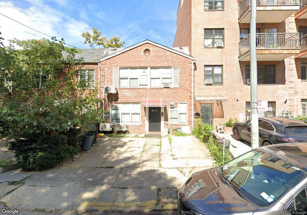
13235 Avery Ave Flushing, NY 11355
Flushing-Willets Point NeighborhoodEstimated Value: $1,347,076 - $1,974,000
Studio
--
Bath
2,000
Sq Ft
$765/Sq Ft
Est. Value
About This Home
This home is located at 13235 Avery Ave, Flushing, NY 11355 and is currently estimated at $1,529,019, approximately $764 per square foot. 13235 Avery Ave is a home located in Queens County with nearby schools including P.S. 120 - Queens, Rachel Carson I.S. 237Q, and John Bowne High School.
Ownership History
Date
Name
Owned For
Owner Type
Purchase Details
Closed on
Nov 5, 2020
Sold by
Ding Guo Sheng and Hu Ruo Dan
Bought by
Lin Xing
Current Estimated Value
Purchase Details
Closed on
Aug 27, 2007
Sold by
Ding Guo Sheng
Bought by
Ding Guo Sheng and Hu Ruo Dan
Purchase Details
Closed on
Dec 14, 2005
Sold by
Ding Guo Sheng and Ding Xian Chun
Bought by
Ding Guo Sheng
Purchase Details
Closed on
Oct 31, 1997
Sold by
Frontier Development Usa Inc
Bought by
Ding Xian Chun and Ding Guo Sheng
Home Financials for this Owner
Home Financials are based on the most recent Mortgage that was taken out on this home.
Original Mortgage
$150,000
Interest Rate
7.26%
Create a Home Valuation Report for This Property
The Home Valuation Report is an in-depth analysis detailing your home's value as well as a comparison with similar homes in the area
Home Values in the Area
Average Home Value in this Area
Purchase History
| Date | Buyer | Sale Price | Title Company |
|---|---|---|---|
| Lin Xing | $1,068,000 | -- | |
| Lin Xing | $1,068,000 | -- | |
| Ding Guo Sheng | -- | -- | |
| Ding Guo Sheng | -- | -- | |
| Ding Guo Sheng | -- | -- | |
| Ding Guo Sheng | -- | -- | |
| Ding Xian Chun | $225,000 | -- | |
| Ding Xian Chun | $225,000 | -- |
Source: Public Records
Mortgage History
| Date | Status | Borrower | Loan Amount |
|---|---|---|---|
| Previous Owner | Ding Xian Chun | $150,000 |
Source: Public Records
Tax History
| Year | Tax Paid | Tax Assessment Tax Assessment Total Assessment is a certain percentage of the fair market value that is determined by local assessors to be the total taxable value of land and additions on the property. | Land | Improvement |
|---|---|---|---|---|
| 2025 | $8,808 | $44,191 | $8,916 | $35,275 |
| 2024 | $8,808 | $43,855 | $10,602 | $33,253 |
| 2023 | $8,403 | $41,374 | $10,999 | $30,375 |
| 2022 | $7,793 | $75,300 | $20,640 | $54,660 |
| 2021 | $7,750 | $80,520 | $20,640 | $59,880 |
| 2020 | $7,795 | $69,240 | $20,640 | $48,600 |
| 2019 | $7,645 | $59,280 | $20,640 | $38,640 |
| 2018 | $7,028 | $34,478 | $10,269 | $24,209 |
| 2017 | $6,631 | $32,529 | $8,867 | $23,662 |
| 2016 | $6,135 | $32,529 | $8,867 | $23,662 |
| 2015 | $3,482 | $30,688 | $11,038 | $19,650 |
| 2014 | $3,482 | $30,455 | $11,739 | $18,716 |
Source: Public Records
Map
Nearby Homes
- 132-51 Avery Ave
- 132-47 Pople Ave
- 13239 Pople Ave Unit 2A
- 132-36 Pople Ave Unit BA
- 132-36 Pople Ave Unit 3
- 133-32 Avery Ave
- 132-25 Avery Ave
- 132-16 Maple Ave Unit 5A
- 13216 Maple Ave Unit 3A
- 134-11 Franklin Ave Unit 3F
- 134-11 Franklin Ave Unit 6E
- 134-11 Franklin Ave Unit 7C
- 134-11 Franklin Ave Unit 6F
- 134-11 Franklin Ave Unit 6B
- 134-11 Franklin Ave Unit 7A
- 134-11 Franklin Ave Unit 4A
- 134-11 Franklin Ave Unit 4F
- 134-11 Franklin Ave Unit 7D
- 134-11 Franklin Ave Unit 3A
- 134-11 Franklin Ave Unit 9A
- 132-35 Avery Ave
- 13237 Avery Ave
- 13231 Avery Ave
- 13233 Avery Ave
- 13239 Avery Ave
- 13229 Avery Ave
- 13241 Avery Ave
- 13227 Avery Ave
- 13245 Avery Ave
- 132-45 Avery Ave
- 13228 Pople Ave
- 132-30 Pople Ave Unit 6
- 132-30 Pople Ave Unit 3
- 13225 Avery Ave
- 13226 Pople Ave
- 13236 Pople Ave Unit 5B
- 13236 Pople Ave Unit 4B
- 13236 Pople Ave Unit PC4
- 13236 Pople Ave Unit P11
- 13236 Pople Ave Unit P5
Your Personal Tour Guide
Ask me questions while you tour the home.