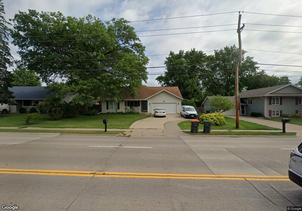
1324 W 53rd St Davenport, IA 52806
North Side NeighborhoodEstimated Value: $253,168 - $277,000
2
Beds
2
Baths
1,318
Sq Ft
$199/Sq Ft
Est. Value
About This Home
This home is located at 1324 W 53rd St, Davenport, IA 52806 and is currently estimated at $262,042, approximately $198 per square foot. 1324 W 53rd St is a home located in Scott County with nearby schools including Cumberland Hall School, Harrison Elementary School, and Academy Of Continuing Education.
Ownership History
Date
Name
Owned For
Owner Type
Purchase Details
Closed on
Sep 27, 2019
Sold by
Sheridan Jerome and Sheridan Joan
Bought by
Yates Richard and Yates Georgina
Current Estimated Value
Purchase Details
Closed on
Oct 15, 2010
Sold by
Peters Douglas H and Bibbs Anthony L
Bought by
Sheridan Jerome and Sheridan Joan
Purchase Details
Closed on
Apr 9, 2009
Sold by
Giles Evelyn J
Bought by
Giles Evelyn J and Evelyn J Giles Revocable Trust
Create a Home Valuation Report for This Property
The Home Valuation Report is an in-depth analysis detailing your home's value as well as a comparison with similar homes in the area
Home Values in the Area
Average Home Value in this Area
Purchase History
| Date | Buyer | Sale Price | Title Company |
|---|---|---|---|
| Yates Richard | $180,000 | -- | |
| Sheridan Jerome | $147,000 | None Available | |
| Giles Evelyn J | -- | None Available |
Source: Public Records
Tax History Compared to Growth
Tax History
| Year | Tax Paid | Tax Assessment Tax Assessment Total Assessment is a certain percentage of the fair market value that is determined by local assessors to be the total taxable value of land and additions on the property. | Land | Improvement |
|---|---|---|---|---|
| 2025 | $3,348 | $220,580 | $36,760 | $183,820 |
| 2024 | $3,380 | $211,270 | $36,760 | $174,510 |
| 2023 | $3,594 | $211,270 | $36,760 | $174,510 |
| 2022 | $3,608 | $177,110 | $28,410 | $148,700 |
| 2021 | $3,608 | $177,110 | $28,410 | $148,700 |
| 2020 | $3,328 | $172,640 | $28,410 | $144,230 |
| 2019 | $3,290 | $155,140 | $28,410 | $126,730 |
| 2018 | $3,216 | $155,140 | $28,410 | $126,730 |
| 2017 | $3,114 | $155,140 | $28,410 | $126,730 |
| 2016 | $2,996 | $145,500 | $0 | $0 |
| 2015 | $2,996 | $142,920 | $0 | $0 |
| 2014 | $2,980 | $142,920 | $0 | $0 |
| 2013 | $2,924 | $0 | $0 | $0 |
| 2012 | -- | $140,550 | $26,900 | $113,650 |
Source: Public Records
Map
Nearby Homes
- 5721 Taylor St
- 5735 Taylor St
- 4757 Willow Cir
- 4743 Willow Cir
- 5804 Lillie Ave
- 1033 W 58th St
- 1415 W 59th St
- 4804 Northwest Blvd
- 1005 W 58th St
- 5436 N Division St
- 4942 Brown St
- 825 Northbrook Dr
- 5210 N Division St
- 5510 N Division St
- 4705 N Sturdevant St
- 1729 Welshire Dr
- 4618 Fillmore Ln
- 4612 Warren St Unit 5
- 6015 Vine St
- 710 Northbrook Dr
- 1332 W 53rd St
- 1325 W 54th St
- 1331 W 54th St
- 5306 N Marquette St
- 1317 W 54th St
- 1338 W 53rd St
- 5306 Marquette St
- 1315 W 53rd St
- 1335 W 54th St
- 5316 Marquette St
- 1350 W 53rd St
- 1305 W 53rd St
- 1341 W 54th St
- 1320 W 54th St
- 0 W 54th Unit 17-21 7031408
- 1308 W 54th St
- 1407 W 54th St
- 5311 Marquette St
- 5411 Taylor St
- 1327 W 53rd St