Estimated Value: $55,000 - $123,000
2
Beds
1
Bath
800
Sq Ft
$97/Sq Ft
Est. Value
About This Home
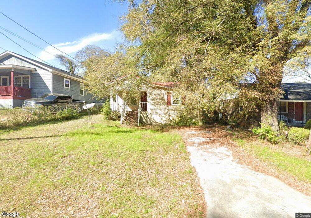
This home is located at 1327 Van St, Perry, GA 31069 and is currently estimated at $77,299, approximately $96 per square foot. 1327 Van St is a home located in Houston County with nearby schools including Morningside Elementary School, Perry Middle School, and Perry High School.
Ownership History
Date
Name
Owned For
Owner Type
Purchase Details
Closed on
Feb 3, 2019
Sold by
Brown Edward
Bought by
Eubanks Beatrice
Current Estimated Value
Purchase Details
Closed on
Jun 17, 1998
Sold by
Brown Lee Daniel
Bought by
Eubanks Beatrice
Purchase Details
Closed on
Jun 4, 1998
Sold by
Brown Nathan
Bought by
Eubanks Beatrice
Purchase Details
Closed on
Jun 3, 1998
Sold by
Brown Joseph
Bought by
Eubanks Beatrice
Purchase Details
Closed on
Jun 1, 1998
Sold by
Brown Nathan Se Estate
Bought by
Eubanks Beatrice Etal
Purchase Details
Closed on
May 13, 1974
Sold by
Eubanks Anthony and Eubanks Beatrice B
Bought by
Brown Nathan and Brown Blanche
Purchase Details
Closed on
Aug 4, 1970
Sold by
M M & B Inc
Bought by
Brown Nathan Etal
Purchase Details
Closed on
Oct 15, 1955
Bought by
Brown Nathan
Create a Home Valuation Report for This Property
The Home Valuation Report is an in-depth analysis detailing your home's value as well as a comparison with similar homes in the area
Home Values in the Area
Average Home Value in this Area
Purchase History
| Date | Buyer | Sale Price | Title Company |
|---|---|---|---|
| Eubanks Beatrice | -- | None Available | |
| Eubanks Beatrice | -- | -- | |
| Eubanks Beatrice | -- | -- | |
| Eubanks Beatrice | -- | -- | |
| Eubanks Beatrice Etal | -- | -- | |
| Brown Nathan | -- | -- | |
| Brown Nathan Etal | -- | -- | |
| M M & B Inc | $2,000 | -- | |
| Brown Nathan | $300 | -- |
Source: Public Records
Tax History
| Year | Tax Paid | Tax Assessment Tax Assessment Total Assessment is a certain percentage of the fair market value that is determined by local assessors to be the total taxable value of land and additions on the property. | Land | Improvement |
|---|---|---|---|---|
| 2024 | $325 | $8,840 | $1,360 | $7,480 |
| 2023 | $278 | $7,520 | $1,360 | $6,160 |
| 2022 | $162 | $7,040 | $1,360 | $5,680 |
| 2021 | $153 | $6,600 | $1,360 | $5,240 |
| 2020 | $153 | $6,600 | $1,360 | $5,240 |
| 2019 | $153 | $6,600 | $1,360 | $5,240 |
| 2018 | $153 | $6,600 | $1,360 | $5,240 |
| 2017 | $153 | $6,600 | $1,360 | $5,240 |
| 2016 | $154 | $6,600 | $1,360 | $5,240 |
| 2015 | $154 | $6,600 | $1,360 | $5,240 |
| 2014 | -- | $6,600 | $1,360 | $5,240 |
| 2013 | -- | $6,600 | $1,360 | $5,240 |
Source: Public Records
Map
Nearby Homes
- 1343 Wf Ragin Dr
- 1335 Ball St
- 104 Pridgen Pass
- 118 Pridgen Pass
- 119 Pridgen Pass
- 1312 Sam Nunn Blvd
- 106 Cassandra Ann Way
- 200 Farrell Way
- 202 Farrell Way
- The Pearson Plan at Avalon
- The Crawford Plan at Avalon
- The Piedmont Plan at Avalon
- The McGinnis Plan at Avalon
- The Coleman Plan at Avalon
- The Lawson Plan at Avalon
- The Bradley Plan at Avalon
- The Harrington Plan at Avalon
- 0 Perimeter Rd Unit 236479
- 0 Perimeter Rd Unit 20145467
- 0 Perimeter Rd Unit 236478
Your Personal Tour Guide
Ask me questions while you tour the home.