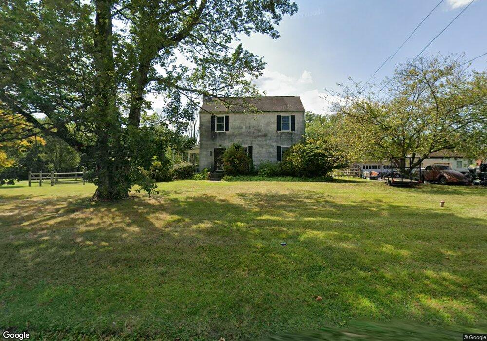
1328 Cowpath Rd Hatfield, PA 19440
Estimated Value: $347,414 - $442,000
3
Beds
1
Bath
1,302
Sq Ft
$300/Sq Ft
Est. Value
About This Home
This home is located at 1328 Cowpath Rd, Hatfield, PA 19440 and is currently estimated at $390,854, approximately $300 per square foot. 1328 Cowpath Rd is a home located in Montgomery County with nearby schools including Oak Park El School, Pennfield Middle School, and North Penn Senior High School.
Ownership History
Date
Name
Owned For
Owner Type
Purchase Details
Closed on
Jun 20, 2003
Sold by
Conner Eric W and Conner Kristi L
Bought by
Doering Michael W
Current Estimated Value
Purchase Details
Closed on
Sep 27, 1996
Sold by
Kavka Frank J and Kavka Hope B
Bought by
Conner Eric W and Conner Kristi L
Purchase Details
Closed on
Dec 31, 1993
Sold by
Peszko Anna V
Bought by
Kavka Frank J and Kavka Hope B
Create a Home Valuation Report for This Property
The Home Valuation Report is an in-depth analysis detailing your home's value as well as a comparison with similar homes in the area
Home Values in the Area
Average Home Value in this Area
Purchase History
| Date | Buyer | Sale Price | Title Company |
|---|---|---|---|
| Doering Michael W | $184,000 | -- | |
| Conner Eric W | $127,000 | -- | |
| Kavka Frank J | $118,000 | -- |
Source: Public Records
Tax History
| Year | Tax Paid | Tax Assessment Tax Assessment Total Assessment is a certain percentage of the fair market value that is determined by local assessors to be the total taxable value of land and additions on the property. | Land | Improvement |
|---|---|---|---|---|
| 2025 | $4,042 | $100,980 | $49,530 | $51,450 |
| 2024 | $4,042 | $100,980 | $49,530 | $51,450 |
| 2023 | $3,869 | $100,980 | $49,530 | $51,450 |
| 2022 | $3,743 | $100,980 | $49,530 | $51,450 |
| 2021 | $3,637 | $100,980 | $49,530 | $51,450 |
| 2020 | $3,551 | $100,980 | $49,530 | $51,450 |
| 2019 | $3,492 | $100,980 | $49,530 | $51,450 |
Source: Public Records
Map
Nearby Homes
- 1309 W Orvilla Rd
- 1524 Tarrington Way
- 1315 Deer Run Rd
- 113 E Vine St
- 2092 Hawthorne Ln
- 2296 Bramble Gate Dr
- 369 Wheatfield Cir
- 105 S Main St
- 109 Hickory Dr
- 113 Hickory Dr
- 122 Wyndham Woods Way
- 0 Fairmount St
- 36 N Maple Ave
- 9 Fortuna Dr
- 8 Fortuna Dr
- 5 Fortuna Dr
- 6 Fortuna Dr
- 138 Diamond St Unit 31
- 2248 W Walnut St Unit 6
- 2801 Denbeigh Dr
- 1340 Cowpath Rd
- 1320 Cowpath Rd
- 1306 Cowpath Rd
- 1345 Cowpath Rd
- 1421 Cowpath Rd Unit 26
- 1240 Cowpath Rd
- 1440 Cowpath Rd Unit 15
- 1931 E Orvilla Rd Unit 23
- 1307 Cowpath Rd
- 1441 W Orvilla Rd
- 1441 W Orvilla Rd Unit 2ND FLR
- 1435 W Orvilla Rd
- 1941 E Orvilla Rd
- 1916 E Orvilla Rd
- 1230 Cowpath Rd
- 1505 Cowpath Rd
- 1301 Cowpath Rd
- 1926 E Orvilla Rd
- 1421 W Orvilla Rd
- 1208 Cowpath Rd
Your Personal Tour Guide
Ask me questions while you tour the home.