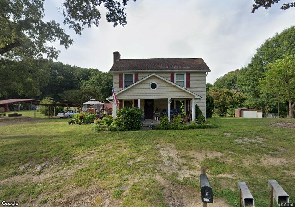
1329 Confederate Rd Lincolnton, NC 28092
Estimated Value: $230,000 - $334,985
3
Beds
2
Baths
1,482
Sq Ft
$190/Sq Ft
Est. Value
About This Home
This home is located at 1329 Confederate Rd, Lincolnton, NC 28092 and is currently estimated at $282,246, approximately $190 per square foot. 1329 Confederate Rd is a home located in Lincoln County with nearby schools including Love Memorial Elementary School, West Lincoln Middle, and West Lincoln High School.
Ownership History
Date
Name
Owned For
Owner Type
Purchase Details
Closed on
Feb 21, 2024
Sold by
Navey David Wayne and Navey Anita S
Bought by
Navey Anita S and Navey Jesse Wayne
Current Estimated Value
Purchase Details
Closed on
Mar 6, 2020
Sold by
Navey David Wayne and Navey Anita S
Bought by
Navey David Wayne and Navey Anita S
Purchase Details
Closed on
Oct 7, 2019
Sold by
Navey John William and Navey Taylor E
Bought by
Navey David Wayne and Navey Anita S
Purchase Details
Closed on
Oct 6, 2017
Sold by
Navey David Wayne and Navey Anita S
Bought by
Navey Jesse Wayne and Navey John William
Create a Home Valuation Report for This Property
The Home Valuation Report is an in-depth analysis detailing your home's value as well as a comparison with similar homes in the area
Home Values in the Area
Average Home Value in this Area
Purchase History
| Date | Buyer | Sale Price | Title Company |
|---|---|---|---|
| Navey Anita S | -- | None Listed On Document | |
| Navey David Wayne | -- | None Available | |
| Navey David Wayne | -- | None Available | |
| Navey Jesse Wayne | -- | None Available |
Source: Public Records
Tax History Compared to Growth
Tax History
| Year | Tax Paid | Tax Assessment Tax Assessment Total Assessment is a certain percentage of the fair market value that is determined by local assessors to be the total taxable value of land and additions on the property. | Land | Improvement |
|---|---|---|---|---|
| 2025 | $1,461 | $250,273 | $69,188 | $181,085 |
| 2024 | $1,441 | $250,273 | $69,188 | $181,085 |
| 2023 | $1,436 | $250,273 | $69,188 | $181,085 |
| 2022 | $1,067 | $162,883 | $61,434 | $101,449 |
| 2021 | $1,067 | $162,883 | $61,434 | $101,449 |
| 2020 | $926 | $162,883 | $61,434 | $101,449 |
| 2019 | $926 | $162,883 | $61,434 | $101,449 |
| 2018 | $866 | $139,107 | $59,434 | $79,673 |
| 2017 | $765 | $139,107 | $59,434 | $79,673 |
| 2016 | $765 | $139,107 | $59,434 | $79,673 |
| 2015 | $836 | $139,107 | $59,434 | $79,673 |
| 2014 | $899 | $155,631 | $62,357 | $93,274 |
Source: Public Records
Map
Nearby Homes
- TBD Southfork Rd
- 1547 Roseland Dr
- 1218 W Highview Ln
- 1672 Riverview Rd
- 000 Riverview Rd
- 1690 Roseland Dr
- 1431 Boy Scout Rd
- 584 Southside Church Rd
- 776 S Grove St Unit EXT
- 1156 Lyn Well Rd
- 792 Carolina Mill Cir
- 00 Lake Sylvia Rd
- 00 Glenn St
- 2130 Drive Inn Rd
- 3347 & 3349 Gastonia Hwy
- 0 Drive Inn Rd
- 000 Southside Rd
- 110 Robin Rd
- 140 Robin Rd
- 818 Grier St
- 1340 Confederate Rd
- 1349 Confederate Rd
- 1352 Confederate Rd
- 1299 Confederate Rd
- 1380 Confederate Rd
- 1276 Confederate Rd
- 1394 Confederate Rd
- 1241 Confederate Rd
- 1411 Confederate Rd
- 1250 Confederate Rd
- 1427 Confederate Rd
- 1236 Confederate Rd
- 1211 Village Rd
- 1217 Village Rd Unit 1
- 1217 Village Rd
- 2632 Laboratory Rd
- 1207 Confederate Rd
- 2645 Laboratory Rd
- 1204 Village Rd
- 1186 Confederate Rd