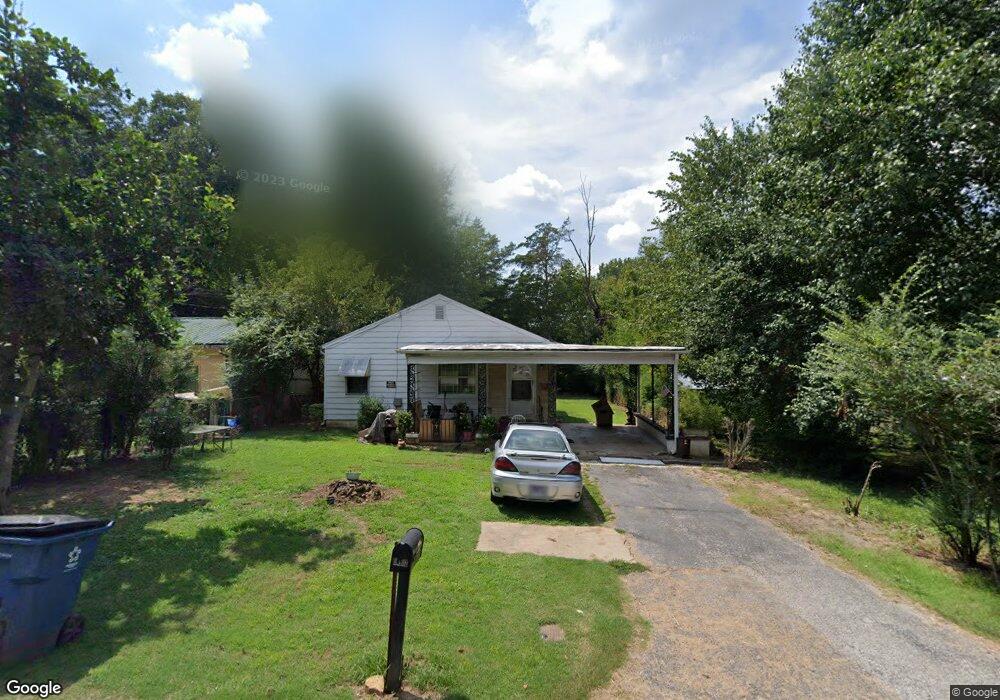
1329 Sunset St Humboldt, TN 38343
Estimated Value: $72,000 - $81,000
3
Beds
1
Bath
940
Sq Ft
$81/Sq Ft
Est. Value
About This Home
This home is located at 1329 Sunset St, Humboldt, TN 38343 and is currently estimated at $76,295, approximately $81 per square foot. 1329 Sunset St is a home located in Gibson County with nearby schools including Stigall Primary School, East Elementary School, and Humboldt Middle School.
Ownership History
Date
Name
Owned For
Owner Type
Purchase Details
Closed on
Jun 20, 2018
Sold by
Lit Benjamin N
Bought by
Hensley Richard and Hensley Patricia
Current Estimated Value
Purchase Details
Closed on
Jun 17, 2011
Sold by
Wilson Nancy
Bought by
Lit Benjamin N and Lit Carrie
Home Financials for this Owner
Home Financials are based on the most recent Mortgage that was taken out on this home.
Original Mortgage
$21,600
Interest Rate
4.63%
Mortgage Type
Commercial
Purchase Details
Closed on
Jul 26, 2005
Sold by
Cooley Bruce L
Bought by
Guthrie Jane
Purchase Details
Closed on
Jan 2, 1974
Bought by
Cooley Bruce L and Cooley Margie
Purchase Details
Closed on
Oct 30, 1951
Create a Home Valuation Report for This Property
The Home Valuation Report is an in-depth analysis detailing your home's value as well as a comparison with similar homes in the area
Home Values in the Area
Average Home Value in this Area
Purchase History
| Date | Buyer | Sale Price | Title Company |
|---|---|---|---|
| Hensley Richard | $22,000 | -- | |
| Lit Benjamin N | $27,000 | -- | |
| Guthrie Jane | $44,000 | -- | |
| Cooley Bruce L | -- | -- | |
| -- | -- | -- |
Source: Public Records
Mortgage History
| Date | Status | Borrower | Loan Amount |
|---|---|---|---|
| Previous Owner | Lit Benjamin N | $21,600 |
Source: Public Records
Tax History Compared to Growth
Tax History
| Year | Tax Paid | Tax Assessment Tax Assessment Total Assessment is a certain percentage of the fair market value that is determined by local assessors to be the total taxable value of land and additions on the property. | Land | Improvement |
|---|---|---|---|---|
| 2025 | $335 | $12,350 | $0 | $0 |
| 2024 | $335 | $12,350 | $2,500 | $9,850 |
| 2023 | $75 | $6,800 | $1,250 | $5,550 |
| 2022 | $70 | $6,800 | $1,250 | $5,550 |
| 2021 | $70 | $6,800 | $1,250 | $5,550 |
| 2020 | $256 | $6,800 | $1,250 | $5,550 |
| 2019 | $256 | $6,800 | $1,250 | $5,550 |
| 2018 | $307 | $7,575 | $1,250 | $6,325 |
| 2017 | $303 | $7,575 | $1,250 | $6,325 |
| 2016 | $303 | $7,575 | $1,250 | $6,325 |
| 2015 | $301 | $7,575 | $1,250 | $6,325 |
| 2014 | $301 | $7,575 | $1,250 | $6,325 |
Source: Public Records
Map
Nearby Homes
- 1338 Dungan St
- 1211 N 29th Ave
- 2508 Vine St
- 811 N 24th Ave
- 2425 St Mary Dr
- 3117 Laurel St
- 2107 Campbell St
- 00000 Lot 7 Mullins St
- 0000 lot 6-C Mullins St
- 000Lot 6-B Mullins St
- 00-lot 6-A Mullins St
- 700 N 29th Ave
- 0 +-6 Acres Gadsden Todd Levee Unit 241321
- 0 Eastend Dr
- 2900 E Mitchell St
- 1012 Parkway Cove
- 171 N 28th Ave
- 1320 Eastview Dr
- 2162 Dodson St
- 1438 N 19th Ave