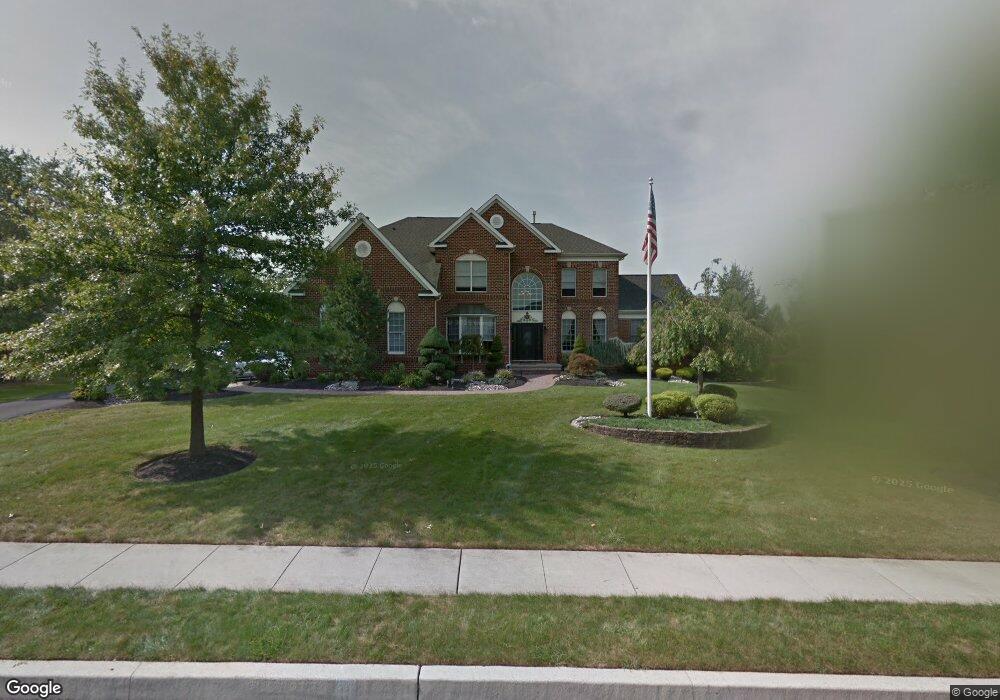
133 Addis Dr Southampton, PA 18966
Estimated Value: $1,199,000 - $1,392,000
4
Beds
4
Baths
3,964
Sq Ft
$323/Sq Ft
Est. Value
About This Home
This home is located at 133 Addis Dr, Southampton, PA 18966 and is currently estimated at $1,278,432, approximately $322 per square foot. 133 Addis Dr is a home located in Bucks County with nearby schools including Maureen M. Welch Elementary School, Richboro Middle School, and Council Rock High School - South.
Ownership History
Date
Name
Owned For
Owner Type
Purchase Details
Closed on
Aug 10, 2011
Sold by
Gallina Thomas P and Gallina Laura J
Bought by
Vacca Michael and Vacca Linda
Current Estimated Value
Home Financials for this Owner
Home Financials are based on the most recent Mortgage that was taken out on this home.
Original Mortgage
$330,000
Outstanding Balance
$25,795
Interest Rate
3.68%
Mortgage Type
New Conventional
Estimated Equity
$1,252,637
Purchase Details
Closed on
Jul 25, 2001
Sold by
Toll Pa Lp
Bought by
Gallina Thomas P and Gallina Laura J
Home Financials for this Owner
Home Financials are based on the most recent Mortgage that was taken out on this home.
Original Mortgage
$398,500
Interest Rate
7.06%
Create a Home Valuation Report for This Property
The Home Valuation Report is an in-depth analysis detailing your home's value as well as a comparison with similar homes in the area
Home Values in the Area
Average Home Value in this Area
Purchase History
| Date | Buyer | Sale Price | Title Company |
|---|---|---|---|
| Vacca Michael | $725,000 | None Available | |
| Gallina Thomas P | $498,125 | -- |
Source: Public Records
Mortgage History
| Date | Status | Borrower | Loan Amount |
|---|---|---|---|
| Open | Vacca Michael | $330,000 | |
| Previous Owner | Gallina Thomas P | $398,500 |
Source: Public Records
Tax History Compared to Growth
Tax History
| Year | Tax Paid | Tax Assessment Tax Assessment Total Assessment is a certain percentage of the fair market value that is determined by local assessors to be the total taxable value of land and additions on the property. | Land | Improvement |
|---|---|---|---|---|
| 2025 | $14,232 | $73,890 | $8,800 | $65,090 |
| 2024 | $14,232 | $73,890 | $8,800 | $65,090 |
| 2023 | $13,413 | $73,890 | $8,800 | $65,090 |
| 2022 | $13,290 | $73,890 | $8,800 | $65,090 |
| 2021 | $12,870 | $73,890 | $8,800 | $65,090 |
| 2020 | $12,581 | $73,890 | $8,800 | $65,090 |
| 2019 | $12,042 | $73,890 | $8,800 | $65,090 |
| 2018 | $11,828 | $73,890 | $8,800 | $65,090 |
| 2017 | $11,371 | $73,890 | $8,800 | $65,090 |
| 2016 | $11,371 | $73,890 | $8,800 | $65,090 |
| 2015 | -- | $73,890 | $8,800 | $65,090 |
| 2014 | -- | $73,890 | $8,800 | $65,090 |
Source: Public Records
Map
Nearby Homes
- 105 Edwards Dr
- 56 Joshua Dr
- 23 Oxford Dr
- 3 Shady Pines Dr
- 34 Acorn Dr
- 55 Mount Pleasant Dr
- 8 Shady Pines Dr
- 61 Legacy Oaks Dr Unit 62
- 290 Hatboro Rd
- 64 Legacy Oaks Dr Unit 81
- 54 Legacy Oaks Dr Unit 94
- 223 Cecelia Acres Dr
- 371 N 2nd Street Pike
- 55 W Windrose Dr
- 636 Almshouse Rd
- 47 Creek Rd
- 29 Devon Rd
- 249 New Rd
- 50 Mohawk Dr
- 534 Holly Knoll Dr