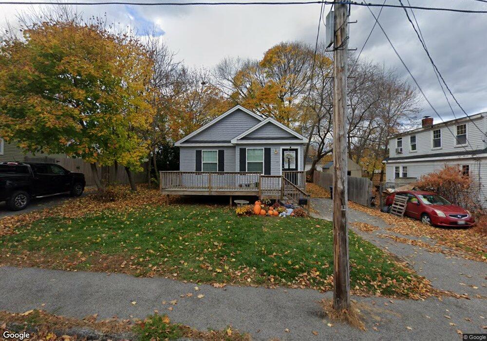
133 Central St Westbrook, ME 04092
Estimated Value: $365,000 - $426,538
2
Beds
2
Baths
912
Sq Ft
$447/Sq Ft
Est. Value
About This Home
This home is located at 133 Central St, Westbrook, ME 04092 and is currently estimated at $407,385, approximately $446 per square foot. 133 Central St is a home located in Cumberland County with nearby schools including Westbrook High School, The Little Dolphin School Foundation, and Breakwater School.
Ownership History
Date
Name
Owned For
Owner Type
Purchase Details
Closed on
Dec 15, 2023
Sold by
Carey Wallace J and Carey Kimberly C
Bought by
Mccue-Mccarthy Alyssa
Current Estimated Value
Home Financials for this Owner
Home Financials are based on the most recent Mortgage that was taken out on this home.
Original Mortgage
$383,918
Outstanding Balance
$377,856
Interest Rate
7.76%
Mortgage Type
FHA
Estimated Equity
$29,529
Purchase Details
Closed on
Nov 12, 2015
Sold by
Carey Belva
Bought by
Carey Kimberly and Carey Wallace J
Purchase Details
Closed on
Oct 13, 2015
Sold by
Carey Wallace H Est and Carey
Bought by
Carey Belva
Create a Home Valuation Report for This Property
The Home Valuation Report is an in-depth analysis detailing your home's value as well as a comparison with similar homes in the area
Home Values in the Area
Average Home Value in this Area
Purchase History
| Date | Buyer | Sale Price | Title Company |
|---|---|---|---|
| Mccue-Mccarthy Alyssa | -- | None Available | |
| Carey Kimberly | -- | -- | |
| Carey Belva | -- | -- |
Source: Public Records
Mortgage History
| Date | Status | Borrower | Loan Amount |
|---|---|---|---|
| Open | Mccue-Mccarthy Alyssa | $383,918 |
Source: Public Records
Tax History Compared to Growth
Tax History
| Year | Tax Paid | Tax Assessment Tax Assessment Total Assessment is a certain percentage of the fair market value that is determined by local assessors to be the total taxable value of land and additions on the property. | Land | Improvement |
|---|---|---|---|---|
| 2023 | $3,911 | $234,500 | $78,900 | $155,600 |
| 2022 | $3,535 | $195,300 | $65,700 | $129,600 |
| 2021 | $3,482 | $195,300 | $65,700 | $129,600 |
| 2020 | $3,488 | $195,300 | $65,700 | $129,600 |
| 2019 | $3,488 | $195,300 | $65,700 | $129,600 |
| 2018 | $3,350 | $167,900 | $57,200 | $110,700 |
| 2017 | $3,170 | $167,900 | $57,200 | $110,700 |
| 2016 | $3,089 | $167,900 | $57,200 | $110,700 |
| 2015 | $3,015 | $167,900 | $57,200 | $110,700 |
| 2014 | $2,888 | $167,900 | $57,200 | $110,700 |
| 2013 | $2,888 | $167,900 | $57,200 | $110,700 |
Source: Public Records
Map
Nearby Homes
- 154 Brackett St
- 124 Brackett St
- 94 Pennell St
- 77 Mechanic St
- 186 Central St
- 26 Cross St
- 115 Saco St Unit 2
- 31 Cross St
- 17 Mechanic St
- 68 Huntress Ave Unit 2
- 11 New Gorham Rd
- 140 Spring St
- 87 Mill Ln
- 345 Saco St Unit 35
- 8 Freedom Rd
- 18 Doyle St
- 245 Spring St Unit 8
- 30 Palmer St
- 40 Oakland Ave
- 18 Cole St
- 129 Central St
- 137 Central St
- 126 Mechanic St
- 138 Mechanic St
- 139 Central St
- 125 Central St
- 134 Central St
- 141 Central St
- 146 Mechanic St
- 170 W Valentine St
- 136 Central St
- 123 Pennell St
- 143 Central St
- 135 Mechanic St
- 120 Central St
- 121 Central St
- 118 Pennell St Unit 4
- 118 Pennell St Unit 3
- 118 Pennell St Unit 2
- 118 Pennell St Unit 1