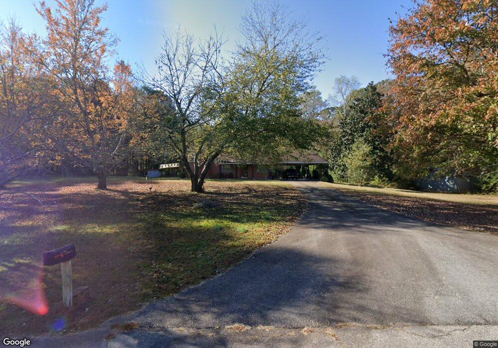
133 Faulk Rd Lagrange, GA 30240
Estimated Value: $152,000 - $181,000
3
Beds
1
Bath
1,026
Sq Ft
$164/Sq Ft
Est. Value
About This Home
This home is located at 133 Faulk Rd, Lagrange, GA 30240 and is currently estimated at $168,558, approximately $164 per square foot. 133 Faulk Rd is a home located in Troup County with nearby schools including Berta Weathersbee Elementary School, Whitesville Road Elementary School, and Long Cane Elementary School.
Ownership History
Date
Name
Owned For
Owner Type
Purchase Details
Closed on
Dec 20, 2016
Sold by
Arrington Glenda Ann
Bought by
Csx Transportation Inc
Current Estimated Value
Purchase Details
Closed on
Feb 24, 2012
Sold by
Arrington Ella Laverne
Bought by
Arrington Glenda Ann
Purchase Details
Closed on
Oct 1, 1986
Sold by
Troup Co Brd Of Commissioners
Bought by
Arrington Jimmy and Arrington Ella
Purchase Details
Closed on
Feb 22, 1980
Sold by
Sheppard Albert N and Sheppard Mary E
Bought by
Troup Co Brd Of Commissioners
Purchase Details
Closed on
Jan 1, 1961
Sold by
Charlie C Aldridge
Bought by
Sheppard Albert N and Sheppard Mary E
Create a Home Valuation Report for This Property
The Home Valuation Report is an in-depth analysis detailing your home's value as well as a comparison with similar homes in the area
Home Values in the Area
Average Home Value in this Area
Purchase History
| Date | Buyer | Sale Price | Title Company |
|---|---|---|---|
| Csx Transportation Inc | $10,000 | -- | |
| Arrington Glenda Ann | -- | -- | |
| Arrington Jimmy | -- | -- | |
| Troup Co Brd Of Commissioners | -- | -- | |
| Sheppard Albert N | -- | -- |
Source: Public Records
Tax History Compared to Growth
Tax History
| Year | Tax Paid | Tax Assessment Tax Assessment Total Assessment is a certain percentage of the fair market value that is determined by local assessors to be the total taxable value of land and additions on the property. | Land | Improvement |
|---|---|---|---|---|
| 2024 | $633 | $52,280 | $10,520 | $41,760 |
| 2023 | $196 | $47,400 | $10,520 | $36,880 |
| 2022 | $464 | $45,240 | $10,520 | $34,720 |
| 2021 | $295 | $35,960 | $13,200 | $22,760 |
| 2020 | $784 | $35,960 | $13,200 | $22,760 |
| 2019 | $786 | $36,040 | $13,200 | $22,840 |
| 2018 | $964 | $33,960 | $13,200 | $20,760 |
| 2017 | $964 | $33,960 | $13,200 | $20,760 |
| 2016 | $826 | $29,356 | $9,000 | $20,356 |
| 2015 | $816 | $28,996 | $9,000 | $19,996 |
| 2014 | $786 | $27,943 | $9,000 | $18,943 |
| 2013 | -- | $28,768 | $9,000 | $19,768 |
Source: Public Records
Map
Nearby Homes
- 141 Avery Dr
- 0 Unit 10514554
- 146 Whitaker Rd
- 37 Overbrook Dr
- 223 Pinehaven Dr
- 0 Bradfield Dr Unit 10568803
- 117 Brookwood Dr
- 509 Connie Dr
- 104 Spring Valley Dr
- 212 Aster Way
- 808 S Fling Rd
- 243 Oak Dr
- 200 Cheyenne Dr
- 190 Hill Rd
- 167 S Kight Dr
- 101 Crown St Unit LOT 5
- 102 Crown St Unit LOT 1
- The Rhodes Plan at Crown Street Cottages
- The Truitt Plan at Crown Street Cottages
- The Callaway Plan at Crown Street Cottages