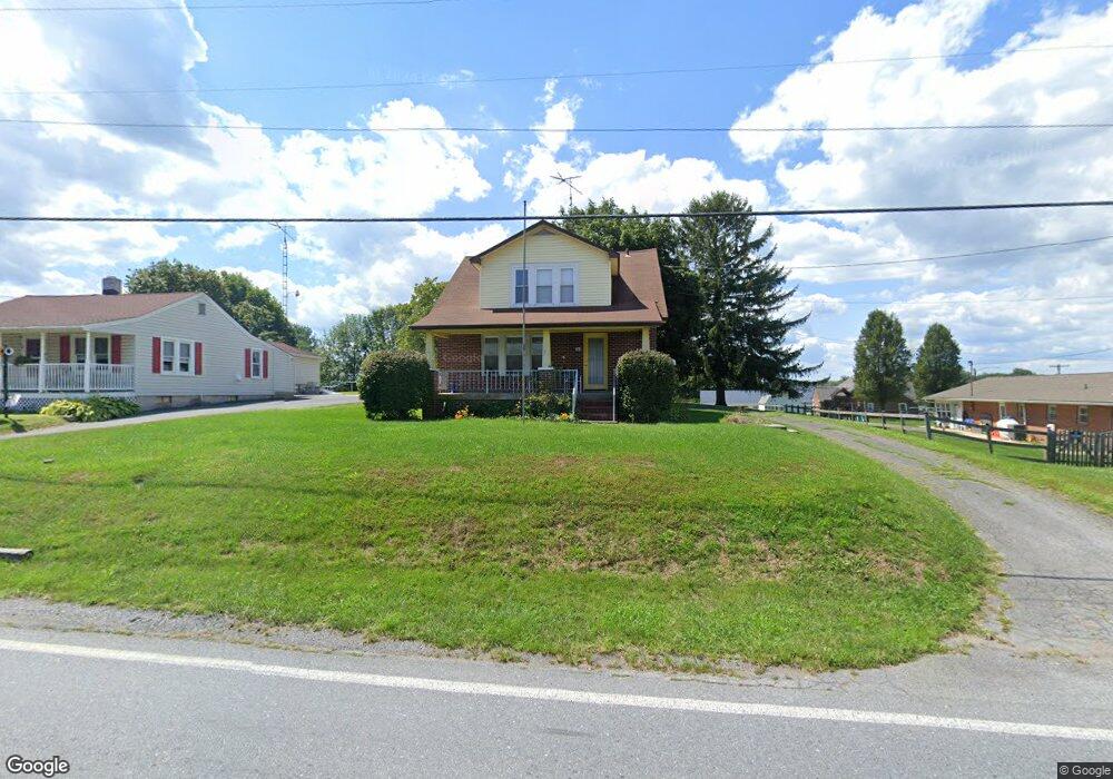
133 N Main St Union Bridge, MD 21791
Estimated Value: $306,000 - $338,000
3
Beds
2
Baths
1,418
Sq Ft
$226/Sq Ft
Est. Value
About This Home
This home is located at 133 N Main St, Union Bridge, MD 21791 and is currently estimated at $321,018, approximately $226 per square foot. 133 N Main St is a home located in Carroll County with nearby schools including Elmer A. Wolfe Elementary School, Northwest Middle School, and Francis Scott Key High School.
Ownership History
Date
Name
Owned For
Owner Type
Purchase Details
Closed on
Oct 27, 2005
Sold by
Mongold Kristi Wilson
Bought by
Henry Cortesini and Gibbons Matthew
Current Estimated Value
Purchase Details
Closed on
Oct 14, 2005
Sold by
Mongold Kristi Wilson
Bought by
Henry Cortesini and Gibbons Matthew
Purchase Details
Closed on
Mar 16, 2004
Sold by
Mongold Jerry Wayne
Bought by
Mongold Kristi Wilson
Purchase Details
Closed on
Nov 9, 1995
Sold by
Wilson Donald D
Bought by
Mongold Jerry Wayne and Mongold Kristi Wilson
Create a Home Valuation Report for This Property
The Home Valuation Report is an in-depth analysis detailing your home's value as well as a comparison with similar homes in the area
Home Values in the Area
Average Home Value in this Area
Purchase History
| Date | Buyer | Sale Price | Title Company |
|---|---|---|---|
| Henry Cortesini | $253,000 | -- | |
| Henry Cortesini | $253,000 | -- | |
| Mongold Kristi Wilson | -- | -- | |
| Mongold Jerry Wayne | -- | -- |
Source: Public Records
Tax History Compared to Growth
Tax History
| Year | Tax Paid | Tax Assessment Tax Assessment Total Assessment is a certain percentage of the fair market value that is determined by local assessors to be the total taxable value of land and additions on the property. | Land | Improvement |
|---|---|---|---|---|
| 2025 | $2,520 | $207,333 | $0 | $0 |
| 2024 | $2,520 | $183,067 | $0 | $0 |
| 2023 | $2,334 | $158,800 | $78,300 | $80,500 |
| 2022 | $2,314 | $157,467 | $0 | $0 |
| 2021 | $4,622 | $156,133 | $0 | $0 |
| 2020 | $2,291 | $154,800 | $78,300 | $76,500 |
| 2019 | $2,271 | $153,433 | $0 | $0 |
| 2018 | $2,235 | $152,067 | $0 | $0 |
| 2017 | $2,215 | $150,700 | $0 | $0 |
| 2016 | -- | $150,700 | $0 | $0 |
| 2015 | -- | $150,700 | $0 | $0 |
| 2014 | -- | $152,600 | $0 | $0 |
Source: Public Records
Map
Nearby Homes
- 147 Union Bridge Rd
- 11420 Green Valley Rd
- 45 N Main St
- 6 N Farquhar St
- 4939 Middleburg Rd
- 57B Hoff Rd
- 244 Stem Rd
- 430 Bucher John Rd
- 285 Stem Rd
- 0 Stem Rd
- 3875 Bark Hill Rd
- 12613 Good Intent Rd
- 6200 Middleburg Rd
- 0 Crouse Mill Rd Unit MDCR2028936
- 1450 Marble Quarry Rd
- 0 Crouse Mill
- 3459 Uniontown Rd
- 1309 Trevanion Rd
- 718 Francis Scott Key Hwy
- 1312 Bruceville Rd
- 131 N Main St
- 137 Union Bridge Rd
- 129 N Main St
- 128 N Main St
- 141 Union Bridge Rd
- 130 N Main St
- 128A N Main St
- 125 N Main St
- 143 Union Bridge Rd
- 126 N Main St
- 4877 Bark Hill Rd
- 136 Union Bridge Rd
- 138 Union Bridge Rd
- 123 N Main St
- 145 Union Bridge Rd
- 124 N Main St
- 4880 Bark Hill Rd
- 0 Union Bridge Rd Unit 1006847854
- 0 Union Bridge Rd Unit 1001934108
- 121 N Main St