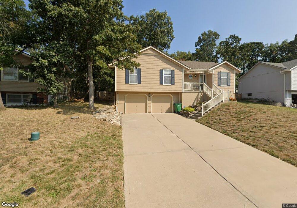
133 NW Whitlock Dr Lees Summit, MO 64081
Estimated Value: $341,861 - $373,000
3
Beds
2
Baths
1,632
Sq Ft
$219/Sq Ft
Est. Value
About This Home
This home is located at 133 NW Whitlock Dr, Lees Summit, MO 64081 and is currently estimated at $357,215, approximately $218 per square foot. 133 NW Whitlock Dr is a home located in Jackson County with nearby schools including Cedar Creek Elementary School, Pleasant Lea Middle School, and Lee's Summit Senior High School.
Ownership History
Date
Name
Owned For
Owner Type
Purchase Details
Closed on
May 23, 1997
Sold by
Associates Relocation Management Co Inc
Bought by
Moody Russell E
Current Estimated Value
Home Financials for this Owner
Home Financials are based on the most recent Mortgage that was taken out on this home.
Original Mortgage
$102,654
Outstanding Balance
$14,206
Interest Rate
8.12%
Mortgage Type
FHA
Estimated Equity
$343,009
Purchase Details
Closed on
Mar 13, 1997
Sold by
Horn Wayne G and Horn Jean P
Bought by
Associates Relocation Management Co Inc
Create a Home Valuation Report for This Property
The Home Valuation Report is an in-depth analysis detailing your home's value as well as a comparison with similar homes in the area
Home Values in the Area
Average Home Value in this Area
Purchase History
| Date | Buyer | Sale Price | Title Company |
|---|---|---|---|
| Moody Russell E | -- | -- | |
| Associates Relocation Management Co Inc | -- | -- |
Source: Public Records
Mortgage History
| Date | Status | Borrower | Loan Amount |
|---|---|---|---|
| Open | Moody Russell E | $102,654 |
Source: Public Records
Tax History Compared to Growth
Tax History
| Year | Tax Paid | Tax Assessment Tax Assessment Total Assessment is a certain percentage of the fair market value that is determined by local assessors to be the total taxable value of land and additions on the property. | Land | Improvement |
|---|---|---|---|---|
| 2025 | $4,018 | $51,260 | $8,643 | $42,617 |
| 2024 | $3,989 | $55,647 | $7,182 | $48,465 |
| 2023 | $3,989 | $55,648 | $6,808 | $48,840 |
| 2022 | $3,129 | $38,760 | $5,995 | $32,765 |
| 2021 | $3,194 | $38,760 | $5,995 | $32,765 |
| 2020 | $3,066 | $36,842 | $5,995 | $30,847 |
| 2019 | $2,982 | $36,842 | $5,995 | $30,847 |
| 2018 | $2,725 | $31,251 | $3,493 | $27,758 |
| 2017 | $2,725 | $31,251 | $3,493 | $27,758 |
| 2016 | $2,565 | $29,108 | $4,161 | $24,947 |
| 2014 | $2,465 | $27,426 | $4,153 | $23,273 |
Source: Public Records
Map
Nearby Homes
- 2237 NW Killarney Ln
- 2214 NW Killarney Ln
- 19 SW Whitlock Dr
- 2123 NW Killarney Ln
- 361 NW Patch Ct
- 2108 NW Shamrock Ave
- 248 SW Winterpark Cir
- 2090 NW O'Brien Rd
- 2086 NW O'Brien Rd
- Monterey Plan at Reserve at Woodside Ridge
- Oakleigh Plan at Reserve at Woodside Ridge
- Ashland Plan at Reserve at Woodside Ridge
- Bentley Plan at Reserve at Woodside Ridge
- Mariah Plan at Reserve at Woodside Ridge
- Oakshire Plan at Reserve at Woodside Ridge
- Forrester II Plan at Reserve at Woodside Ridge
- Forrester 2824 Plan at Reserve at Woodside Ridge
- Regency Plan at Reserve at Woodside Ridge
- Windsong Plan at Reserve at Woodside Ridge
- Carolina Plan at Reserve at Woodside Ridge
- 129 NW Whitlock Dr
- 137 NW Whitlock Dr
- 132 NW Whitlock Dr
- 128 NW Whitlock Dr
- 136 NW Whitlock Dr
- 125 NW Whitlock Dr
- 124 NW Whitlock Dr
- 144 NW Whitlock Dr
- 140 NW Whitlock Dr
- 101 NW Cody Dr
- 105 NW Cody Dr
- 148 NW Whitlock Dr
- 121 NW Whitlock Dr
- 116 NW Whitlock Dr
- 152 NW Whitlock Dr
- 113 NW Cody Dr
- 112 NW Whitlock Dr
- 117 NW Whitlock Dr
- 104 NW Cody Dr
- 112 NW Cody Dr