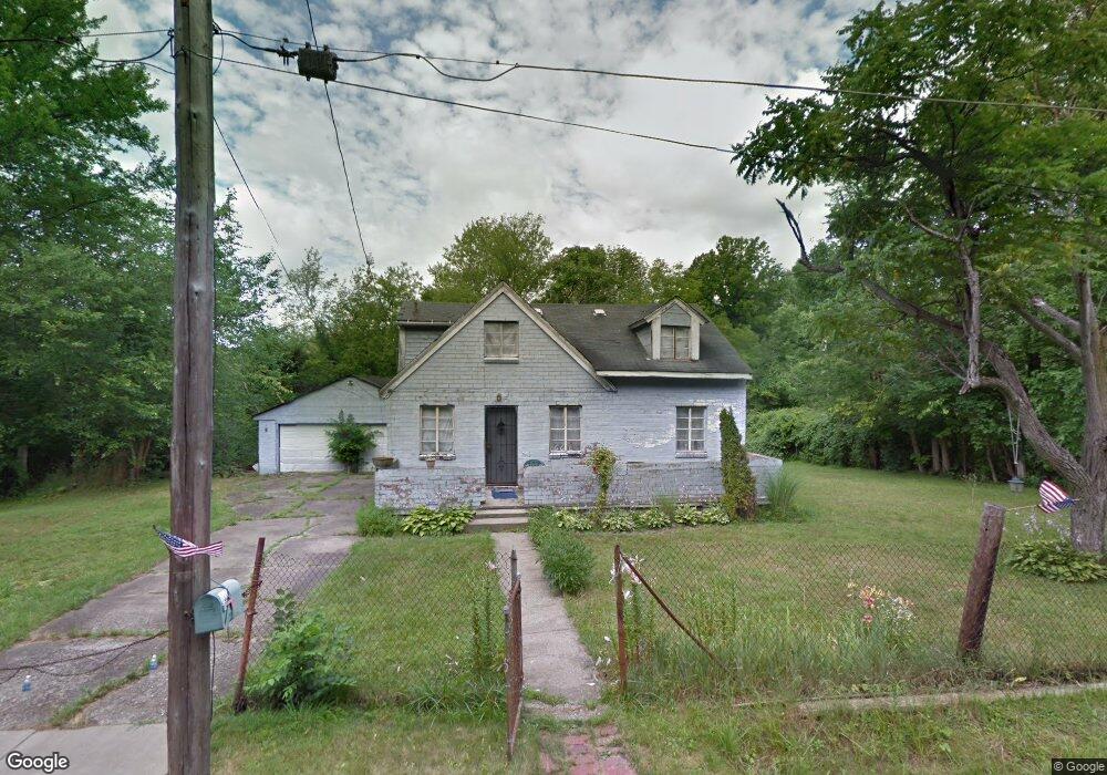
1330 Hanover St Youngstown, OH 44505
McGuffey Heights NeighborhoodEstimated Value: $56,674 - $88,000
2
Beds
1
Bath
1,173
Sq Ft
$60/Sq Ft
Est. Value
About This Home
This home is located at 1330 Hanover St, Youngstown, OH 44505 and is currently estimated at $70,169, approximately $59 per square foot. 1330 Hanover St is a home located in Mahoning County with nearby schools including M.L. King Elementary School, Williamson Elementary School, and East High School.
Ownership History
Date
Name
Owned For
Owner Type
Purchase Details
Closed on
Apr 17, 2024
Sold by
Sanders Denise
Bought by
Berger Occie
Current Estimated Value
Purchase Details
Closed on
Jul 2, 1999
Sold by
Mcelroy Damond
Bought by
Sanders Uriah K
Purchase Details
Closed on
Dec 10, 1997
Sold by
Desoto Gilbert P
Bought by
Mcelray Danan
Purchase Details
Closed on
Dec 2, 1996
Sold by
Boatwright Ethel
Bought by
Desato Gilbert
Purchase Details
Closed on
Aug 14, 1986
Bought by
Boatwright Ethel
Create a Home Valuation Report for This Property
The Home Valuation Report is an in-depth analysis detailing your home's value as well as a comparison with similar homes in the area
Home Values in the Area
Average Home Value in this Area
Purchase History
| Date | Buyer | Sale Price | Title Company |
|---|---|---|---|
| Berger Occie | $3,000 | None Listed On Document | |
| Sanders Uriah K | $900 | -- | |
| Mcelray Danan | $1,000 | -- | |
| Desato Gilbert | $9,000 | -- | |
| Boatwright Ethel | -- | -- |
Source: Public Records
Tax History Compared to Growth
Tax History
| Year | Tax Paid | Tax Assessment Tax Assessment Total Assessment is a certain percentage of the fair market value that is determined by local assessors to be the total taxable value of land and additions on the property. | Land | Improvement |
|---|---|---|---|---|
| 2024 | $262 | $5,320 | $550 | $4,770 |
| 2023 | $261 | $470 | $110 | $360 |
| 2022 | $34 | $470 | $110 | $360 |
| 2021 | $33 | $470 | $110 | $360 |
| 2020 | $33 | $470 | $110 | $360 |
| 2019 | $37 | $440 | $110 | $330 |
| 2018 | $43 | $440 | $110 | $330 |
| 2017 | $32 | $440 | $110 | $330 |
| 2016 | $30 | $410 | $110 | $300 |
| 2015 | $31 | $410 | $110 | $300 |
| 2014 | $29 | $410 | $110 | $300 |
| 2013 | $29 | $410 | $110 | $300 |
Source: Public Records
Map
Nearby Homes
- 1214 Brighton St
- 1720 Jacobs Rd
- 1003 Liberty Rd
- 2051 Blair Ave
- 2951 Megan Cir
- V/L Jacobs Rd
- 2831 Benford Ln
- 2954 Megan Cir
- 1325 Miami Ave
- 902 Miami St
- 227 Greeley Ln
- 1538 Republic Ave
- 405 Drake Ave
- 665 Wendemere Dr
- 566 Sunshine Ave
- 71 Duncan Ln
- 0 Homestead Rd
- 663 Meadowland Dr
- 366 Westview Ave
- 332 Lansdowne Blvd
- 1348 Burford St
- 1320 Jacobs Rd
- 2971 Edgar Ave
- 2928 Arcadia Ave
- 1335 Dundee St
- 2939 Edgar Ave
- 1520 Jacobs Rd
- 2920 Arcadia Ave
- 1526 Jacobs Rd
- 1331 Jacobs Rd
- 1320 Dundee St
- 1306 Dundee St
- 1515 Jacobs Rd
- 1602 Jacobs Rd
- 2972 Edgar Ave
- 2974 Edgar Ave
- 1519 Jacobs Rd
- 2920 Cantwell Ave
- 0 Jacobs Rd
- 2944 Edgar Ave