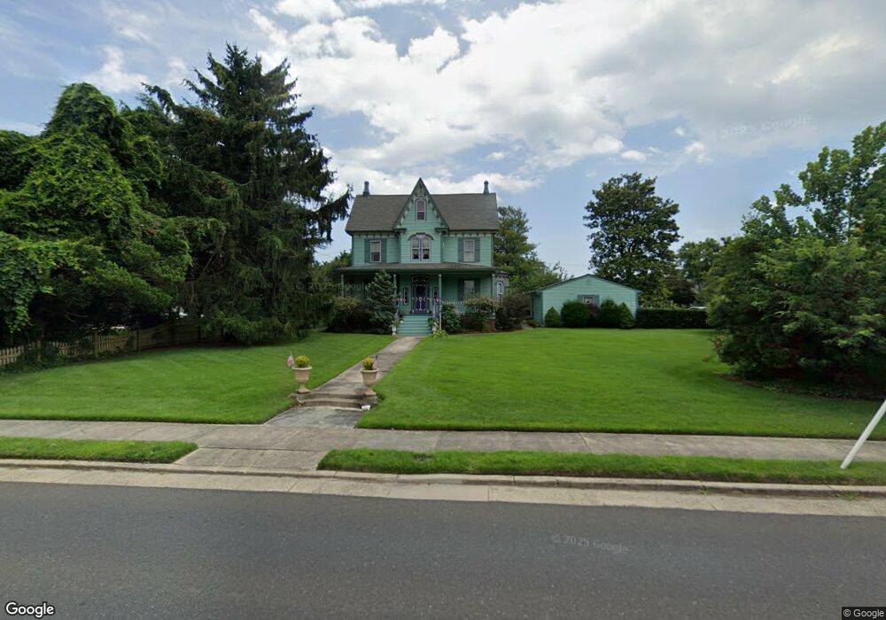
1330 Shore Rd Linwood, NJ 08221
Estimated Value: $582,839 - $978,000
6
Beds
3
Baths
2,700
Sq Ft
$265/Sq Ft
Est. Value
About This Home
This home is located at 1330 Shore Rd, Linwood, NJ 08221 and is currently estimated at $715,710, approximately $265 per square foot. 1330 Shore Rd is a home located in Atlantic County with nearby schools including Seaview Elementary School, Belhaven Middle School, and Mainland Regional High School.
Ownership History
Date
Name
Owned For
Owner Type
Purchase Details
Closed on
Aug 25, 2017
Sold by
Fattori Frank and Fattori Marietta
Bought by
Kaye Faith
Current Estimated Value
Home Financials for this Owner
Home Financials are based on the most recent Mortgage that was taken out on this home.
Original Mortgage
$284,747
Outstanding Balance
$238,166
Interest Rate
3.96%
Mortgage Type
FHA
Estimated Equity
$477,544
Purchase Details
Closed on
Sep 30, 1994
Sold by
Mahoney James
Bought by
Fattori Frank and Fattori Marietta
Purchase Details
Closed on
Dec 15, 1988
Sold by
Shaw Clifton D and Shaw Meta E
Bought by
Mahoney James M and Mahoney Caywood,Linda D
Create a Home Valuation Report for This Property
The Home Valuation Report is an in-depth analysis detailing your home's value as well as a comparison with similar homes in the area
Home Values in the Area
Average Home Value in this Area
Purchase History
| Date | Buyer | Sale Price | Title Company |
|---|---|---|---|
| Kaye Faith | $290,000 | Agents Title Llc | |
| Fattori Frank | $245,000 | -- | |
| Mahoney James M | $175,000 | -- |
Source: Public Records
Mortgage History
| Date | Status | Borrower | Loan Amount |
|---|---|---|---|
| Open | Kaye Faith | $284,747 |
Source: Public Records
Tax History Compared to Growth
Tax History
| Year | Tax Paid | Tax Assessment Tax Assessment Total Assessment is a certain percentage of the fair market value that is determined by local assessors to be the total taxable value of land and additions on the property. | Land | Improvement |
|---|---|---|---|---|
| 2025 | $11,445 | $300,000 | $80,000 | $220,000 |
| 2024 | $11,445 | $300,000 | $80,000 | $220,000 |
| 2023 | $10,914 | $300,000 | $80,000 | $220,000 |
| 2022 | $10,914 | $300,000 | $80,000 | $220,000 |
| 2021 | $10,818 | $300,000 | $80,000 | $220,000 |
| 2020 | $10,668 | $300,000 | $80,000 | $220,000 |
| 2019 | $10,440 | $300,000 | $80,000 | $220,000 |
| 2018 | $10,206 | $300,000 | $80,000 | $220,000 |
| 2017 | $13,116 | $393,400 | $104,200 | $289,200 |
| 2016 | $12,425 | $393,400 | $104,200 | $289,200 |
| 2015 | $12,437 | $393,400 | $104,200 | $289,200 |
| 2014 | $11,989 | $394,800 | $104,200 | $290,600 |
Source: Public Records
Map
Nearby Homes
- 7 Woodstock Dr
- 1201 Woodlynne Blvd
- 209 Berkshire Ave
- 1917 Ventnor Ave
- 102 Morris Ave
- 208 Balfour Ave
- 103 E Patcong Ave
- 110 E Patcong Ave
- 1610 Shore Rd
- 1610 Woodlynne Blvd
- 108 Holly Ln
- 1050 Shore Rd
- 105 W Edgewood Ave
- 209 Belhaven Ave
- 4 Princeton Ln
- 1016 Richard Dr
- 1011 New Rd
- 110 E Seaview Ave
- 104 W Poplar Ave
- 110 W Poplar Ave
- 5 Cambridge Ave
- 6 Berkshire Ave
- 1406 Shore Rd
- 8 Berkshire Ave
- 1331 Shore Rd
- 1410 Shore Rd
- 17 Cambridge Ave
- 1333 Shore Rd
- 5 Berkshire Ave
- 1401 Shore Rd
- 2 Cambridge Ave
- 20 Cambridge Ave
- 1325 Woodlynne Blvd
- 1305 Shore Rd
- 1315 Woodlynne Blvd
- 1401 Woodlynne Blvd
- 1418 Shore Rd
- 10 Ireland Ave
- 2 Woodstock Dr
- 1419 Shore Rd