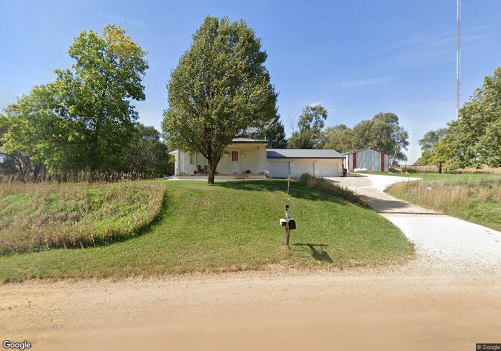
1337 Buchanan Ave Sioux City, IA 51106
Estimated Value: $319,000 - $352,000
3
Beds
3
Baths
1,640
Sq Ft
$202/Sq Ft
Est. Value
About This Home
This home is located at 1337 Buchanan Ave, Sioux City, IA 51106 and is currently estimated at $330,706, approximately $201 per square foot. 1337 Buchanan Ave is a home located in Woodbury County with nearby schools including Bronson Elementary School and Lawton Junior/Senior High School.
Ownership History
Date
Name
Owned For
Owner Type
Purchase Details
Closed on
Sep 23, 2022
Sold by
Ricklefs Angela J and Ricklefs Benjamin J
Bought by
Ricklefs Angela J and Ricklefs Benjamin J
Current Estimated Value
Home Financials for this Owner
Home Financials are based on the most recent Mortgage that was taken out on this home.
Original Mortgage
$113,500
Outstanding Balance
$96,874
Interest Rate
4.85%
Mortgage Type
New Conventional
Estimated Equity
$233,832
Create a Home Valuation Report for This Property
The Home Valuation Report is an in-depth analysis detailing your home's value as well as a comparison with similar homes in the area
Home Values in the Area
Average Home Value in this Area
Purchase History
| Date | Buyer | Sale Price | Title Company |
|---|---|---|---|
| Ricklefs Angela J | -- | -- |
Source: Public Records
Mortgage History
| Date | Status | Borrower | Loan Amount |
|---|---|---|---|
| Open | Ricklefs Angela J | $113,500 |
Source: Public Records
Tax History Compared to Growth
Tax History
| Year | Tax Paid | Tax Assessment Tax Assessment Total Assessment is a certain percentage of the fair market value that is determined by local assessors to be the total taxable value of land and additions on the property. | Land | Improvement |
|---|---|---|---|---|
| 2025 | $2,466 | $272,210 | $66,000 | $206,210 |
| 2024 | $2,466 | $248,710 | $44,000 | $204,710 |
| 2023 | $2,516 | $248,710 | $44,000 | $204,710 |
| 2022 | $2,820 | $206,110 | $44,000 | $162,110 |
| 2021 | $2,820 | $206,110 | $44,000 | $162,110 |
| 2020 | $2,622 | $186,450 | $47,080 | $139,370 |
| 2019 | $2,350 | $186,450 | $47,080 | $139,370 |
| 2018 | $2,282 | $160,240 | $20,870 | $139,370 |
| 2017 | $2,282 | $160,240 | $20,870 | $139,370 |
| 2016 | $2,170 | $148,110 | $0 | $0 |
| 2015 | $2,141 | $138,420 | $19,500 | $118,920 |
| 2014 | $2,138 | $138,420 | $19,500 | $118,920 |
Source: Public Records
Map
Nearby Homes
- 3700 28th St Unit 335
- 1120 Meadow View Ct Unit 3
- 1220 Saint Marys St
- 5641 S Roswell St
- 5651 S Roswell St
- 5208 Laurel Ave
- 3221 11th St
- 1830 S Maple St
- 1909 S Olive St
- 2564 Nicklaus Blvd
- 4509 Floyd Blvd
- 1502 S Clinton St
- 2600 Nicklaus Blvd
- 1815 S Lemon St
- 2640 Nicklaus Blvd
- TBD Outer Dr N
- 2024 S Maple St
- 6290 Tiger Dr
- 301 Logan St
- 115 S Paxton St
- 1349 Buchanan Ave
- 1336 Buchanan Ave
- 1328 Buchanan Ave
- 1323 Buchanan Ave
- 1358 Buchanan Ave
- 1324 Buchanan Ave
- 1353 Buchanan Ave
- 1373 Buchanan Ave
- 1378 Buchanan Ave
- 1317 Buchanan Ave
- 1320 Buchanan Ave
- 1379 Buchanan Ave
- 1384 Buchanan Ave
- 1392 Buchanan Ave
- 1275 Buchanan Ave
- 1271 Buchanan Ave
- 1523 140th St
- 1274 Buchanan Ave
- 1558 140th St
- 1536 140th St