Estimated Value: $292,000 - $331,000
4
Beds
2
Baths
1,600
Sq Ft
$194/Sq Ft
Est. Value
About This Home
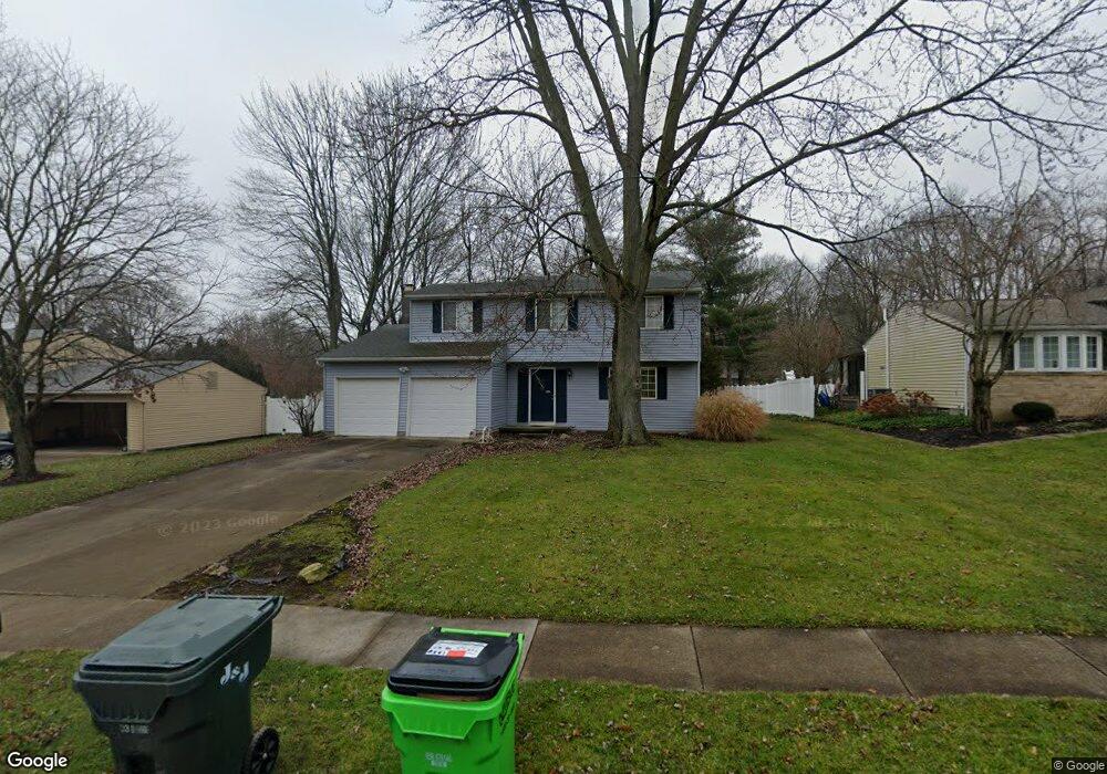
This home is located at 1339 Homesite Dr, Stow, OH 44224 and is currently estimated at $309,640, approximately $193 per square foot. 1339 Homesite Dr is a home located in Summit County with nearby schools including Stow-Munroe Falls High School, Primrose School of Hudson, and Holy Family Elementary School.
Ownership History
Date
Name
Owned For
Owner Type
Purchase Details
Closed on
Feb 16, 2008
Sold by
Miller Bernard W and Miller Paula J
Bought by
Stefanovic Sharon R
Current Estimated Value
Home Financials for this Owner
Home Financials are based on the most recent Mortgage that was taken out on this home.
Original Mortgage
$122,800
Outstanding Balance
$76,808
Interest Rate
5.9%
Mortgage Type
Purchase Money Mortgage
Estimated Equity
$232,832
Purchase Details
Closed on
Feb 29, 1996
Sold by
Mccrady Timothy D
Bought by
Miller Bernard and Miller Paula J
Home Financials for this Owner
Home Financials are based on the most recent Mortgage that was taken out on this home.
Original Mortgage
$74,500
Interest Rate
7.07%
Mortgage Type
New Conventional
Create a Home Valuation Report for This Property
The Home Valuation Report is an in-depth analysis detailing your home's value as well as a comparison with similar homes in the area
Home Values in the Area
Average Home Value in this Area
Purchase History
| Date | Buyer | Sale Price | Title Company |
|---|---|---|---|
| Stefanovic Sharon R | $153,500 | Multiple | |
| Miller Bernard | $127,500 | -- |
Source: Public Records
Mortgage History
| Date | Status | Borrower | Loan Amount |
|---|---|---|---|
| Open | Stefanovic Sharon R | $122,800 | |
| Previous Owner | Miller Bernard | $74,500 |
Source: Public Records
Tax History Compared to Growth
Tax History
| Year | Tax Paid | Tax Assessment Tax Assessment Total Assessment is a certain percentage of the fair market value that is determined by local assessors to be the total taxable value of land and additions on the property. | Land | Improvement |
|---|---|---|---|---|
| 2025 | $5,153 | $91,441 | $11,830 | $79,611 |
| 2024 | $5,153 | $91,441 | $11,830 | $79,611 |
| 2023 | $5,153 | $91,441 | $11,830 | $79,611 |
| 2021 | $4,032 | $70,480 | $9,100 | $61,380 |
| 2020 | $3,962 | $70,480 | $9,100 | $61,380 |
| 2019 | $3,640 | $60,450 | $9,100 | $51,350 |
| 2018 | $3,581 | $60,450 | $9,100 | $51,350 |
| 2017 | $3,246 | $60,450 | $9,100 | $51,350 |
| 2016 | $3,341 | $53,170 | $9,100 | $44,070 |
| 2015 | $3,246 | $53,170 | $9,100 | $44,070 |
| 2014 | $3,249 | $53,170 | $9,100 | $44,070 |
| 2013 | $2,821 | $46,330 | $9,100 | $37,230 |
Source: Public Records
Map
Nearby Homes
- 1470 Mac Dr
- 0 Hibbard Dr
- 1511 Apollo Dr
- 4877 Cedar Crest Ln
- 4891 Cedar Crest Ln
- 1808 Higby Dr Unit A
- V/L Lawnmark Dr
- 1664 Cypress Ct
- V/L Housley Rd
- 1627 Cypress Ct
- 1938 Higby Dr
- 4630 Red Willow Rd
- 1620 Sapphire Dr
- 1884 Village Ct Unit X66
- V/L Norton Rd
- 2327 Crockett Cir
- 0 Stow Rd Unit 5102979
- 4024 Glenrich Cir
- V/L Diplomat Dr
- 5217 Beckett Ridge
- 1333 Homesite Dr
- 1347 Homesite Dr
- 1355 Homesite Dr
- 1325 Homesite Dr
- 1340 Homesite Dr
- 4748 Sunnyside Dr
- 1332 Homesite Dr
- 1405 Cherokee Trail
- 1324 Homesite Dr
- 4740 Sunnyside Dr
- 1319 Homesite Dr
- 4770 Sunnyside Dr
- 1420 Cherokee Trail
- 4760 Sunnyside Dr
- 1314 Homesite Dr
- 1395 Cherokee Trail
- 4730 Sunnyside Dr
- 1416 Cherokee Trail
- 5000 Commanche Trail
- 1410 Cherokee Trail