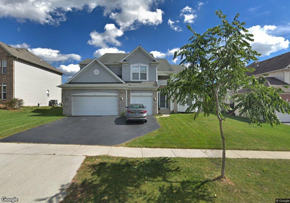
1339 Maple Cir Unit 1 West Dundee, IL 60118
Estimated Value: $510,488 - $567,000
4
Beds
--
Bath
2,767
Sq Ft
$192/Sq Ft
Est. Value
About This Home
This home is located at 1339 Maple Cir Unit 1, West Dundee, IL 60118 and is currently estimated at $532,622, approximately $192 per square foot. 1339 Maple Cir Unit 1 is a home located in Kane County with nearby schools including Dundee Highlands Elementary School, Dundee Middle School, and West Prairie Middle School.
Ownership History
Date
Name
Owned For
Owner Type
Purchase Details
Closed on
Apr 2, 2004
Sold by
Grand Pointe Meadows Llc
Bought by
Kwak Sung Gun and Kwak Mees
Current Estimated Value
Home Financials for this Owner
Home Financials are based on the most recent Mortgage that was taken out on this home.
Original Mortgage
$200,000
Outstanding Balance
$83,126
Interest Rate
4%
Mortgage Type
Purchase Money Mortgage
Estimated Equity
$449,496
Create a Home Valuation Report for This Property
The Home Valuation Report is an in-depth analysis detailing your home's value as well as a comparison with similar homes in the area
Home Values in the Area
Average Home Value in this Area
Purchase History
| Date | Buyer | Sale Price | Title Company |
|---|---|---|---|
| Kwak Sung Gun | $383,500 | Ticor Title Insurance Compan |
Source: Public Records
Mortgage History
| Date | Status | Borrower | Loan Amount |
|---|---|---|---|
| Open | Kwak Sung Gun | $200,000 |
Source: Public Records
Tax History Compared to Growth
Tax History
| Year | Tax Paid | Tax Assessment Tax Assessment Total Assessment is a certain percentage of the fair market value that is determined by local assessors to be the total taxable value of land and additions on the property. | Land | Improvement |
|---|---|---|---|---|
| 2024 | $11,111 | $144,311 | $25,730 | $118,581 |
| 2023 | $10,427 | $129,846 | $23,151 | $106,695 |
| 2022 | $10,387 | $123,906 | $23,151 | $100,755 |
| 2021 | $10,029 | $116,992 | $21,859 | $95,133 |
| 2020 | $9,846 | $114,362 | $21,368 | $92,994 |
| 2019 | $10,547 | $119,457 | $20,285 | $99,172 |
| 2018 | $10,217 | $113,129 | $19,883 | $93,246 |
| 2017 | $9,739 | $105,827 | $18,600 | $87,227 |
| 2016 | $9,931 | $102,466 | $18,009 | $84,457 |
| 2015 | -- | $96,847 | $21,296 | $75,551 |
| 2014 | -- | $94,173 | $20,708 | $73,465 |
| 2013 | -- | $97,056 | $21,342 | $75,714 |
Source: Public Records
Map
Nearby Homes
- 36W461 Binnie Rd
- 36W340 Huntley Rd
- 1601 Higgins Rd
- 36W690 Winding Trail
- 6850 Huntley Rd
- lot 009 Huntley Rd
- 8022 Sierra Woods Ln Unit 8022
- Marianne Plan at Hickory Glen
- Charlotte Plan at Hickory Glen
- 812 Lindsay Ln
- 822 Lindsay Ln
- 814 Lindsay Ln
- 816 Lindsay Ln
- 813 Lindsay Ln
- 825 Lindsay Ln
- 818 Lindsay Ln
- 1023 Shagbark Ln
- 1031 Shagbark Ln
- 1715 W Main St
- 8304 Sierra Woods Ln Unit 8304
- 1341 Maple Cir
- 1327 Maple Cir Unit 1
- 1336 Karen Dr
- 1351 Maple Cir Unit 1
- 1315 Maple Cir Unit 1
- 1348 Karen Dr
- 1324 Karen Dr
- 1326 Maple Cir
- 1340 Maple Cir
- 1358 Karen Dr
- 1363 Maple Cir
- 1303 Maple Cir
- 1312 Karen Dr
- 2600 Oak Dr
- 1304 Karen Dr
- 1375 Maple Cir Unit 1
- 1362 Karen Dr
- 1301 Maple Cir
- 2602 Oak Dr
- 1383 Acorn Ct