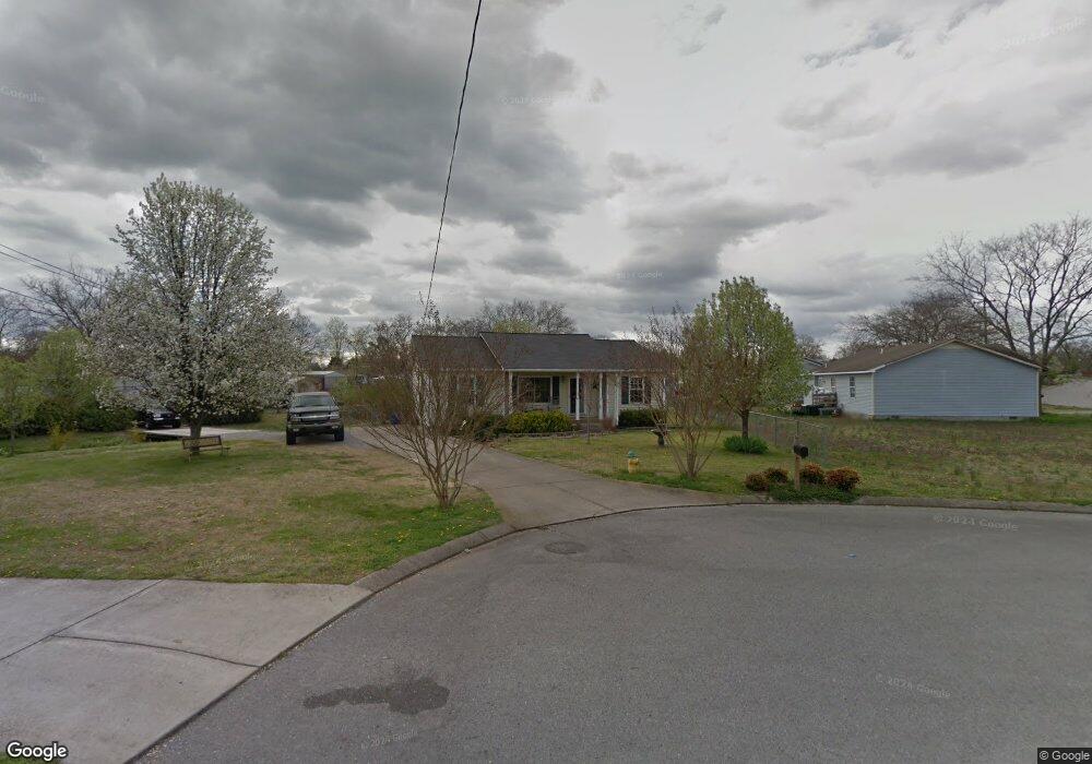
134 Adams Ct La Vergne, TN 37086
Estimated Value: $269,774 - $311,000
--
Bed
2
Baths
1,084
Sq Ft
$274/Sq Ft
Est. Value
About This Home
This home is located at 134 Adams Ct, La Vergne, TN 37086 and is currently estimated at $296,944, approximately $273 per square foot. 134 Adams Ct is a home located in Rutherford County with nearby schools including Roy L. Waldron Elementary School, Lavergne Primary School, and La Vergne Middle School.
Ownership History
Date
Name
Owned For
Owner Type
Purchase Details
Closed on
May 7, 1999
Sold by
Plunkett Tammy R
Bought by
Singleton Walter F and Singleton Tammy
Current Estimated Value
Home Financials for this Owner
Home Financials are based on the most recent Mortgage that was taken out on this home.
Original Mortgage
$89,100
Outstanding Balance
$22,946
Interest Rate
7%
Estimated Equity
$273,998
Purchase Details
Closed on
Jun 5, 1998
Sold by
Plunkett Tammy R
Bought by
Plunkett Tammy R
Purchase Details
Closed on
Apr 4, 1994
Sold by
Allen Plunkett David
Bought by
Renee Plunkett Tammy
Create a Home Valuation Report for This Property
The Home Valuation Report is an in-depth analysis detailing your home's value as well as a comparison with similar homes in the area
Home Values in the Area
Average Home Value in this Area
Purchase History
| Date | Buyer | Sale Price | Title Company |
|---|---|---|---|
| Singleton Walter F | -- | -- | |
| Plunkett Tammy R | -- | -- | |
| Renee Plunkett Tammy | -- | -- |
Source: Public Records
Mortgage History
| Date | Status | Borrower | Loan Amount |
|---|---|---|---|
| Open | Renee Plunkett Tammy | $89,100 |
Source: Public Records
Tax History Compared to Growth
Tax History
| Year | Tax Paid | Tax Assessment Tax Assessment Total Assessment is a certain percentage of the fair market value that is determined by local assessors to be the total taxable value of land and additions on the property. | Land | Improvement |
|---|---|---|---|---|
| 2025 | $1,440 | $59,675 | $13,750 | $45,925 |
| 2024 | $1,440 | $59,675 | $13,750 | $45,925 |
| 2023 | $1,120 | $59,675 | $13,750 | $45,925 |
| 2022 | $964 | $59,675 | $13,750 | $45,925 |
| 2021 | $810 | $36,500 | $8,750 | $27,750 |
| 2020 | $810 | $36,500 | $8,750 | $27,750 |
| 2019 | $810 | $36,500 | $8,750 | $27,750 |
| 2018 | $1,025 | $36,500 | $0 | $0 |
| 2017 | $952 | $26,225 | $0 | $0 |
| 2016 | $952 | $26,225 | $0 | $0 |
| 2015 | $959 | $26,225 | $0 | $0 |
| 2014 | $652 | $26,225 | $0 | $0 |
| 2013 | -- | $24,725 | $0 | $0 |
Source: Public Records
Map
Nearby Homes
- 613 Sycamore Ln
- 1119 Moss Trail
- 403 Independence Ct
- 2015 Keaton Dr
- 306 Cotton Ct
- 4237 Miranda Place
- 102 Freeboard Alley
- 6724 Birchbrook Dr
- 7511 Cash Crossing Ct
- 150 Bluegill Ln
- 143 Bluegill Ln
- 152 Bluegill Ln
- 149 Bluegill Ln
- 148 Bluegill Ln
- 7543 Cash Crossing Ct
- 4414 Maxwell Rd
- ELSTON Plan at Percy Cove
- CALHOUN Plan at Percy Cove
- IRWIN Plan at Percy Cove
- EDMON Plan at Percy Cove
- 132 Constitution Ave
- 136 Adams Ct
- 613 Willowview Dr
- 130 Constitution Ave
- 615 Willowview Dr
- 611 Willowview Dr
- 609 Willowview Dr
- 617 Willowview Dr
- 140 Constitution Ave
- 138 Adams Ct
- 128 Constitution Ave
- 619 Willowview Dr
- 607 Willowview Dr
- 1091 Moss Trail
- 621 Willowview Dr
- 135 Constitution Ave
- 142 Constitution Ave
- 137 Constitution Ave
- 131 Constitution Ave
- 605 Willowview Dr