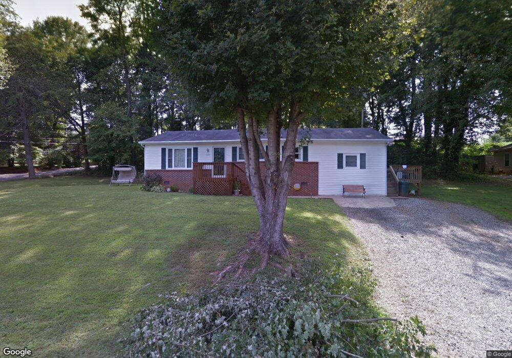
134 Lane St Morganton, NC 28655
Estimated Value: $191,000 - $220,000
3
Beds
1
Bath
1,404
Sq Ft
$144/Sq Ft
Est. Value
About This Home
This home is located at 134 Lane St, Morganton, NC 28655 and is currently estimated at $202,426, approximately $144 per square foot. 134 Lane St is a home located in Burke County with nearby schools including Forest Hill Elementary School, Liberty Middle School, and Robert L. Patton High School.
Ownership History
Date
Name
Owned For
Owner Type
Purchase Details
Closed on
Sep 18, 2008
Sold by
D & D Investment Builders Inc
Bought by
Williams Tonya Denise
Current Estimated Value
Home Financials for this Owner
Home Financials are based on the most recent Mortgage that was taken out on this home.
Original Mortgage
$70,000
Outstanding Balance
$43,637
Interest Rate
5.25%
Mortgage Type
Purchase Money Mortgage
Estimated Equity
$158,789
Purchase Details
Closed on
Sep 6, 2007
Sold by
Deutsche Bank National Trust Co
Bought by
D & D Investment Buidlers Inc
Create a Home Valuation Report for This Property
The Home Valuation Report is an in-depth analysis detailing your home's value as well as a comparison with similar homes in the area
Home Values in the Area
Average Home Value in this Area
Purchase History
| Date | Buyer | Sale Price | Title Company |
|---|---|---|---|
| Williams Tonya Denise | $69,000 | None Available | |
| D & D Investment Buidlers Inc | -- | None Available |
Source: Public Records
Mortgage History
| Date | Status | Borrower | Loan Amount |
|---|---|---|---|
| Open | Williams Tonya Denise | $70,000 |
Source: Public Records
Tax History Compared to Growth
Tax History
| Year | Tax Paid | Tax Assessment Tax Assessment Total Assessment is a certain percentage of the fair market value that is determined by local assessors to be the total taxable value of land and additions on the property. | Land | Improvement |
|---|---|---|---|---|
| 2025 | $690 | $106,900 | $17,010 | $89,890 |
| 2024 | $692 | $106,900 | $17,010 | $89,890 |
| 2023 | $687 | $106,900 | $17,010 | $89,890 |
| 2022 | $562 | $69,011 | $12,600 | $56,411 |
| 2021 | $556 | $69,011 | $12,600 | $56,411 |
| 2020 | $552 | $69,011 | $12,600 | $56,411 |
| 2019 | $552 | $69,011 | $12,600 | $56,411 |
| 2018 | $536 | $66,824 | $12,600 | $54,224 |
| 2017 | $534 | $66,824 | $12,600 | $54,224 |
| 2016 | $519 | $66,824 | $12,600 | $54,224 |
| 2015 | $516 | $66,824 | $12,600 | $54,224 |
Source: Public Records
Map
Nearby Homes
- Lot 2 Lane St Unit 2
- Lot 5 Lane St Unit 5
- Lot 6 Lane St Unit 6
- Lot 4 Lane St Unit 4
- Lot 3 Lane St Unit 3
- 106 Lane St Unit 6
- 0 Coffey St
- 207 Stacy St
- 421 Bethel Rd
- 103 Ramsey St
- 0 Coal Shute Rd Unit CAR3935533
- 107 Oakwood St
- 102 Castlegate Dr
- 107 N Matthews St
- 211 Hilltop St
- 302 White St
- 203 Beacon Ave
- 00000 Knollwood Dr
- VL E Concord St
- 102 Stephens Dr