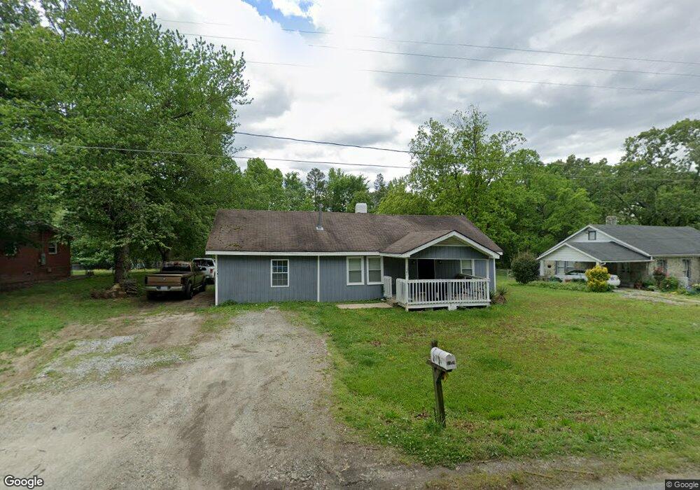
1340 Cox Ave High Point, NC 27263
Estimated Value: $85,929 - $150,000
2
Beds
1
Bath
850
Sq Ft
$129/Sq Ft
Est. Value
About This Home
This home is located at 1340 Cox Ave, High Point, NC 27263 and is currently estimated at $109,482, approximately $128 per square foot. 1340 Cox Ave is a home located in Guilford County with nearby schools including Allen Jay Elementary School, Southern Guilford Middle, and Southern Guilford High School.
Ownership History
Date
Name
Owned For
Owner Type
Purchase Details
Closed on
Nov 10, 2025
Sold by
Fabian Deharo Luis Fernando and Rivera Flores Maria
Bought by
De Haro Luis Fernando Fab
Current Estimated Value
Purchase Details
Closed on
Oct 22, 2021
Sold by
Miller Kenneth A and Miller Julie A
Bought by
Deharo Luis Fernando Fabian and Fabian Maria Guadalupe
Purchase Details
Closed on
Jul 20, 2006
Sold by
Kallam Dennis
Bought by
Miller Kenneth A and Miller Julie A
Home Financials for this Owner
Home Financials are based on the most recent Mortgage that was taken out on this home.
Original Mortgage
$52,510
Interest Rate
6.54%
Mortgage Type
Purchase Money Mortgage
Purchase Details
Closed on
Mar 31, 2005
Sold by
Fowler James W and Fowler Hazel L
Bought by
Kallam Dennis
Home Financials for this Owner
Home Financials are based on the most recent Mortgage that was taken out on this home.
Original Mortgage
$46,500
Interest Rate
10.11%
Mortgage Type
Fannie Mae Freddie Mac
Create a Home Valuation Report for This Property
The Home Valuation Report is an in-depth analysis detailing your home's value as well as a comparison with similar homes in the area
Home Values in the Area
Average Home Value in this Area
Purchase History
| Date | Buyer | Sale Price | Title Company |
|---|---|---|---|
| De Haro Luis Fernando Fab | -- | None Listed On Document | |
| Deharo Luis Fernando Fabian | $50,000 | None Available | |
| Miller Kenneth A | $59,000 | None Available | |
| Kallam Dennis | $62,000 | -- |
Source: Public Records
Mortgage History
| Date | Status | Borrower | Loan Amount |
|---|---|---|---|
| Previous Owner | Miller Kenneth A | $52,510 | |
| Previous Owner | Kallam Dennis | $46,500 |
Source: Public Records
Tax History
| Year | Tax Paid | Tax Assessment Tax Assessment Total Assessment is a certain percentage of the fair market value that is determined by local assessors to be the total taxable value of land and additions on the property. | Land | Improvement |
|---|---|---|---|---|
| 2025 | $435 | $49,600 | $20,000 | $29,600 |
| 2024 | $435 | $49,600 | $20,000 | $29,600 |
| 2023 | $435 | $49,600 | $20,000 | $29,600 |
| 2022 | $435 | $49,600 | $20,000 | $29,600 |
| 2021 | $393 | $44,800 | $20,000 | $24,800 |
| 2020 | $393 | $44,800 | $20,000 | $24,800 |
| 2019 | $393 | $44,800 | $0 | $0 |
| 2018 | $391 | $44,800 | $0 | $0 |
| 2017 | $379 | $44,800 | $0 | $0 |
| 2016 | $373 | $42,600 | $0 | $0 |
| 2015 | $375 | $42,600 | $0 | $0 |
| 2014 | $379 | $42,600 | $0 | $0 |
Source: Public Records
Map
Nearby Homes
- 1501 Cox Ct
- 1900-1922 Baker Rd
- 1105 E Springfield Rd
- 914 Nance Ave
- 1535 E Fairfield Rd
- 3003 #REAR Oakcrest Ave
- 928 Marlboro St
- 919 Belmont Dr
- 1638 Kersey Valley Rd
- 3304 Central Ave
- 930 & 928 R1 Marlboro St
- 3630 Southpark Dr
- 717 Belmont Dr
- 611 Liberty Rd
- 000 Liberty Rd
- 210 Paramount St
- 921 Norton St
- 2715 Central Ave
- 709 Habersham Rd
- 627 Spring Garden Cir
Your Personal Tour Guide
Ask me questions while you tour the home.