
Seller's Agent in 2025
Lewis Morrison Nicole Drake
NextHome Experience
(207) 343-0143
14 in this area
384 Total Sales
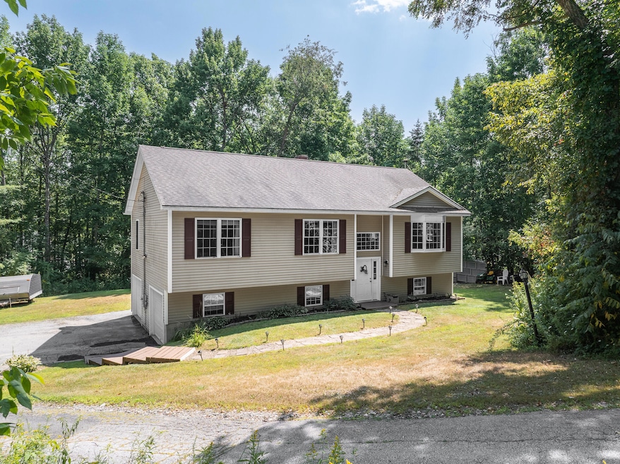


Just minutes from beautiful Pushaw Lake, this 3-bedroom, 2.5-bath home blends modern style with everyday comfort. Step inside to find fresh updates, a sleek kitchen with stainless steel appliances and tile backsplash and a spacious family room anchored by a cozy pellet stove. The generous yard is perfect for play, gardening, or simply relaxing, and the 2-car garage offers plenty of storage. Located in a sought-after school choice town, this property delivers the perfect mix of location, lifestyle, and value!
Last Agent to Sell the Property
NextHome Experience Listed on: 08/15/2025
| Date | Type | Sale Price | Title Company |
|---|---|---|---|
| Warranty Deed | $429,900 | -- | |
| Warranty Deed | $429,900 | -- | |
| Warranty Deed | -- | -- |
| Date | Status | Loan Amount | Loan Type |
|---|---|---|---|
| Open | $386,910 | New Conventional | |
| Closed | $386,910 | New Conventional | |
| Previous Owner | $203,930 | FHA | |
| Previous Owner | $197,500 | Purchase Money Mortgage |
| Date | Event | Price | List to Sale | Price per Sq Ft |
|---|---|---|---|---|
| 09/17/2025 09/17/25 | Sold | $429,900 | +2.4% | $225 / Sq Ft |
| 08/17/2025 08/17/25 | Pending | -- | -- | -- |
| 08/15/2025 08/15/25 | For Sale | $419,900 | -- | $219 / Sq Ft |
| Year | Tax Paid | Tax Assessment Tax Assessment Total Assessment is a certain percentage of the fair market value that is determined by local assessors to be the total taxable value of land and additions on the property. | Land | Improvement |
|---|---|---|---|---|
| 2024 | $2,968 | $215,060 | $42,140 | $172,920 |
| 2023 | $2,989 | $215,060 | $42,140 | $172,920 |
| 2022 | $3,006 | $179,440 | $35,120 | $144,320 |
| 2021 | $3,230 | $179,440 | $35,120 | $144,320 |
| 2020 | $3,266 | $179,440 | $35,120 | $144,320 |
| 2019 | $3,275 | $179,440 | $35,120 | $144,320 |
| 2018 | $3,320 | $179,440 | $35,120 | $144,320 |
| 2017 | $4,132 | $194,910 | $22,210 | $172,700 |
| 2016 | $3,937 | $194,900 | $22,200 | $172,700 |
| 2015 | $3,830 | $194,900 | $22,200 | $172,700 |
| 2014 | $3,625 | $194,900 | $22,200 | $172,700 |
| 2012 | $3,788 | $197,800 | $25,100 | $172,700 |
Seller's Agent in 2025
Lewis Morrison Nicole Drake
NextHome Experience
(207) 343-0143
14 in this area
384 Total Sales
A
Buyer's Agent in 2025
Addie Peet
Portside Real Estate Group
(207) 991-3799
1 in this area
104 Total Sales
Buyer Co-Listing Agent in 2025
Brent Sawyer
Portside Real Estate Group
(207) 756-5135
1 in this area
391 Total Sales
Source: Maine Listings
MLS Number: 1634362
APN: GLBN-000025-000000-000123-000002
Disclaimer: Certain information contained herein is derived from information provided by parties other than Homes.com. All information provided is deemed reliable, but is not guaranteed to be accurate and should be independently verified.
![]() Listing data is derived in whole or in part from Maine Real Estate Information System, Inc. (d/b/a Maine Listings) and is for consumers' personal, noncommercial use only. Dimensions are approximate and not guaranteed. All data should be independently verified.
Listing data is derived in whole or in part from Maine Real Estate Information System, Inc. (d/b/a Maine Listings) and is for consumers' personal, noncommercial use only. Dimensions are approximate and not guaranteed. All data should be independently verified.
© 2025 Maine Real Estate Information System, Inc. All Rights Reserved. Equal Housing Opportunity.
Homes.com, LLC, 17600 Laguna Canyon Rd Irvine, CA 92618 (888)-952-6393
![]()