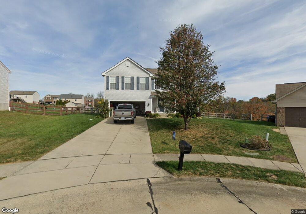
1346 Brisbane Rd Independence, KY 41051
Estimated Value: $373,346 - $383,000
4
Beds
3
Baths
2,072
Sq Ft
$183/Sq Ft
Est. Value
About This Home
This home is located at 1346 Brisbane Rd, Independence, KY 41051 and is currently estimated at $378,587, approximately $182 per square foot. 1346 Brisbane Rd is a home located in Kenton County with nearby schools including Simon Kenton High School and St. Cecilia Catholic School.
Ownership History
Date
Name
Owned For
Owner Type
Purchase Details
Closed on
Mar 30, 2020
Sold by
Hill Mary Clare and Hill Frank Claude
Bought by
Fennell Kenneth L and Fennell Mary E
Current Estimated Value
Purchase Details
Closed on
Mar 16, 2020
Sold by
Mueller Laura and Hasenkamp Savanna Marie
Bought by
Hill Mary Clare
Purchase Details
Closed on
Oct 27, 2006
Sold by
The Drees Co
Bought by
Hasenkamp John G
Home Financials for this Owner
Home Financials are based on the most recent Mortgage that was taken out on this home.
Original Mortgage
$223,003
Interest Rate
6.27%
Mortgage Type
FHA
Purchase Details
Closed on
Jul 12, 2006
Sold by
Independence Station Road Llc
Bought by
The Drees Co
Create a Home Valuation Report for This Property
The Home Valuation Report is an in-depth analysis detailing your home's value as well as a comparison with similar homes in the area
Home Values in the Area
Average Home Value in this Area
Purchase History
| Date | Buyer | Sale Price | Title Company |
|---|---|---|---|
| Fennell Kenneth L | $252,000 | Homestead Title Agency Ltd | |
| Hill Mary Clare | $1,125,000 | None Available | |
| Hasenkamp John G | $224,782 | Dba Bluegrass Title Company | |
| The Drees Co | $85,000 | Kentucky Land Title Agency I |
Source: Public Records
Mortgage History
| Date | Status | Borrower | Loan Amount |
|---|---|---|---|
| Previous Owner | Hasenkamp John G | $223,003 |
Source: Public Records
Tax History
| Year | Tax Paid | Tax Assessment Tax Assessment Total Assessment is a certain percentage of the fair market value that is determined by local assessors to be the total taxable value of land and additions on the property. | Land | Improvement |
|---|---|---|---|---|
| 2025 | $3,348 | $287,900 | $50,000 | $237,900 |
| 2024 | $3,087 | $252,000 | $35,000 | $217,000 |
| 2023 | $3,180 | $252,000 | $35,000 | $217,000 |
| 2022 | $3,236 | $252,000 | $35,000 | $217,000 |
| 2021 | $3,284 | $252,000 | $35,000 | $217,000 |
| 2020 | $2,998 | $224,700 | $26,000 | $198,700 |
| 2019 | $3,006 | $224,700 | $26,000 | $198,700 |
| 2018 | $3,023 | $224,700 | $26,000 | $198,700 |
| 2017 | $2,940 | $224,700 | $26,000 | $198,700 |
| 2015 | $2,858 | $224,700 | $43,000 | $181,700 |
| 2014 | $2,818 | $224,700 | $43,000 | $181,700 |
Source: Public Records
Map
Nearby Homes
- 1365 Cairns Ct
- 9964 Meadow Glen Dr
- 9980 Meadow Glen Dr
- 9971 Meadow Glen Dr
- 5220 Cody Rd
- 10008 Meadow Glen Dr
- 1884 Bridle Path
- 4828 Far Hills Dr
- 2037 Patriot Way
- 1381 Poplartree Place
- 10362 Petersburg Ct
- 10213 Highmeadow Ln
- 1247 Monocacy Ct
- 6500 Julia Meadow
- 1197 Catletts Ct
- 4758 Fowler Creek Rd
- 3981 Sherbourne Dr
- 3828 Sherbourne Dr
- 1217 Cannonball Way
- 1468 Shirepeak Way
Your Personal Tour Guide
Ask me questions while you tour the home.