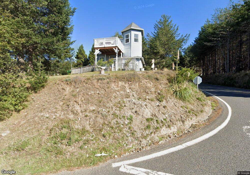
1346 Upper Pacific Dr Whitethorn, CA 95589
Estimated Value: $417,553 - $474,000
3
Beds
3
Baths
1,470
Sq Ft
$309/Sq Ft
Est. Value
About This Home
This home is located at 1346 Upper Pacific Dr, Whitethorn, CA 95589 and is currently estimated at $453,888, approximately $308 per square foot. 1346 Upper Pacific Dr is a home located in Humboldt County.
Ownership History
Date
Name
Owned For
Owner Type
Purchase Details
Closed on
Jun 20, 2019
Sold by
Hamilton Virginia A and Hamilton Alfred L
Bought by
Soluri Michael T and Rose Colleen A
Current Estimated Value
Home Financials for this Owner
Home Financials are based on the most recent Mortgage that was taken out on this home.
Original Mortgage
$333,841
Outstanding Balance
$292,918
Interest Rate
4.1%
Mortgage Type
New Conventional
Estimated Equity
$160,970
Purchase Details
Closed on
Jul 23, 2009
Sold by
Hamilton Virginia A Durland
Bought by
Hamilton Virginia A and Hamilton Alfred L
Home Financials for this Owner
Home Financials are based on the most recent Mortgage that was taken out on this home.
Original Mortgage
$304,800
Interest Rate
5.31%
Mortgage Type
New Conventional
Purchase Details
Closed on
Jun 19, 2008
Sold by
Hamilton A L and Hamilton Virginia Durland
Bought by
Li Hamilton Virginia A Durland
Home Financials for this Owner
Home Financials are based on the most recent Mortgage that was taken out on this home.
Original Mortgage
$300,000
Interest Rate
5.87%
Mortgage Type
New Conventional
Purchase Details
Closed on
May 22, 2008
Sold by
Li Hamilton Virginia A Durland
Bought by
Hamilton Virginia A and Hamilton Alfred L
Home Financials for this Owner
Home Financials are based on the most recent Mortgage that was taken out on this home.
Original Mortgage
$300,000
Interest Rate
5.87%
Mortgage Type
New Conventional
Purchase Details
Closed on
Feb 1, 2005
Sold by
Hamilton A L and Hamilton Virginia Durland
Bought by
Li Hamilton Virginia A Durland
Purchase Details
Closed on
Apr 15, 2003
Sold by
Reed Patricia Christine and Moore Patricia C
Bought by
Hamilton A L and Hamilton Virginia Durland
Purchase Details
Closed on
Sep 7, 2000
Sold by
Hadley Lindy Lou
Bought by
Traverso Doug and Traverso Sybil
Create a Home Valuation Report for This Property
The Home Valuation Report is an in-depth analysis detailing your home's value as well as a comparison with similar homes in the area
Home Values in the Area
Average Home Value in this Area
Purchase History
| Date | Buyer | Sale Price | Title Company |
|---|---|---|---|
| Soluri Michael T | $340,000 | Humboldt Land Title | |
| Hamilton Virginia A | -- | Inter County Title Co Of El | |
| Li Hamilton Virginia A Durland | -- | None Available | |
| Hamilton Virginia A | -- | Inter County Title Co | |
| Li Hamilton Virginia A Durland | -- | None Available | |
| Hamilton A L | $37,500 | Fidelity National | |
| Traverso Doug | $40,000 | First American Title Co |
Source: Public Records
Mortgage History
| Date | Status | Borrower | Loan Amount |
|---|---|---|---|
| Open | Soluri Michael T | $333,841 | |
| Previous Owner | Hamilton Virginia A | $304,800 | |
| Previous Owner | Hamilton Virginia A | $300,000 |
Source: Public Records
Tax History
| Year | Tax Paid | Tax Assessment Tax Assessment Total Assessment is a certain percentage of the fair market value that is determined by local assessors to be the total taxable value of land and additions on the property. | Land | Improvement |
|---|---|---|---|---|
| 2025 | $4,234 | $379,272 | $111,550 | $267,722 |
| 2024 | $4,234 | $371,836 | $109,363 | $262,473 |
| 2023 | $4,249 | $364,546 | $107,219 | $257,327 |
| 2022 | $4,184 | $357,399 | $105,117 | $252,282 |
| 2021 | $4,032 | $350,392 | $103,056 | $247,336 |
| 2020 | $4,054 | $346,800 | $102,000 | $244,800 |
| 2019 | $4,254 | $360,365 | $48,680 | $311,685 |
| 2018 | $4,185 | $353,300 | $47,726 | $305,574 |
| 2017 | $4,009 | $346,374 | $46,791 | $299,583 |
| 2016 | $3,986 | $339,583 | $45,874 | $293,709 |
| 2015 | $3,966 | $334,483 | $45,185 | $289,298 |
| 2014 | $3,795 | $327,932 | $44,300 | $283,632 |
Source: Public Records
Map
Nearby Homes
- 16 Bambi Dr
- 36 Bambi Dr
- 1325&1335 Upper Pacific Dr
- 82 Fawn Dr
- 112 Seafoam Rd
- 90 Fawn Dr
- 22 Spruce Ct
- 60 Spruce Rd
- 155 Seafoam Rd
- 190 Shaker Rd
- 8 Buckhorn Ct
- 5 Antler Ct
- 156 Shaker Rd
- 27 Buckhorn Ct
- 75 Neptune Rd
- 126 Neptune Dr
- 680 Lower Pacific Dr
- 142 Oceanview Rd
- 454 Lower Pacific Dr
- 806 Lower Pacific Dr
- 9487 Shelter Cove Rd
- 1345 Upper Pacific Dr
- 1320 Upper Pacific Dr
- 1390 Upper Pacific Dr
- 16 Bambi Ct
- 1397 Upper Pacific Dr
- 1312 Upper Pacific Dr
- 1312 -1330 Upper Pacific Dr
- 16 Bambi Rd
- 19 Bambi Dr
- 1390 Upper Pacific Dr
- 1390 Upper Pacific Dr
- 1375 Upper Pacific Dr
- 1387 Upper Pacific Dr
- 1330 Upper Pacific Dr
- 6 Fawn Dr
- 46 Bambi Dr
- 16 Fawn Dr
- 1412 1422 Upper Pacific Dr
- 1284 Upper Pacific Dr
Your Personal Tour Guide
Ask me questions while you tour the home.