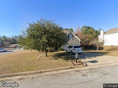
1347 Freedom Ridge Dr Columbus, GA 31907
Estimated Value: $275,000 - $302,000
4
Beds
3
Baths
2,640
Sq Ft
$109/Sq Ft
Est. Value
About This Home
This home is located at 1347 Freedom Ridge Dr, Columbus, GA 31907 and is currently estimated at $287,703, approximately $108 per square foot. 1347 Freedom Ridge Dr is a home located in Muscogee County with nearby schools including Dawson Elementary School, East Columbus Magnet Academy, and Spencer High School.
Ownership History
Date
Name
Owned For
Owner Type
Purchase Details
Closed on
Nov 25, 2015
Sold by
Bond Brent
Bought by
Brooks Eddie
Current Estimated Value
Home Financials for this Owner
Home Financials are based on the most recent Mortgage that was taken out on this home.
Original Mortgage
$177,000
Interest Rate
3.83%
Mortgage Type
VA
Purchase Details
Closed on
Dec 14, 2010
Sold by
Grayhawk Homes Inc
Bought by
Bond Brent Mckenna
Home Financials for this Owner
Home Financials are based on the most recent Mortgage that was taken out on this home.
Original Mortgage
$150,624
Interest Rate
4.32%
Mortgage Type
VA
Create a Home Valuation Report for This Property
The Home Valuation Report is an in-depth analysis detailing your home's value as well as a comparison with similar homes in the area
Home Values in the Area
Average Home Value in this Area
Purchase History
| Date | Buyer | Sale Price | Title Company |
|---|---|---|---|
| Brooks Eddie | $177,000 | -- | |
| Bond Brent Mckenna | $173,800 | None Available | |
| Brent Mckenna Bond Grayhawk Homes Inc | -- | None Available |
Source: Public Records
Mortgage History
| Date | Status | Borrower | Loan Amount |
|---|---|---|---|
| Open | Brooks Eddie | $6,418 | |
| Open | Brooks Eddie | $177,926 | |
| Closed | Brooks Eddie | $177,000 | |
| Previous Owner | Bond Brent Mckenna | $150,624 |
Source: Public Records
Tax History Compared to Growth
Tax History
| Year | Tax Paid | Tax Assessment Tax Assessment Total Assessment is a certain percentage of the fair market value that is determined by local assessors to be the total taxable value of land and additions on the property. | Land | Improvement |
|---|---|---|---|---|
| 2024 | -- | $108,488 | $12,788 | $95,700 |
| 2023 | $0 | $108,488 | $12,788 | $95,700 |
| 2022 | $0 | $79,980 | $12,788 | $67,192 |
| 2021 | $0 | $70,296 | $12,788 | $57,508 |
| 2020 | $0 | $70,296 | $12,788 | $57,508 |
| 2019 | $36 | $70,296 | $12,788 | $57,508 |
| 2018 | $0 | $70,296 | $12,788 | $57,508 |
| 2017 | $1,756 | $70,316 | $12,788 | $57,528 |
| 2016 | $91 | $69,407 | $13,600 | $55,807 |
| 2015 | $2,867 | $69,407 | $13,600 | $55,807 |
| 2014 | $2,870 | $69,407 | $13,600 | $55,807 |
| 2013 | -- | $69,407 | $13,600 | $55,807 |
Source: Public Records
Map
Nearby Homes
- 1318 Freedom Ridge Dr
- 1300 Freedom Ridge Dr
- 5108 Lexington Ln
- 1340 Bunker Ridge Ln
- 5140 Magazine Ln
- 5300 Stoney Point Rd
- 1397 Kings Mountain Rd
- 1415 Antietam Dr
- 1866 Bunker Hill Rd
- 1235 Belmar St
- 1513 Alamo Dr
- 5644 Quebec Dr
- 5700 Germantown Rd
- 4462 Walking Stick Way
- 4447 Walking Stick Way
- 4939 Aaron Dr
- 4804 Toney Dr
- 5022 Aaron Ln
- 780 Honey Do Ct
- 1035 Bedford Ave
- 1347 Freedom Ridge Dr
- 1341 Freedom Ridge Dr
- 5192 Freedom Ridge Ct
- 1335 Freedom Ridge Dr
- 5185 Freedom Ridge Ct
- 1348 Freedom Ridge Dr
- 1342 Freedom Ridge Dr
- 5188 Freedom Ridge Ct
- 1352 Freedom Ridge Dr
- 5177 Freedom Ridge Ct
- 1358 Freedom Ridge Dr
- 5176 Sand Hill Dr
- 5194 Sand Hill Dr
- 1330 Freedom Ridge Dr
- 1362 Freedom Ridge Dr
- 1359 Freedom Ridge Dr
- 5172 Sand Hill Dr
- 1324 Freedom Ridge Dr
- 5168 Sand Hill Dr
- 1305 Bunker Ridge Ln