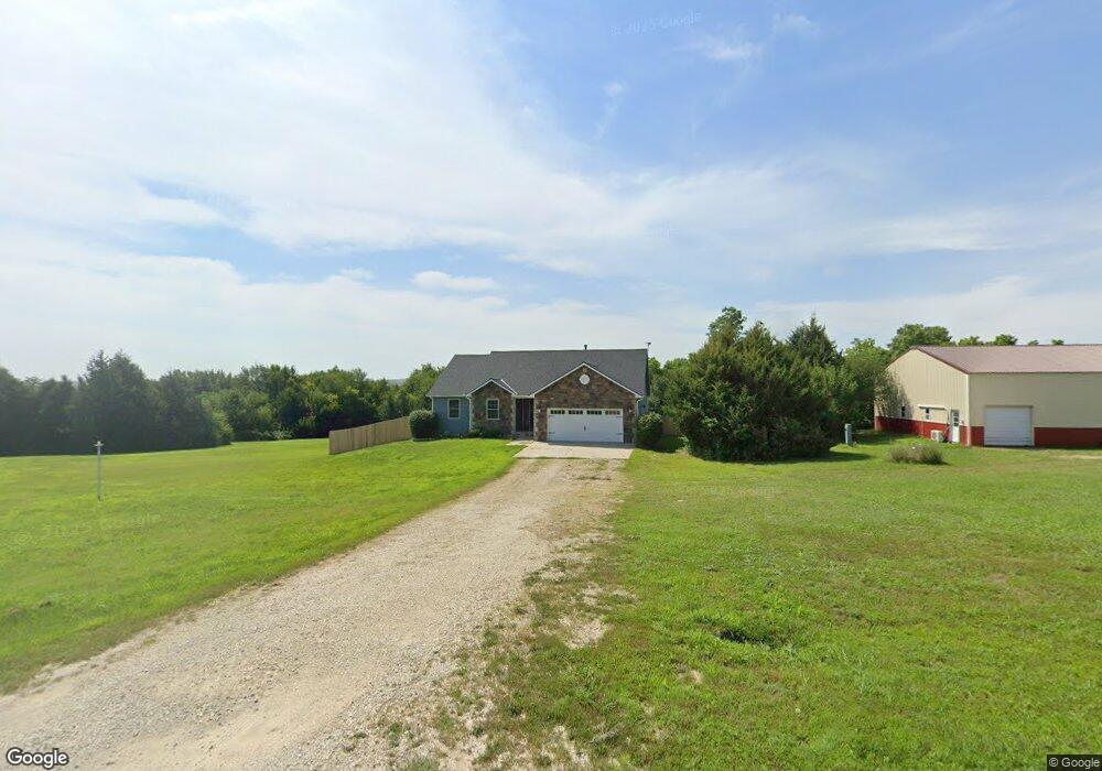
13485 Curtis Cir Wamego, KS 66547
Estimated Value: $439,000 - $546,912
4
Beds
3
Baths
3,196
Sq Ft
$152/Sq Ft
Est. Value
About This Home
This home is located at 13485 Curtis Cir, Wamego, KS 66547 and is currently estimated at $484,228, approximately $151 per square foot. 13485 Curtis Cir is a home located in Pottawatomie County with nearby schools including Rock Creek Junior/Senior High School.
Ownership History
Date
Name
Owned For
Owner Type
Purchase Details
Closed on
Jan 26, 2023
Sold by
Herrick Frederick D
Bought by
Traudt Matthew and Traudt Kira
Current Estimated Value
Home Financials for this Owner
Home Financials are based on the most recent Mortgage that was taken out on this home.
Original Mortgage
$360,000
Interest Rate
6.09%
Mortgage Type
New Conventional
Purchase Details
Closed on
Dec 19, 2011
Sold by
Gaskill Stephanie A
Bought by
Herriek Frederick D and Herriek Mary C
Create a Home Valuation Report for This Property
The Home Valuation Report is an in-depth analysis detailing your home's value as well as a comparison with similar homes in the area
Home Values in the Area
Average Home Value in this Area
Purchase History
| Date | Buyer | Sale Price | Title Company |
|---|---|---|---|
| Traudt Matthew | -- | Heartland Title | |
| Herriek Frederick D | -- | None Available |
Source: Public Records
Mortgage History
| Date | Status | Borrower | Loan Amount |
|---|---|---|---|
| Previous Owner | Traudt Matthew | $360,000 |
Source: Public Records
Tax History Compared to Growth
Tax History
| Year | Tax Paid | Tax Assessment Tax Assessment Total Assessment is a certain percentage of the fair market value that is determined by local assessors to be the total taxable value of land and additions on the property. | Land | Improvement |
|---|---|---|---|---|
| 2025 | $5,165 | $55,396 | $5,106 | $50,290 |
| 2024 | $52 | $52,900 | $4,914 | $47,986 |
| 2023 | $4,191 | $41,515 | $4,953 | $36,562 |
| 2022 | $3,389 | $36,202 | $4,808 | $31,394 |
| 2021 | $3,389 | $33,553 | $4,463 | $29,090 |
| 2020 | $3,389 | $33,353 | $4,463 | $28,890 |
| 2019 | $3,471 | $33,719 | $4,463 | $29,256 |
| 2018 | $3,570 | $33,686 | $4,494 | $29,192 |
| 2017 | $3,130 | $33,314 | $4,494 | $28,820 |
| 2016 | $3,040 | $33,456 | $4,322 | $29,134 |
| 2015 | -- | $32,896 | $4,281 | $28,615 |
| 2014 | -- | $31,989 | $4,188 | $27,801 |
Source: Public Records
Map
Nearby Homes
- 13000 Anthony Dr
- 4225 Rockenham Rd
- 14362 Prairie W
- 14344 Prairie W
- 00000 Prairie Trail (Lot #3)
- 00000 Wildwood Cir
- 14226 Prairie W
- 00000 Prairie Trail
- 4075 Rockenham Cir
- 14205 Prairie Trail
- 14409 Wildwood Cir
- 14416 Wildwood Cir
- 14391 Prairie Trail
- 14380 Prairie Trail
- 14373 Prairie Trail
- 13318 Woodland Dr
- 14434 Wildwood Cir
- 14470 Wildwood Cir
- 13880 Berry Ln
- 14578 Wildwood Cir
- 13520 Curtis Cir
- 13450 Curtis Cir
- 13477 Curtis Cir
- 13555 Curtis Cir
- 13525 Wildridge Dr
- 13525 Wildridge Dr
- 13495 Wildridge Rd
- 13575 Wildridge Rd
- 13580 Vineyard Cir
- 5454 Vineyard Rd
- 13575 Wildridge Dr
- 13532 Vineyard Cir
- 13445 Wildridge Rd
- 13520 Wildridge Rd
- 13482 Wildridge Rd
- 13460 Wildridge Rd
- 13508 Vineyard Rd
- 13570 Wildridge Dr
- 13570 Wildridge Dr
- 13395 Wildridge Dr