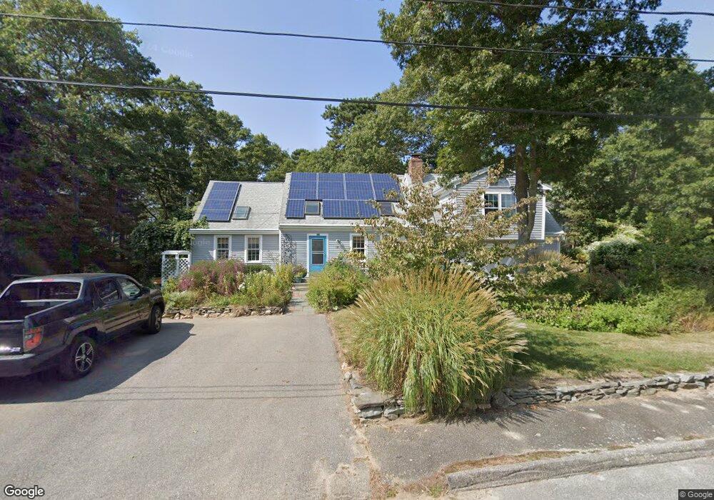
135 Captain Ellis Ln Hyannis, MA 02601
Centerville NeighborhoodEstimated Value: $667,000 - $797,000
3
Beds
3
Baths
2,106
Sq Ft
$337/Sq Ft
Est. Value
About This Home
This home is located at 135 Captain Ellis Ln, Hyannis, MA 02601 and is currently estimated at $710,496, approximately $337 per square foot. 135 Captain Ellis Ln is a home located in Barnstable County with nearby schools including Barnstable United Elementary School, West Barnstable Elementary School, and Barnstable Intermediate School.
Ownership History
Date
Name
Owned For
Owner Type
Purchase Details
Closed on
Oct 18, 2018
Sold by
Murphy-Finn Kathleen and Pillsbury Kathleen
Bought by
Captain Ellis Rt
Current Estimated Value
Purchase Details
Closed on
Feb 18, 1992
Sold by
Atkins Patricia
Bought by
Pillsbury Kathleen
Home Financials for this Owner
Home Financials are based on the most recent Mortgage that was taken out on this home.
Original Mortgage
$40,000
Interest Rate
8.18%
Mortgage Type
Purchase Money Mortgage
Create a Home Valuation Report for This Property
The Home Valuation Report is an in-depth analysis detailing your home's value as well as a comparison with similar homes in the area
Home Values in the Area
Average Home Value in this Area
Purchase History
| Date | Buyer | Sale Price | Title Company |
|---|---|---|---|
| Captain Ellis Rt | -- | -- | |
| Pillsbury Kathleen | $79,000 | -- |
Source: Public Records
Mortgage History
| Date | Status | Borrower | Loan Amount |
|---|---|---|---|
| Previous Owner | Pillsbury Kathleen | $40,000 | |
| Previous Owner | Pillsbury Kathleen | $75,000 |
Source: Public Records
Tax History Compared to Growth
Tax History
| Year | Tax Paid | Tax Assessment Tax Assessment Total Assessment is a certain percentage of the fair market value that is determined by local assessors to be the total taxable value of land and additions on the property. | Land | Improvement |
|---|---|---|---|---|
| 2025 | $6,325 | $682,300 | $152,200 | $530,100 |
| 2024 | $5,868 | $648,400 | $152,200 | $496,200 |
| 2023 | $5,540 | $578,900 | $138,400 | $440,500 |
| 2022 | $5,521 | $477,200 | $102,500 | $374,700 |
| 2021 | $5,078 | $426,400 | $102,500 | $323,900 |
| 2020 | $4,904 | $397,700 | $102,500 | $295,200 |
| 2019 | $4,598 | $365,500 | $102,500 | $263,000 |
| 2018 | $4,150 | $337,400 | $107,900 | $229,500 |
| 2017 | $3,909 | $326,000 | $107,900 | $218,100 |
| 2016 | $3,940 | $335,900 | $108,700 | $227,200 |
| 2015 | $3,481 | $300,900 | $105,400 | $195,500 |
Source: Public Records
Map
Nearby Homes
- 82 Nobadeer Rd
- 140 Wequaquet Ln
- 270 Old Strawberry Hill Rd
- 21 Brian Ln
- 78 Brant Way
- 58 Loomis Ln
- 2 Longview Dr
- 15 Square Rigger Ln
- 25 Daybreak Ln
- 296 Lincoln Rd
- 75 Olander Dr
- 75 Olander Dr
- 86 Arrowhead Dr
- 825 W Main St Unit 4
- 576 Strawberry Hill Rd
- 720 Pitchers Way Unit 52
- 68 Seaboard Ln
- 43 Statice Ln
- 241 Longview Dr
- 7 Christinas Path
- 130 Captain Ellis Ln
- 7 Christina's
- 231 Longview Dr
- 260 Longview Dr
- 142 Captain Ellis Ln
- 124 Nobadeer Rd
- 117 Captain Ellis Ln
- 112 Nobadeer Rd
- 132 Nobadeer Rd
- 18 Christina's Path
- 118 Captain Ellis Ln
- 250 Longview Dr
- 21 Jennies Path
- 221 Longview Dr
- 18 Christinas Path
- 7 Christinas Path
- 23 Jennies Path
- 220 Longview Dr