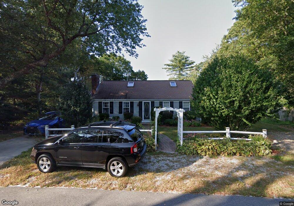
135 Highland Dr Centerville, MA 02632
Centerville NeighborhoodEstimated Value: $531,000 - $559,000
3
Beds
1
Bath
1,273
Sq Ft
$429/Sq Ft
Est. Value
About This Home
This home is located at 135 Highland Dr, Centerville, MA 02632 and is currently estimated at $546,574, approximately $429 per square foot. 135 Highland Dr is a home located in Barnstable County with nearby schools including Centerville Elementary School, Barnstable United Elementary School, and Barnstable Intermediate School.
Ownership History
Date
Name
Owned For
Owner Type
Purchase Details
Closed on
Jun 30, 2021
Sold by
Noonan David F and Noonan Mary J
Bought by
Noonan Margaret
Current Estimated Value
Home Financials for this Owner
Home Financials are based on the most recent Mortgage that was taken out on this home.
Original Mortgage
$320,000
Outstanding Balance
$290,350
Interest Rate
2.9%
Mortgage Type
Purchase Money Mortgage
Estimated Equity
$256,224
Create a Home Valuation Report for This Property
The Home Valuation Report is an in-depth analysis detailing your home's value as well as a comparison with similar homes in the area
Home Values in the Area
Average Home Value in this Area
Purchase History
| Date | Buyer | Sale Price | Title Company |
|---|---|---|---|
| Noonan Margaret | $400,000 | None Available |
Source: Public Records
Mortgage History
| Date | Status | Borrower | Loan Amount |
|---|---|---|---|
| Open | Noonan Margaret | $320,000 |
Source: Public Records
Tax History Compared to Growth
Tax History
| Year | Tax Paid | Tax Assessment Tax Assessment Total Assessment is a certain percentage of the fair market value that is determined by local assessors to be the total taxable value of land and additions on the property. | Land | Improvement |
|---|---|---|---|---|
| 2025 | $3,827 | $473,100 | $151,900 | $321,200 |
| 2024 | $3,569 | $457,000 | $151,900 | $305,100 |
| 2023 | $3,419 | $409,900 | $138,100 | $271,800 |
| 2022 | $3,231 | $335,200 | $102,300 | $232,900 |
| 2021 | $3,200 | $305,100 | $102,300 | $202,800 |
| 2020 | $3,161 | $288,400 | $102,300 | $186,100 |
| 2019 | $3,032 | $268,800 | $102,300 | $166,500 |
| 2018 | $2,813 | $250,700 | $107,700 | $143,000 |
| 2017 | $2,630 | $244,400 | $107,700 | $136,700 |
| 2016 | $2,673 | $245,200 | $108,500 | $136,700 |
| 2015 | $2,644 | $243,700 | $105,100 | $138,600 |
Source: Public Records
Map
Nearby Homes
- 81 Monomoy Cir
- 296 Buckskin Path
- 149 Old Stage Rd
- 16 Bridgets Path
- 53 Meadow Farm Rd
- 52 Meadow Farm Rd
- 205 James Otis Rd
- 315 Prince Hinckley Rd
- 21 Shannon Way
- 40 Sachem Dr
- 900 Old Stage Rd
- 73 Tern Ln
- 66 Tern Ln
- 156 S Main St
- 62 Three Ponds Dr
- 87 Foxglove Rd
- 58 Loomis Ln
- 290 Riverview Ln
- 50 Pheasant Way Unit A&B
- 50 Pheasant Way
- 127 Highland Dr
- 145 Highland Dr
- 457 Old Stage Rd
- 40 Bayberry Ln
- 505 Old Stage Rd
- 130 Highland Dr
- 121 Highland Dr
- 146 Highland Dr
- 30 Bayberry Ln
- 113 Highland Dr
- 465 Old Stage Rd
- 158 Highland Dr
- 100 Highland Dr
- 163 Highland Dr
- 463 Old Stage Rd
- 22 Bayberry Ln
- 507 Old Stage Rd
- 82 Highland Dr
- 21 Bayberry Ln
- 168 Highland Dr