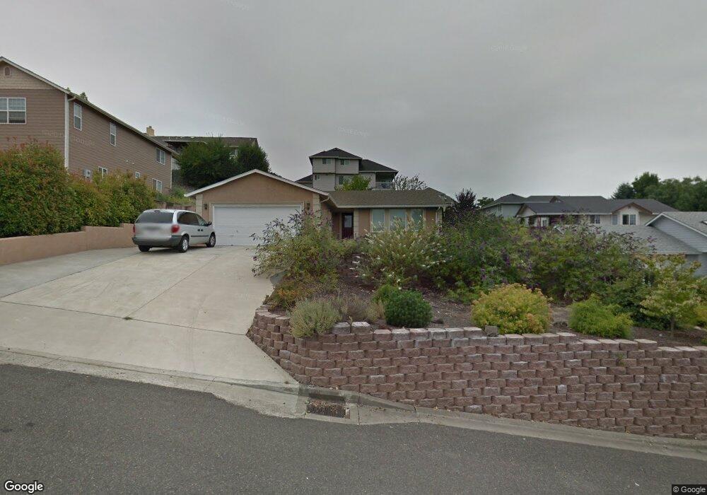
135 Jamie Loop Roseburg, OR 97471
Green NeighborhoodEstimated Value: $411,000 - $431,000
3
Beds
2
Baths
1,704
Sq Ft
$245/Sq Ft
Est. Value
About This Home
This home is located at 135 Jamie Loop, Roseburg, OR 97471 and is currently estimated at $417,518, approximately $245 per square foot. 135 Jamie Loop is a home located in Douglas County with nearby schools including Green Elementary School, John C. Fremont Middle School, and Roseburg High School.
Ownership History
Date
Name
Owned For
Owner Type
Purchase Details
Closed on
May 31, 2017
Sold by
Wilson Rodney V and Wilson Terri A
Bought by
Maxwell Thomas L and Maxwell Jaylene R
Current Estimated Value
Home Financials for this Owner
Home Financials are based on the most recent Mortgage that was taken out on this home.
Original Mortgage
$198,550
Outstanding Balance
$164,127
Interest Rate
3.97%
Mortgage Type
New Conventional
Estimated Equity
$253,391
Purchase Details
Closed on
Jan 15, 2014
Sold by
Wilson Rodney V
Bought by
Wilson Rodney and Wilson Terri A
Home Financials for this Owner
Home Financials are based on the most recent Mortgage that was taken out on this home.
Original Mortgage
$153,000
Interest Rate
4.46%
Mortgage Type
New Conventional
Purchase Details
Closed on
Jan 14, 2014
Sold by
Atkeson Toby S
Bought by
Wilson Rodney
Home Financials for this Owner
Home Financials are based on the most recent Mortgage that was taken out on this home.
Original Mortgage
$153,000
Interest Rate
4.46%
Mortgage Type
New Conventional
Purchase Details
Closed on
Sep 19, 2008
Sold by
Perry Anthony F and Perry Margaret
Bought by
Wilson Rodney and Atkeson Toby S
Home Financials for this Owner
Home Financials are based on the most recent Mortgage that was taken out on this home.
Original Mortgage
$156,000
Interest Rate
6.51%
Mortgage Type
Purchase Money Mortgage
Purchase Details
Closed on
Mar 7, 2007
Sold by
Greer Robert and Greer Sheila
Bought by
Perry Anthony F and Perry Margaret
Home Financials for this Owner
Home Financials are based on the most recent Mortgage that was taken out on this home.
Original Mortgage
$156,000
Interest Rate
6.23%
Mortgage Type
Purchase Money Mortgage
Purchase Details
Closed on
Apr 22, 2005
Sold by
Songer Steve
Bought by
Greer Robert and Greer Sheila
Home Financials for this Owner
Home Financials are based on the most recent Mortgage that was taken out on this home.
Original Mortgage
$180,000
Interest Rate
5.84%
Mortgage Type
Purchase Money Mortgage
Create a Home Valuation Report for This Property
The Home Valuation Report is an in-depth analysis detailing your home's value as well as a comparison with similar homes in the area
Home Values in the Area
Average Home Value in this Area
Purchase History
| Date | Buyer | Sale Price | Title Company |
|---|---|---|---|
| Maxwell Thomas L | $209,000 | First American Title | |
| Wilson Rodney | -- | Evergreen Land Title Company | |
| Wilson Rodney | -- | Evergreen Land Title Company | |
| Wilson Rodney | -- | Evergreen Land Title Company | |
| Wilson Rodney | $195,000 | Amerititle | |
| Perry Anthony F | $206,000 | Amerititle | |
| Greer Robert | $48,000 | Ticor Title |
Source: Public Records
Mortgage History
| Date | Status | Borrower | Loan Amount |
|---|---|---|---|
| Open | Maxwell Thomas L | $198,550 | |
| Previous Owner | Wilson Rodney | $153,000 | |
| Previous Owner | Wilson Rodney | $156,000 | |
| Previous Owner | Perry Anthony F | $156,000 | |
| Previous Owner | Greer Robert | $180,000 |
Source: Public Records
Tax History Compared to Growth
Tax History
| Year | Tax Paid | Tax Assessment Tax Assessment Total Assessment is a certain percentage of the fair market value that is determined by local assessors to be the total taxable value of land and additions on the property. | Land | Improvement |
|---|---|---|---|---|
| 2025 | $2,186 | $233,640 | -- | -- |
| 2024 | $2,122 | $226,835 | -- | -- |
| 2023 | $2,060 | $220,229 | $0 | $0 |
| 2022 | $2,000 | $213,815 | $0 | $0 |
| 2021 | $1,942 | $207,588 | $0 | $0 |
| 2020 | $1,961 | $201,542 | $0 | $0 |
| 2019 | $1,925 | $195,672 | $0 | $0 |
| 2018 | $1,880 | $189,973 | $0 | $0 |
| 2017 | $1,824 | $184,440 | $0 | $0 |
| 2016 | $1,792 | $179,068 | $0 | $0 |
| 2015 | $1,762 | $173,853 | $0 | $0 |
| 2014 | $1,707 | $168,790 | $0 | $0 |
| 2013 | -- | $163,874 | $0 | $0 |
Source: Public Records
Map
Nearby Homes
- 135 SW Quincetree Ct
- 144 Peppertree Ct
- 4467 Melody Ln
- 200 Emils Way Unit 20
- 200 Emils Way Unit 21
- 1880 Linnell Ave
- 132 Aspen Ct
- 4913 Melody Ln
- 4885 SW Grange Rd
- 4807 SW Grange Rd
- 180 Brady Ln
- 258 Bobwhite St
- 10 Carmel Ct
- 189 Quincy Ave
- 5135 Grange Rd
- 633 Highland Vista Ln
- 104 Angelcrest Ct
- 135 Othello Ave
- 807 Callahan Dr
- 4072 Hanna St
- 151 Jamie Loop
- 140 Jamie Loop
- 125 Jamie Loop
- 317 Jamie Loop
- 305 Jamie Loop
- 398 Chandler Dr
- 440 Chandler Dr
- 167 Jamie Loop
- 287 Jamie Loop
- 160 Jamie Loop
- 211 Jamie Loop Unit Rd
- 211 Jamie Loop
- 135 Quincetree Ct
- 227 Jamie Loop
- 123 Quincetree Ct
- 0 Jamie Loop
- 256 Jamie Loop
- 248 Jamie Loop
- 176 Jamie Loop
- 409 Chandler Dr