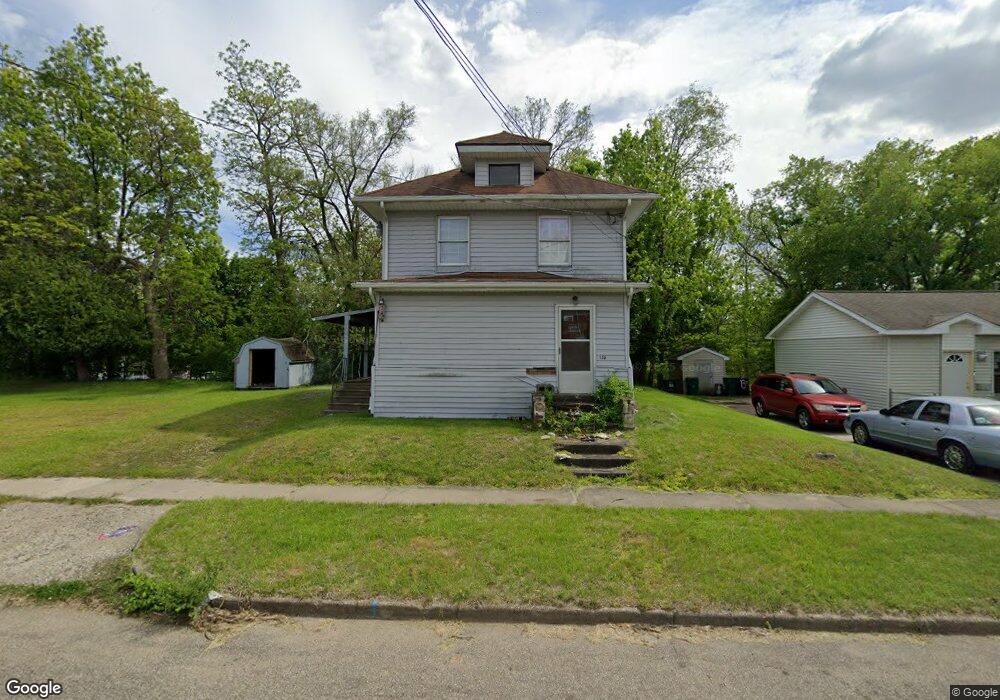
135 Roseneath Ave Battle Creek, MI 49037
North Central NeighborhoodEstimated Value: $87,000 - $114,000
3
Beds
2
Baths
1,232
Sq Ft
$79/Sq Ft
Est. Value
About This Home
This home is located at 135 Roseneath Ave, Battle Creek, MI 49037 and is currently estimated at $97,699, approximately $79 per square foot. 135 Roseneath Ave is a home located in Calhoun County with nearby schools including Dudley School, Northwestern Middle School, and Battle Creek Central High School.
Ownership History
Date
Name
Owned For
Owner Type
Purchase Details
Closed on
Apr 8, 2011
Sold by
Franklin Madeline M and Franklin Dennie G
Bought by
Franklin Dennie G and Franklin Taj A
Current Estimated Value
Purchase Details
Closed on
Feb 19, 2009
Sold by
Franklin Madeline M
Bought by
Franklin Madeline M and Franklin Dennie G
Purchase Details
Closed on
Jan 10, 1997
Sold by
Franklin Dennis G
Bought by
Franklin Madeline M
Purchase Details
Closed on
Dec 17, 1996
Bought by
Franklin
Create a Home Valuation Report for This Property
The Home Valuation Report is an in-depth analysis detailing your home's value as well as a comparison with similar homes in the area
Home Values in the Area
Average Home Value in this Area
Purchase History
| Date | Buyer | Sale Price | Title Company |
|---|---|---|---|
| Franklin Dennie G | -- | None Available | |
| Franklin Madeline M | -- | None Available | |
| Franklin Madeline M | -- | -- | |
| Franklin | $8,200 | -- |
Source: Public Records
Tax History Compared to Growth
Tax History
| Year | Tax Paid | Tax Assessment Tax Assessment Total Assessment is a certain percentage of the fair market value that is determined by local assessors to be the total taxable value of land and additions on the property. | Land | Improvement |
|---|---|---|---|---|
| 2025 | -- | $31,500 | $0 | $0 |
| 2024 | $779 | $26,365 | $0 | $0 |
| 2023 | $991 | $22,780 | $0 | $0 |
| 2022 | $704 | $18,755 | $0 | $0 |
| 2021 | $942 | $17,621 | $0 | $0 |
| 2020 | $1,127 | $15,387 | $0 | $0 |
| 2019 | $1,077 | $14,046 | $0 | $0 |
| 2018 | $1,077 | $14,031 | $349 | $13,682 |
| 2017 | $1,102 | $15,984 | $0 | $0 |
| 2016 | $1,131 | $18,266 | $0 | $0 |
| 2015 | $1,108 | $19,377 | $1,146 | $18,231 |
| 2014 | $1,108 | $17,249 | $1,146 | $16,103 |
Source: Public Records
Map
Nearby Homes
- 188 Roseneath Ave
- 52 Roseneath Ave
- 5 Beglin Ct
- 216 Kendall St N
- 224 Hubbard St
- 435 Kendall St N
- 253 Greenwood Ave
- 125 Oaklawn Ave
- 46 Walter Ave
- 60 Graves Ave
- 69 Jordan St
- 89 Somerset Ave
- 35 Hubbard St
- 562 Van Buren St W
- 0 W Vanburen 032 St Unit 22040288
- 0 W Vanburen 025 St Unit 22040286
- 0 W Vanburen 027 St Unit 22040287
- 129 Fox Ave
- 0 W Michigan 011 Ave Unit 22040285
- 0 W Michigan 010 Ave Unit 22040284
- 139 Roseneath Ave
- 311 Kendall St N
- 136 Roseneath Ave
- 143 Roseneath Ave
- 307 Kendall St N
- 148 Roseneath Ave
- 142 Roseneath Ave
- 316 Kendall St N
- 308 Kendall St N
- 122 Roseneath Ave
- 337 Kendall St N
- 299 Kendall St N
- 115 Roseneath Ave
- 166 Oneita St
- 149 Oneita St
- 143 Oneita St
- 116 Roseneath Ave
- 306 Kendall St N
- 341 Kendall St N
- 297 Kendall St N