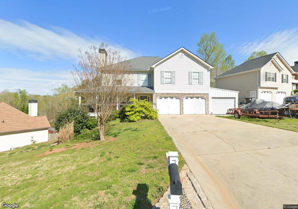
135 Sable Trace Trail Acworth, GA 30102
Oak Grove NeighborhoodEstimated Value: $444,481 - $485,000
4
Beds
3
Baths
2,436
Sq Ft
$191/Sq Ft
Est. Value
About This Home
This home is located at 135 Sable Trace Trail, Acworth, GA 30102 and is currently estimated at $464,741, approximately $190 per square foot. 135 Sable Trace Trail is a home located in Cherokee County with nearby schools including Oak Grove Elementary School, E. T. Booth Middle School, and Etowah High School.
Ownership History
Date
Name
Owned For
Owner Type
Purchase Details
Closed on
Apr 15, 2005
Sold by
Dixie Developing & Building Inc
Bought by
Johnson Austin L and Johnson Kelly
Current Estimated Value
Home Financials for this Owner
Home Financials are based on the most recent Mortgage that was taken out on this home.
Original Mortgage
$203,110
Outstanding Balance
$104,197
Interest Rate
5.79%
Mortgage Type
New Conventional
Estimated Equity
$360,544
Create a Home Valuation Report for This Property
The Home Valuation Report is an in-depth analysis detailing your home's value as well as a comparison with similar homes in the area
Home Values in the Area
Average Home Value in this Area
Purchase History
| Date | Buyer | Sale Price | Title Company |
|---|---|---|---|
| Johnson Austin L | $213,800 | -- |
Source: Public Records
Mortgage History
| Date | Status | Borrower | Loan Amount |
|---|---|---|---|
| Open | Johnson Austin L | $203,110 |
Source: Public Records
Tax History Compared to Growth
Tax History
| Year | Tax Paid | Tax Assessment Tax Assessment Total Assessment is a certain percentage of the fair market value that is determined by local assessors to be the total taxable value of land and additions on the property. | Land | Improvement |
|---|---|---|---|---|
| 2025 | $4,171 | $178,640 | $33,795 | $144,845 |
| 2024 | $4,148 | $178,640 | $33,795 | $144,845 |
| 2023 | $3,713 | $178,640 | $33,796 | $144,844 |
| 2022 | $3,493 | $145,520 | $32,000 | $113,520 |
| 2021 | $3,099 | $116,400 | $24,000 | $92,400 |
| 2020 | $2,926 | $108,800 | $22,000 | $86,800 |
| 2019 | $2,823 | $104,400 | $22,000 | $82,400 |
| 2018 | $2,593 | $93,880 | $19,200 | $74,680 |
| 2017 | $2,584 | $231,600 | $19,200 | $73,440 |
| 2016 | $2,357 | $208,200 | $19,200 | $64,080 |
| 2015 | $2,122 | $186,200 | $15,200 | $59,280 |
| 2014 | $2,080 | $182,300 | $13,000 | $59,920 |
Source: Public Records
Map
Nearby Homes
- 148 Sable Trace Trail
- 400 Sable Trace Cove
- The Fenton Plan at Buice Lake - Madison
- The Davis Plan at Buice Lake - Madison
- 5666 Goldfield Dr
- 5689 Woodland Dr
- 307 Queensbury Walk
- 3094 Cambridge Mill St
- 3070 Cambridge Mill St
- 849 York Alley
- 544 Aberdeen Meadow Ln
- 3086 Cambridge Mill St
- 648 Devon Alley
- 3061 Cambridge Mill St
- 3098 Cambridge Mill St
- 154 Bryon Ln
- 6390 Woodstock Rd
- 137 Sable Trace Trail
- 133 Sable Trace Trail
- 162 Sable Trace Trail
- 139 Sable Trace Trail
- 160 Sable Trace Trail
- 131 Sable Trace Trail
- 158 Sable Trace Trail
- 164 Sable Trace Trail
- 141 Sable Trace Trail
- 156 Sable Trace Trail
- 154 Sable Trace Trail
- 166 Sable Trace Trail
- 802 Sable Trace Hollow
- 129 Sable Trace Trail
- 152 Sable Trace Trail
- 0 Sable Trace Hollow Unit 7602693
- 803 Sable Trace Hollow
- 143 Sable Trace Trail
- 190 Sable Trace Trail
- 145 Sable Trace Trail